Friday 27 Nov 2020- fog, low cloud and temperatures
64 views
Skip to first unread message

Smartie
Nov 27, 2020, 6:05:43 AM11/27/20
to Weather and Climate
I'm sure others will have more to say on this but just to point out the range of processes that a model has to capture to predict low cloud clearance and fog see here-
Unfortunately there's no suitable routine verification location in the NW to see how well the UKV did , but overnight for Heathrow this one of the biggest errors I've seen (was 3.2C at one point). Attached.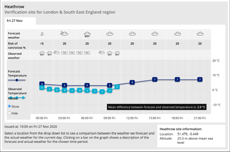

Julian Mayes
Nov 27, 2020, 7:20:29 AM11/27/20
to Weather and Climate
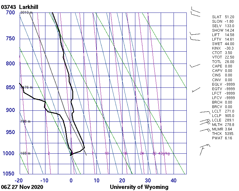
Yes, this is turning into a fascinating week down here. I'm struck by the dryness of the air in the subsidence inversion shown in the t'gram in the other forum and how this can mix down to clear the low cloud.
Whatever the exact processes, the fact that they can change cloud amount quickly and occur in local areas (giving sharp cloud boundaries) means that forecasters must study satellite imagery and current observations and be prepared to alter the forecast as they go. It was obvious it was going to start colder than forecast at Heathrow last night ( as my clumsily uploaded sunset photo shows https://groups.google.com/g/weatherandclimate/c/0ZV_E9zjgSs ). I wonder if model output was assuming low cloud or fog forming or the advection back of the frontal cloud? Certainly, fog formed in the more rural areas around here before midnight.
Verification of any model against Heathrow at night must also take account of the fact that it is a relatively warm site overnight. Cold air comes right up to built-up areas - last night's min for example at Teddington (Bushy Park), 1 mile from where I took the photo was -1.9C. At the normally colder Wisley to the south, it stayed above 0C. This may have been due to the approach yet again of the frontal cloud band from the south. At my location (between these two sites), a thin layer of Scu was visible overnight in the southern sky, tending to edge north until the whole view was obscured by fog in the second half of the night.
Julian

Freddie
Nov 27, 2020, 10:18:03 AM11/27/20
to Weather and Climate
On Friday, 27 November 2020 at 12:44:29 UTC Smartie wrote:
BTW thanks to whoever tagged the post - I don't seem to have permissions to do that.
Sadly, under the new groups UI it is only myself as group owner who can tag/label posts. I keep up-to-date with this when I can.
I will do a post about labels over the weekend, as I am open to tailoring the list of labels (as currently defined) to better fit the needs of the group.
--
Freddie
Alcaston
Shropshire
148m AMSL
Stats for the month so far: https://www.hosiene.co.uk/weather/statistics/latest.xlsx
Smartie
Nov 28, 2020, 5:44:49 AM11/28/20
to Weather and Climate
Thanks Freddie,
David
Reply all
Reply to author
Forward
0 new messages