which EPSG codes are missing

Martin Isenburg

Kirk Waters - NOAA Federal
--
Download LAStools at
http://lastools.org
http://rapidlasso.com
Be social with LAStools at
http://facebook.com/LAStools
http://twitter.com/LAStools
http://linkedin.com/groups/LAStools-4408378
Manage your settings at
http://groups.google.com/group/lastools/subscribe

Baltrusch, Sven
Hello Martin,
attached you can find a list of EPSG-codes, which are used in german mapping agencies.
Best regards, Sven
Landesamt für innere Verwaltung Mecklenburg-Vorpommern
Amt für Geoinformation, Vermessungs- und Katasterwesen
Fachbereich 322
Lübecker Str. 289
19059 Schwerin
Tel.: 0385 588-56322
Fax: 0385 588 482 56039
E-Mail: sven.ba...@laiv-mv.de
--

Žiga Kokalj
Dear Martin,
for Slovenia we use:
3912 ; SI-D48, Slovene National Grid, »old« but still mostly used
3794 ; SI-D96, Slovenia 1996 / Slovene National Grid, new and should be used (ETRS89)
It would be great to have them in LAStools.
Best wishes,
Ziga
Martin Isenburg
I added the newer projection. Not so sure about the older one. I see a
whole bunch of different codes referring to it. See:
http://www.spatialreference.org/ref/sr-org/6769/
I like to focus on the most relevant and newer ones to keep LAStools
light and tight. To convert legacy projections to current workflows
there are other tools such as las2las from libLAS as well as
commercial "projection transform engine" ...
Martin

Toon Petermans
Hello Martin,
That is very good news to incorporate more epsg codes.
For Belgian users, we could use the EPSG 31370 for the Belgian Lambert 72 CRS.
http://www.spatialreference.org/ref/epsg/31370/
An important issue is the +towgs84 parameters which is necessary for datum conversions between Belgian datum 72 and ETR89 (WGS84) and vice versa. To make things more complicated the signs of the +towgs84 parameters has to change whether you do a datum transformation from WGS84 to Belgian datum 1972 or from Belgian datum 1972 to ETRS89 datum.
Another complexity is the sign of the rotation parameters which can change depending on the use of the coordinate frame transformation convention (positive counterclockwise – mainly used in the US) and the Position vector transformation convention (mainly used in Europe and also In the epsg codes). It is crucial that sign convention is conform the algorithm in the application.
From ETRS89 datum to Belgian datum72 in Position vector transformation : towgs84= 106.869,-52.2978,103.724,-0.33657,0.456955,-1.84218,1
ð These are the parameters that the epsg database uses
From ETRS89 datum to Belgian datum 72 in Coordinate frame transformation : towgs84= 106.869,-52.2978,103.724,0.33657,-0.456955,1.84218,1
From Belgian datum 72 to ETRS89 datum in Position vector transformation : towgs84= -106.869,52.2978,-103.724,0.33657,-0.456955,1.84218,1
From Belgian datum 72 to ETRS89 datum in Coordinate frame transformation : towgs84= -106.869,52.2978,-103.724,-0.33657,0.456955,-1.84218,1
A third complication is that the National Geographic Institute of Belgium uses parameters (with coordinate frame transformation convention) with more detail than the ones in the espg code:

So in the end it would be very helpful to choose an epsg code but to have the ability to manually modify the towgs84 parameters (the signs for whatever transformation convention you want). But in the first place, will lastools be able to use the towgs parameters for datum shifts in the future or to manually introduce it?
Best regards,
Toon
Toon Petermans
Afdeling Geodiensten – Dienst IT/Development
T 09 261 7217 | F 09 261 52 99 | toon.pe...@agiv.be | www.agiv.be
Vrijdag 4/5de verlofdag
![]()
--
Download LAStools at
http://lastools.org
http://rapidlasso.com
Be social with LAStools at
http://facebook.com/LAStools
http://twitter.com/LAStools
http://linkedin.com/groups/LAStools-4408378
Manage your settings at
http://groups.google.com/group/lastools/subscribe

Thomas Knudsen
4093 ETRS89/DKTM1
4094 ETRS89/DKTM2
4095 ETRS89/DKTM3
4096 ETRS89/DKTM4
4097 ETRS89/DKTM1+DVR90
4098 ETRS89/DKTM2+DVR90
4099 ETRS89/DKTM3+DVR90
4100 ETRS89/DKTM4+DVR90
![Kramer, Henk [Alterra]'s profile photo](http://lh3.googleusercontent.com/a-/ALV-UjU7MCdHNkTp0O0Qr5r5KaUpNs0d5NIIV4MUQb5IkLYlYSB2ltE=s40-c)
Kramer, Henk [Alterra]
Hi Martin,
Could you add EPSG:28992 (amersfoort / RDnew) for the Netherlands?
http://spatialreference.org/ref/epsg/28992/
Thanks,
Henk
Henk Kramer
Centrum Geo-informatie
Alterra
Wageningen
tel. 0317-481816
--

Jonathan Dash
Hi Martin
EPSG:2193 - (NZGD2000 / New Zealand Transverse Mercator 2000) covers the North and South islands of New Zealand and would be a useful addition.
http://spatialreference.org/ref/epsg/2193/
Thanks
Jonathan
Jonathan Dash
Scientist, Forest Operations and Management, Scion
--
Download LAStools at
http://lastools.org
http://rapidlasso.com
Be social with LAStools at
http://facebook.com/LAStools
http://twitter.com/LAStools
http://linkedin.com/groups/LAStools-4408378
Manage your settings at
http://groups.google.com/group/lastools/subscribe
This e-mail and any attachments may contain information which is confidential or subject to copyright. If you receive this e-mail in error, please delete it.
Scion does not accept responsibility for anything in this e-mail which is not provided in the course of Scion’s usual business or for any computer virus, data corruption, interference or delay arising from this e-mail.

sh...@shaunlevick.com

John Scrivani
EPSG:2924 NAD_1983_HARN_StatePlane_Virginia_North_FIPS_4502_Feet
EPSG:2925 NAD_1983_HARN_StatePlane_Virginia_South_FIPS_4502_Feet
Most, if not all, Virginia state and local governments, use these two.
In addition, this one is commonly used for statewide projects, although no lidar data has been delivered in it:
EPSG:3969 NAD_1983_HARN_Virginia_Lambert
It would be great to have the first two, and if possible, the third, supported in lastools.
John Scrivani,
Geospatial Projects Manager
Virginia Geographic Information Network

Andreas Røstad
Support for the "Norwegian Transverse Mercator" zones and the Norwegian vertical references would be great.
The horisontal EPSG codes are:
5105 ETRS89 / NTM zone 5
5106 ETRS89 / NTM zone 6
5107 ETRS89 / NTM zone 7
5108 ETRS89 / NTM zone 8
5109 ETRS89 / NTM zone 9
5113 ETRS89 / NTM zone 13
5114 ETRS89 / NTM zone 14
5120 ETRS89 / NTM zone 20
5121 ETRS89 / NTM zone 21
NTM is used in Norway for construction engineering, including road and railroad work, where LiDAR scanning is in widespread use (for planning as well as maintenance purposes).
The vertical crs EPSG codes are:
We are converting to NN2000, but both will be used for some years more.
Martin Isenburg
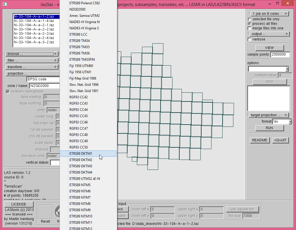
I have added support for certain EPSG codes in th latest version of
LAStools from today (131210). You can access (and add) them either via
the GUI or directly via the command line using the '-epsg' and
'-target_epsg' flags. Note that it is still not possible to do a
ellispoid transform ...
Let me know if there are additional codes dear to your heart (that are
used in LiDAR). I appreciate a small example LAZ file using the
projection for testing purposes.
Regards,
Martin
D:\lastools\bin>las2las -epsg help
set_epsg_code: look-up for 0 not implemented
ERROR: bad ESPG code in '-epsg help'.
2180 - ETRS89 Poland CS92
2193 - NZGD2000
2195 - Amer. Samoa UTM2
2924 - NAD83-H Virginia N
2925 - NAD83-H Virginia S
3034 - ETRS89 LCC
3046 - ETRS89 TM34
3047 - ETRS89 TM35
3048 - ETRS89 TM36
3067 - ETRS89 TM35FIN
3141 - Fiji 1956 UTM60
3142 - Fiji 1956 UTM1
3460 - Fiji Map Grid 1986
3794 - Slov. Nat. Grid 1996
3912 - Slov. Nat. Grid 1901
3942 - RGF93 CC42
3943 - RGF93 CC43
3944 - RGF93 CC44
3945 - RGF93 CC45
3946 - RGF93 CC46
3947 - RGF93 CC47
3948 - RGF93 CC48
3949 - RGF93 CC49
3950 - RGF93 CC50
4093 - ETRS89 DKTM1
4094 - ETRS89 DKTM2
4095 - ETRS89 DKTM3
4096 - ETRS89 DKTM4
4647 - ETRS89 UTM32 zE-N
5105 - ETRS89 NTM5
5106 - ETRS89 NTM6
5107 - ETRS89 NTM7
5108 - ETRS89 NTM8
5109 - ETRS89 NTM9
5110 - ETRS89 NTM10
5111 - ETRS89 NTM11
5112 - ETRS89 NTM12
5113 - ETRS89 NTM13
5114 - ETRS89 NTM14
5115 - ETRS89 NTM15
5116 - ETRS89 NTM16
5117 - ETRS89 NTM17
5118 - ETRS89 NTM18
5119 - ETRS89 NTM19
5120 - ETRS89 NTM20
5121 - ETRS89 NTM21
5122 - ETRS89 NTM22
5123 - ETRS89 NTM23
5124 - ETRS89 NTM24
5125 - ETRS89 NTM25
5126 - ETRS89 NTM26
5127 - ETRS89 NTM27
5128 - ETRS89 NTM28
5129 - ETRS89 NTM29
5130 - ETRS89 NTM30
5650 - ETRS89 UTM33 zE-N
27700 - OSGB 1936
31370 - Belgian Lambert 1972

Henrik Persson
On Tuesday, November 19, 2013 12:29:27 AM UTC+1, Martin Isenburg wrote:

david.herries
VERT_DATUM["Moturiki",2005,
AUTHORITY["EPSG","5162"]],
UNIT["m",1.0],
AXIS["Gravity-related height",UP],
AUTHORITY["EPSG","5764"]]

carolin...@gmail.com
Could you also add the 2972 RGFG95 / UTM zone 22N, which is used in French Guiana?
Thanks for your great job with LAStools.
Caroline
Caroline Bedeau
Chargée d'études Géomatique & Télédétection
Département R&D Pôle de Cayenne
Office National des Forêts
Réserve de Montabo, 97300 Cayenne
0594 25 53 92
carolin...@onf.fr
Kirk Waters - NOAA Federal
843-740-1227 | Charleston, SC 29405
Martin Isenburg
currently the "free" and open source code in LAStools (see the source
files geoprojectionconverter.cpp and geoprojectionconverter.hpp) only
supports geographic coordinates (aka longlat ot latlong) and any
lambert conformal conic (lcc) or transverse mercator (tm) projection,
hence all UTM projections and most stateplanes. If you can point me to
(easy-to-read) open C/C++ source code that implements the transforms
between geographic coordinates and Oblique Stereographic or the
various Albers flavours then I will add them as time permits.
The proj4 library is already incorporated in Howard's libLAS version
of las2las but linking to external libraries would destroy the
"ultra-easy to compile and port" nature of the LGPL LASlib library and
the basic open source tools built upon them. As these more exotic
projections seem to make only a tiny portion of the LiDAR processed by
LAStools it would seem a lot of complexity added for everyone to the
benefit of only few use cases.
All requested lambert conformal conic (lcc) or transverse mercator
(tm) projections were either already supported (2193, 28348, 28349,
28350, 28351, 28352, 28353, 28354, 28355, 28356) or have been added
(e.g. 2972,,2991, 2992,3006) to be part of the next release.
All the above pertains to horizontal datums. It seems the support for
vertical datums is rather spotty across LiDAR software, so I do not
really see the need to add EPSG codes like
VERT_CS["Moturiki",
VERT_DATUM["Moturiki",2005,
AUTHORITY["EPSG","5162"]],
UNIT["m",1.0],
AXIS["Gravity-related height",UP],
AUTHORITY["EPSG","5764"]]
Martin @rapidlasso

Heidemann, Hans
Not much worth the effort to implement the functionality when it is so infrequent that you ever see files with the required metadata.
 H. Karl Heidemann, GISP
- Arthur James Balfour
![Angenent, Arnout [FGBV]'s profile photo](http://lh3.googleusercontent.com/a-/ALV-UjWlB3kkA2sXp5E_Fdgd1-u8IPoAJBtbEmPX3KwHnZSFjarTmQ=s40-c)
Angenent, Arnout [FGBV]
Is there a way to manually enter the vlr contents? I am not looking to execute a transformation with las2las, but just enter the text in the las files; my client requires the vlr information in the las file:
variable length header record 1 of 2:
reserved 43707
user ID 'LASF_Projection'
record ID 34735
length after header 48
description 'GeoKeyDirectoryTag (mandatory)'
GeoKeyDirectoryTag version 1.1.0 number of keys 5
key 1024 tiff_tag_location 0 count 1 value_offset 1 - GTModelTypeGeoKey: ModelTypeProjected
key 2050 tiff_tag_location 34737 count 1 value_offset 6019 - GeogGeodeticDatumGeoKey: DatumE_GRS1980
key 2052 tiff_tag_location 0 count 1 value_offset 9001 - GeogLinearUnitsGeoKey: Linear_Meter
key 3073 tiff_tag_location 0 count 16 value_offset 0 - PCSCitationGeoKey: Projection 1992
key 4097 tiff_tag_location 0 count 14 value_offset 16 - VerticalCitationGeoKey: Kronsztadt 86
variable length header record 2 of 2:
reserved 43707
user ID 'LASF_Projection'
record ID 34737
length after header 29
description 'GeoASCIIParamsTag (optional)'
GeoAsciiParamsTag (number of characters 29)
Projection 1992 Kronsztadt 86
Kind regards,
Fugro Geospatial B.V.
Arnout Angenent
Processing Supervisor
Telephone: +31 (0)70 31 70780 / Mobile: +31 (0)6 29 53 75 04 / Fax: +31 (0)70 31 70750
E-mail: a.ang...@fugro.com / Website: www.fugrogeospatial.com
Address: Dillenburgsingel 69, 2263 HW Leidschendam /
P.O. Box 3000, 2260 DA Leidschendam, The Netherlands
Trade Register Nr: 27152156 / VAT Nr: NL005621409B29
From: last...@googlegroups.com [mailto:last...@googlegroups.com] On Behalf Of Martin Isenburg

Susana Gonzalez
The New Zealand Vertical Datum 2009 (NZVD2009) is the official vertical datum for New Zealand but there are 13 local mean sea level vertical datums. We would like to define Maturiki 1953 to eliminate the need for vertical reference alignment when conflating disparate datasets from another level vertical datum (LVD).
According to the Standard LiDAR Specifications in New Zealand, the Adjustment to local vertical datum is required in these circumstances:
. Where the vertical accuracy is exceeded when the Geoid derived orthometric heights are validated against LVD.
. Where a bias in the vertical validation resulting from anomalies in the Geoid model or other sources is identified across the whole project area.
Cheers
Susana Gonzalez
Forest Engineer, LiDAR Science
Interpine Group Ltd
NZ Office : 07 350 3209 extn 722
Australia: 02 8011 3645
Fax : 07 345 7571
Address : 99 Sala Street, PO Box 1209, Rotorua 3010, New Zealand
Website : www.interpine.co.nz

Dennis Shimer
EPSG:3728: NAD83(NSRS2007) / Ohio North (ftUS)
EPSG:3729: NAD83(NSRS2007) / Ohio South (ftUS)
EPSG:3734: NAD83 / Ohio North (ftUS)
EPSG:3735: NAD83 / Ohio South (ftUS)
EPSG:3753: NAD83(HARN) / Ohio North (ftUS)
EPSG:3754: NAD83(HARN) / Ohio South (ftUS)
http://spatialreference.org/ref/?search=ohio+ftus&srtext=Search
a...@uni-muenster.de
it would be great if you could add the EPSG 3763 (ETRS89 / Portugal TM06) code which is used for Portugal.
Thanks,
André

Matt Weber
Thank you for taking requests. For research we are in the process of converting our old LiDAR data into EPSG 6418 - NAD83 (2011) California State Plane II (US Feet). It would be tremendously helpful to have that supported in las2las!

carlisle haworth
On Monday, November 18, 2013 at 3:29:27 PM UTC-8, Martin Isenburg wrote:
Martin Isenburg

luke dow

Evon Silvia

Kim Mantey
Martin Isenburg

BarendErasmus
Could you please consider adding EPSG 2054? http://epsg.io/2054 It is a country-specific projection for South Africa.
'best
Barend Erasmus

Wimala van Iersel
Hi Martin,
Could you please add EPSG:28992 (Amersfoort / RD New) for the Netherlands? The Dutch national LiDAR data set is in this coordinate system.
http://spatialreference.org/ref/epsg/28992/
Thank you,
Wimala
Op dinsdag 19 november 2013 00:29:27 UTC+1 schreef Martin Isenburg:
Martin Isenburg
Wimala van Iersel

Howard Butler
https://github.com/OSGeo/proj.4/blob/master/src/PJ_stere.c
https://github.com/OSGeo/proj.4/blob/master/src/PJ_sterea.c
Howard
Dennis Shimer

Michal Gallay
with regard to the missing EPSG codes, I would like to ask if the EPSG
5514 (Krovak EastNorth projections) could be added to the list of
projections.
It is the projection of lidar data distributed as DMR4G (Digital Model
of Relief 4th generation) for the Czech Republic.
http://www.gisat.cz/images/upload/c3256_petr-dusanek-prezentace-pro-gisat-130925.pdf
(presentation in Czech language)
Czech National Surveying and Cadastral Office
http://geoportal.cuzk.cz/%28S%28cfdqoze12z4wcv1kbk32igal%29%29/Default.aspx?mode=TextMeta&metadataXSL=full&side=vyskopis&metadataID=CZ-CUZK-DMR4G-V
The EPSG 5514 code is also relevant for the territory of Slovak
Republic, for which no national coverage exists but we have some
custom data from tailored missions also other research institutions in
Slovakia.
Thanks for consideration
Michal Gallay
Pavol Jozef Šafárik University in Košice, Slovakia
> Download LAStools at
> http://lastools.org
> http://rapidlasso.com
> Be social with LAStools at
> http://facebook.com/LAStools
> http://twitter.com/LAStools
> http://linkedin.com/groups/LAStools-4408378
> Manage your settings at
> http://groups.google.com/group/lastools/subscribe
--
zástupca riaditeľa pre vedecko-výskumnú činnosť a zahraničné vzťahy
výskumný pracovník
Ústav geografie, Prírodovedecká fakulta
Univerzita Pavla Jozefa Šafárika v Košiciach
Jesenná 5
040 01 Košice
Deputy director for research and foreign relations
Research assistant
Institute of Geography
Faculty of Natural Sciences
Pavol Jozef Šafárik University in Košice
Jesenná 5
040 01 Košice, Slovakia
Tel: 00421 (0) 55 234 2352
Web: http://geo.ics.upjs.sk/
Web:http://www.upjs.sk/prirodovedecka-fakulta/
Martin Isenburg

Petr.D...@cuzk.cz
Hallo Martin and Michal,
Martin I understood you do not want to add Krovak, it is really rear and strange projection. Even you apply the results will not be good enough for such precise data like LiDAR is.
For you Michal. Even if you use classical transformation like you find in proj 4 library, You will get bad results (In CZ mistake can by up to 3-5 meters, I do not know it in Slovakia). The problem is that JTSK network is inhomogenous so you need to apply so cold “Grid shift transformation”. It means you apply classical transformation and then you have some grid of X, Y corrections. Precision of corrections depends on density of that grid nad quality of geodetical observations. This grid should be provided by your national Land Survey Office (Úrad geodézie, kartografie a katastra Slovenskej republiky).
Best Results,
Petr
From: last...@googlegroups.com [mailto:last...@googlegroups.com] On Behalf Of Martin Isenburg
Sent: Thursday, December 03, 2015 9:48 PM
To: LAStools - efficient command line tools for LIDAR processing
Martin Isenburg
--

Luiz Carlos Estraviz Rodriguez
Luiz Carlos Estraviz Rodriguez
Martin Isenburg
lanc...@unavco.org
On Monday, November 18, 2013 at 4:29:27 PM UTC-7, Martin Isenburg wrote:

Mark Levitski
Martin Isenburg
Mark Levitski
Martin Isenburg
Mark Levitski
Yay! I should have thought there was a library somewhere for that.You have created such a wonderful life for yourself! Thanks, Martin.Mark
Martin Isenburg
PS: It seems rather odd that your LiDAR file has only *single* returns. I doubt that this should be like that. Export / processing error?
Mark Levitski
Martin Isenburg
lanc...@unavco.org
Martin Isenburg
The support of "vertical epsg" codes (aka 5103, 5168, 5770 and 6360) is not that great in LAStools. It's not done via the '-epsg' switch which refers always to "horizontal epsg" codes. The vertical ones are implemented via '-vertical_xxxxxxx' switches (see [1] for the current list) and are exclusively of "informative" nature and not used in computations. Some more reasoning for their need would be required for me to lift them from the bottom of a long todo list.
[1] https://github.com/LAStools/LAStools/blob/master/src/geoprojectionconverter.cpp#L6803
e:\LAStools\bin>las2las -i ..\data\fusa.laz -epsg 3500 -o fusa_3500.laz
e:\LAStools\bin>lasinfo -i fusa_3500.laz-nh -nc
lasinfo (180422) report for 'fusa_3500.laz'
variable length header record 1 of 1:
reserved 0
user ID 'LASF_Projection'
record ID 34735
length after header 40
description 'by LAStools of rapidlasso GmbH'
GeoKeyDirectoryTag version 1.1.0 number of keys 4
key 1024 tiff_tag_location 0 count 1 value_offset 1 - GTModelTypeGeoKey: ModelTypeProjected
key 3076 tiff_tag_location 0 count 1 value_offset 9003 - ProjLinearUnitsGeoKey: Linear_Foot_US_Survey
key 4099 tiff_tag_location 0 count 1 value_offset 9001 - VerticalUnitsGeoKey: Linear_Meter
e:\LAStools\bin>las2las -i ..\data\fusa.laz -epsg 3500 -vertical_navd88 -elevation_survey_feet -o fusa_3500navd88USft.laz
e:\LAStools\bin>lasinfo -i fusa_3500navd88USft.laz -nh -nc
lasinfo (180422) report for 'fusa_3500navd88USft.laz'
variable length header record 1 of 1:
reserved 0
user ID 'LASF_Projection'
record ID 34735
description 'by LAStools of rapidlasso GmbH'
key 1024 tiff_tag_location 0 count 1 value_offset 1 - GTModelTypeGeoKey: ModelTypeProjected
key 3076 tiff_tag_location 0 count 1 value_offset 9003 - ProjLinearUnitsGeoKey: Linear_Foot_US_Survey
key 4096 tiff_tag_location 0 count 1 value_offset 5103 - VerticalCSTypeGeoKey: VertCS_North_American_Vertical_Datum_1988
Kirk Waters - NOAA Federal
Sent from a mobile device subject to autocorrect errors.
lanc...@unavco.org
Evon Silvia

Russell Main
Martin Isenburg
stancom...@gmail.com
Alex
Martin Isenburg
--
tol...@student.nhl.nl
Op donderdag 14 juni 2018 17:05:18 UTC+2 schreef Martin Isenburg: