Wrong maps!
12 views
Skip to first unread message

Jabran
Sep 16, 2009, 5:23:34 PM9/16/09
to map-countr...@googlegroups.com
Hi Team,
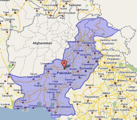
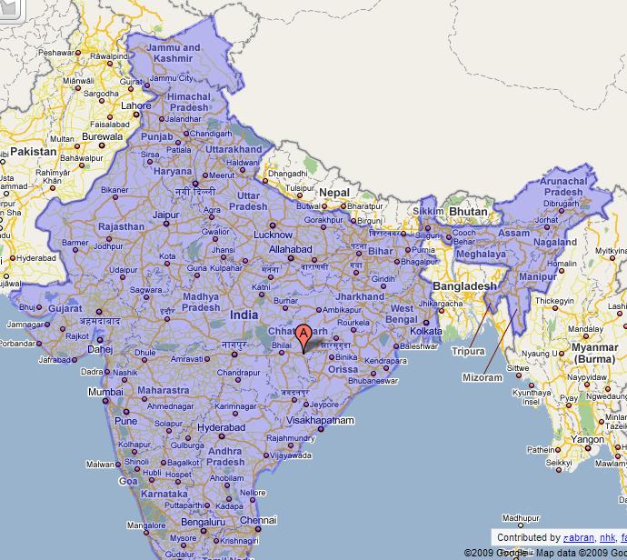
I do not intend to create a political debate or discussion. But a simple answer could do the job. Attached are images representing the maps for Pakistan and India. Since Kashmir is a disputed area as till date by UN and rest of both countries then why it is represented like this instead of taking it into a disputed territory as like official maps do. Here is the link for official map for Pakistan which shows the Kashmir as disputed territory. I hope same as the official Indian map should do. So is it taking an advantage of being in the country as a controller of the software or some else logic involved in it?
P.S. Only reply from team members plz.
Cheers

momers
Sep 17, 2009, 1:26:58 AM9/17/09
to Map Your World - Country-specific topics
Google Earth does a good job of showing disputed borders in different
colours: Red and Orange.
I believe that in a way the polygons on GMM are correct in that these
regions are being Administered by both the respective countries. But
the polygon should not be considered to verify or authenticate any
countries claims, till politically resolved.
What mapmaker can do is use a scheme like GE to highlight the disputed
borders for clarity on maps.
On Sep 17, 3:23 am, Jabran <jabranrafi...@gmail.com> wrote:
> Hi Team,
>
> I do not intend to create a political debate or discussion. But a simple
> answer could do the job. Attached are images representing the maps for
> Pakistan and India. Since Kashmir is a disputed area as till date by UN and
> rest of both countries then why it is represented like this instead of
> taking it into a disputed territory as like official maps do. Here is the
> link for official map for Pakistan which shows the Kashmir as disputed
> territory. I hope same as the official Indian map should do. So is it taking
> an advantage of being in the country as a controller of the software or some
> else logic involved in it?
>
> http://www.pakistan.gov.pk/ministries/ContentInfo.jsp?MinID=6&cPath=5...
> Regards,
> جabranwww.dyzynz.net
>
> 123123.JPG
> 74KViewDownload
>
> 3123123213.JPG
> 131KViewDownload
colours: Red and Orange.
I believe that in a way the polygons on GMM are correct in that these
regions are being Administered by both the respective countries. But
the polygon should not be considered to verify or authenticate any
countries claims, till politically resolved.
What mapmaker can do is use a scheme like GE to highlight the disputed
borders for clarity on maps.
On Sep 17, 3:23 am, Jabran <jabranrafi...@gmail.com> wrote:
> Hi Team,
>
> I do not intend to create a political debate or discussion. But a simple
> answer could do the job. Attached are images representing the maps for
> Pakistan and India. Since Kashmir is a disputed area as till date by UN and
> rest of both countries then why it is represented like this instead of
> taking it into a disputed territory as like official maps do. Here is the
> link for official map for Pakistan which shows the Kashmir as disputed
> territory. I hope same as the official Indian map should do. So is it taking
> an advantage of being in the country as a controller of the software or some
> else logic involved in it?
>
> P.S. Only reply from team members plz.
>
> Cheers
> <http://www.pakistan.gov.pk/ministries/ContentInfo.jsp?MinID=6&cPath=5...>
>
> Cheers
> Regards,
> جabranwww.dyzynz.net
>
> 123123.JPG
> 74KViewDownload
>
> 3123123213.JPG
> 131KViewDownload
Jabran
Nov 13, 2009, 1:19:14 PM11/13/09
to map-countr...@googlegroups.com
I think maybe it will take years to come any answer for a post like that. :) I will keep posting things happening associated with this; meanwhile. Here is news which actually describes the ability of Google to favour territories in a special way. http://www.sfgate.com/cgi-bin/article.cgi?f=/g/a/2009/10/22/urnidgns852573C40069388000257658001CE2F9.DTL
What policy is this anyway..
2009/9/16 Jabran <jabran...@gmail.com>

JenMazz
Nov 23, 2009, 2:24:32 PM11/23/09
to Map Your World - Country-specific topics
Dear momers & Jabran,
Thanks for you suggestions on how we might more clearly display a
place's disputed status. These are sensitive issues to be sure. Please
also see my response on a separate post, which I think applies here as
well:
http://groups.google.com/group/mapping-howto/browse_thread/thread/1db858479bd30e28
Cheers,
Jen.
On Nov 13, 10:19 am, Jabran <jabranrafi...@gmail.com> wrote:
> I think maybe it will take years to come any answer for a post like that. :)
> I will keep posting things happening associated with this; meanwhile. Here
> is news which actually describes the ability of Google to favour territories
> in a special way.http://www.sfgate.com/cgi-bin/article.cgi?f=/g/a/2009/10/22/urnidgns8...
> 2009/9/16 Jabran <jabranrafi...@gmail.com>
> > Regards,
> > جabran
> >www.dyzynz.net
Thanks for you suggestions on how we might more clearly display a
place's disputed status. These are sensitive issues to be sure. Please
also see my response on a separate post, which I think applies here as
well:
http://groups.google.com/group/mapping-howto/browse_thread/thread/1db858479bd30e28
Cheers,
Jen.
On Nov 13, 10:19 am, Jabran <jabranrafi...@gmail.com> wrote:
> I think maybe it will take years to come any answer for a post like that. :)
> I will keep posting things happening associated with this; meanwhile. Here
> is news which actually describes the ability of Google to favour territories
> 2009/9/16 Jabran <jabranrafi...@gmail.com>
>
>
>
> > Hi Team,
>
> > I do not intend to create a political debate or discussion. But a simple
> > answer could do the job. Attached are images representing the maps for
> > Pakistan and India. Since Kashmir is a disputed area as till date by UN and
> > rest of both countries then why it is represented like this instead of
> > taking it into a disputed territory as like official maps do. Here is the
> > link for official map for Pakistan which shows the Kashmir as disputed
> > territory. I hope same as the official Indian map should do. So is it taking
> > an advantage of being in the country as a controller of the software or some
> > else logic involved in it?
>
> >http://www.pakistan.gov.pk/ministries/ContentInfo.jsp?MinID=6&cPath=5...
>
>
> > Hi Team,
>
> > I do not intend to create a political debate or discussion. But a simple
> > answer could do the job. Attached are images representing the maps for
> > Pakistan and India. Since Kashmir is a disputed area as till date by UN and
> > rest of both countries then why it is represented like this instead of
> > taking it into a disputed territory as like official maps do. Here is the
> > link for official map for Pakistan which shows the Kashmir as disputed
> > territory. I hope same as the official Indian map should do. So is it taking
> > an advantage of being in the country as a controller of the software or some
> > else logic involved in it?
>
>
> > P.S. Only reply from team members plz.
>
> > Cheers
> > <http://www.pakistan.gov.pk/ministries/ContentInfo.jsp?MinID=6&cPath=5...>
> > P.S. Only reply from team members plz.
>
> > Cheers
> > Regards,
> > جabran
> >www.dyzynz.net
Reply all
Reply to author
Forward
0 new messages