Display Turf zones in OsmAnd
86 views
Skip to first unread message

Leif Larsson
Jun 19, 2013, 3:17:24 AM6/19/13
to osm...@googlegroups.com
Now I need help from you experts out there.
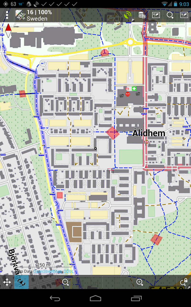
In the attached image you can see turf zones displayed as red areas (see http://turfgame.com/) in Locus Maps. The positions of these zones I fetched from http://turf.urbangeeks.org/
I would like to have the zones displayed in OsmAnd but so far I have miserably failed in my attempts. Could someone please help?

Hardy
Jun 19, 2013, 3:35:27 AM6/19/13
to osm...@googlegroups.com
Leif, are they points or areal features?
If they are points, it is quite easy:
Produce a GPX file containing them as waypoints, then simply display via our "Define View/GPX" function, or create a Favorites file and display them via Favorites. Look at existing files of both types to see how they need to be formatted. You can produce your file from the location data you have using any spreadsheet application and a bit of string manipulation.
If you want to display areal features, you will have to go more complex ways, like creating a sqlite tile map in something like MobileAtlasCreator and using it as overlay in Osmand (via the Online maps,/ Overlay feature), or creating your own obf vector map using OsmandMapCreator.
Best, Hardy
Leif Larsson
Jun 19, 2013, 3:39:34 AM6/19/13
to osm...@googlegroups.com
I should think they are areas. I have attached a file to illustrate this. Hmm, seems a bit too complicated for me doing it the complex way. :(
--
You received this message because you are subscribed to a topic in the Google Groups "Osmand" group.
To unsubscribe from this topic, visit https://groups.google.com/d/topic/osmand/-hFofiStADY/unsubscribe.
To unsubscribe from this group and all its topics, send an email to osmand+un...@googlegroups.com.
For more options, visit https://groups.google.com/groups/opt_out.
Leif Larsson
Jun 19, 2013, 3:44:29 AM6/19/13
to osm...@googlegroups.com
This is what it says on Urbangeeks page:
"If you want to use another map application like OsmAnd that doesn't support this you might have to select the file output format "KML - POIs only"."
But what is the next step in OsmAnd if I make a "KML - POIs only" file? I feel like a total n00b. :(
"If you want to use another map application like OsmAnd that doesn't support this you might have to select the file output format "KML - POIs only"."
But what is the next step in OsmAnd if I make a "KML - POIs only" file? I feel like a total n00b. :(
Hardy
Jun 19, 2013, 5:16:42 AM6/19/13
to osm...@googlegroups.com
Well, see attached. I used the free software GPSBabel, and simply converted the kml file you provided to GPX XML, using their default parameters.
If you put this file in osmand/tacks on your sd card, you can display it in OsmAnd using Menu/Define View/GPX track.
You will see the points marked, but no description. Not sure if I lost any description in the conversion, or if there was nothing in the first place. (if you want descriptions, they need to be inside <name> tags, check your favorites.gpx file to see how to do it.
Best,
Hardy
Reply all
Reply to author
Forward
0 new messages