PIN code geocoding

S Anand

Arun Ganesh
j.mp/ArunGanesh
Arun Ganesh
j.mp/ArunGanesh

Deepak Shenoy
On Mar 6, 11:34 pm, S Anand <root.n...@gmail.com> wrote:
> As discussed in yesterday's datameet, I've set up a crowd-sourced effort to
> map PIN codes:http://pincode.datameet.org/
>
> It's seeded with 11,000 PIN codes from GeoNames:http://download.geonames.org/export/zip/
site I mean.
http://pincode.net.in/ has 152,000 pin codes, and we could use
wikiscraper or a custom program to get them.
We could run through the pin-code search at http://www.indiapost.gov.in/Pin/Pinsearch.aspx
and get a list of pin codes (gotta do a scraper).
Then use Google Geocoder which has a simple API, just pass
sensor=false&address=[city], India [pincode]. You'll most likely get a
few results, wtih lat/lng, put that into the database, let the crowd
come in and choose the PO directly or choose of of them options.
> 3. Any thoughts on how we can merge this with the efforts of hundreds of
> others doing the same thing are welcome. Hate to overlap effort.
One way to handle overlaps is a) announce it and b) create an api for
people to use (say GetGeoAddress given PinCode). If you know of any of
the overlaps, why don't we list 'em and let's contact everyone and get
the pieces flowing.
Btw, I couldn't be on the skype meet. I'm trying to do stuff to
visualize the budget, am based in Gurgaon, write on financial stuff
and economics in India at www.capitalmind.in, was a programmer in a
past life and am getting back to it, and I constantly work at
visualizing financial data on the blog and privately for investing
ideas. (One of the pieces I'd done was
http://blog.investraction.com/2010/02/bharti-zain-deal-analysis.html -
but that's more or less static.)
S Anand
Awesome. How did you do this? It's pretty darn cool = the pincode sub-site I mean.
http://pincode.net.in/ has 152,000 pin codes, and we could use
wikiscraper or a custom program to get them.
Then use Google Geocoder which has a simple API, just pass
sensor=false&address=[city], India [pincode]. You'll most likely get a
few results, wtih lat/lng, put that into the database, let the crowd
come in and choose the PO directly or choose of of them options.
One way to handle overlaps is a) announce it and b) create an api forpeople to use (say GetGeoAddress given PinCode). If you know of any of
the overlaps, why don't we list 'em and let's contact everyone and get
the pieces flowing.
Btw, I couldn't be on the skype meet. I'm trying to do stuff to
visualize the budget, am based in Gurgaon, write on financial stuff
and economics in India at www.capitalmind.in, was a programmer in a
past life and am getting back to it, and I constantly work at
visualizing financial data on the blog and privately for investing
ideas. (One of the pieces I'd done was
http://blog.investraction.com/2010/02/bharti-zain-deal-analysis.html -
but that's more or less static.)
Arun Ganesh
j.mp/ArunGanesh
Deepak Shenoy
> On Sun, Mar 6, 2011 at 7:35 PM, Deepak Shenoy <deepak...@gmail.com>
> wrote:
>> Awesome. How did you do this? It's pretty darn cool = the pincode sub-site
>> I mean.
>
> Python, AppEngine, Google Maps API. The source is
> at https://github.com/sanand0/pincode
Absolute coolness. I am learning python, and used version control in
the zamaana where SVN was a relief from Visual Sourcesafe, so please
excuse my ultra-newness to the concept.
>> http://pincode.net.in/ has 152,000 pin codes, and we could use
>> wikiscraper or a custom program to get them.
>
> Actually, this is a list of 152,000 POST OFFICES, not PIN Codes. There are
> multiple post offices per PIN code. But you're right, we should be able to
> get this.
True, even if we got one post office per pin code, and geo tagged it
property it's way more than anything else available! Pincodes are
effectively areas, and I wish we would get a lat/lng polygon but
that's expecting WAAAAY too much from the postal dept right now.
One interesting way to get lat-lang coordinates is from cell phone
towers or have a phone app to directly post that info back into
pincode.datameet.org, for GPS enabled phones. ("What's the Pincode of
your current location" [send]) But it may be overkill.
>> Then use Google Geocoder which has a simple API, just pass
>> sensor=false&address=[city], India [pincode]. You'll most likely get a
>> few results, wtih lat/lng, put that into the database, let the crowd
>> come in and choose the PO directly or choose of of them options.
>
> Good point. But re-using the Google Geocoder data will run into licensing
> problems. I'd rather people did this manually, or we used OpenStreetMap like
> Arun suggested.
Really? Even if we used just the latitude/longitude portions? Quite
interesting.
>> One way to handle overlaps is a) announce it and b) create an api for
>> people to use (say GetGeoAddress given PinCode). If you know of any of
>> the overlaps, why don't we list 'em and let's contact everyone and get
>> the pieces flowing.
>
> Don't know who else is doing it. But fair point on the API. Want to give it
> a shot? Just fork the code and have a play :-)
Will do. Will check out the code too.
> Neat stuff! Tableau is pretty good. In fact, was thinking of having a few
> tutorials in the next datameet. Would you mind giving a 15 minute tutorial
> on using Tableau Public?
Sure - happy to. Whenver we decide on the meet, I need to get a small
dataset together on the concept. It's quite simple, or I haven't used
it enough :)
On a slightly different note: I want to make this for India.
http://www.nytimes.com/interactive/2008/05/03/business/20080403_SPENDING_GRAPHIC.html
I have all the data for India, I know how it's organized etc. But I
have no idea how to start creating a flash (or even Java) based
Voronoi treemap, especially not something that's mapped back into a
circle. Anyone know? Want to collaborate?
Am trying to get into born-again programming, but here's JS source for
on-the-fly voronoi calculations.
http://www.raymondhill.net/voronoi/rhill-voronoi-demo2.php. If you
really like this kinda stuff, you shoudl also know about CGAL.org -
that stuff is a little overhead zone for me at the moment.
Cheers,
Deepak Shenoy
Company: http://www.marketvision.in
Blog: http://www.capitalmind.in
Twitter: @deepakshenoy
S Anand
On a slightly different note: I want to make this for India.
http://www.nytimes.com/interactive/2008/05/03/business/20080403_SPENDING_GRAPHIC.html
I have all the data for India, I know how it's organized etc. But I
have no idea how to start creating a flash (or even Java) based
Voronoi treemap, especially not something that's mapped back into a
circle. Anyone know? Want to collaborate?

Ananth Mani
- The pincode displayed in webpage should be editable for entering new pincode. Right now I can do it only through the URL!
- Counters - Total Pincode available, Total pincode mapped, Total pincode pending, 10 Randomly picked pincode that needs inputs.
- I can think more but will restrict to these requests for now :-)

Gautam John
This is awesome! A few pointers:
1. Is it possible to add a city field? Much of the trouble seems to be
the lack of one.
2. As part of our work at Akshara, we have collected lat/longs for
almost all Govt. schools in Bangalore along with an address and PIN
Code.
We'd like to give this to the new data meet project and had a question
- we have around 161 unique PIN Codes that represent around 2800
unique institutions with unique locations - do we choose any one
institution that represents a unique PIN Code or is there some geo-
magic you can do with every single lat/long for a unique pin code to
figure out the center point or some such?
Thank you.
Best,
Gautam
________
http://www.aksharafoundation.org/

Arjun Ram
This is a problem that we spend good amount of time on at Taazza. A
couple of quick thoughts on our learnings that you might find useful
- Scraping of pincode site data
We tried this and were largely successfully but for a few issues
with HTTP post. We realized that it was cheaper to buy the data out
for 2K. Happy to opensource the script out. The data should be lying
around somewhere. Let me know.
- Be very cautious with the data from India Post. It isnt upto date
and has loads of typos and has no standards so can be useless.
- Here are some numbers that can be of help.
There needs to be about 30K+ plus pincode as in 560102 (Postal code
offers only 20K odd)
The number of localities within the pincode is lot more - Postal
code only covers 150K Actually numbers are in the millions
- Geonames
The problem is geonames is the data is bad. IMHO, its better to
start off with limited data that is correct rather than wrong data.
May be this would be of help.
- Geocoding of data thru Google
If you intend to make the data available as a DUMP you cannot do
so. License restrictions prevent it.
- Alternate source of data
Yahoo Geoplanet data is good place to start and get folks to geocode
it on top.
In our case we needed this data as a location dictionary for our
semantic engine. You can check for pincodes at http://beta.taazza.com
- use the search box. - Data isnt perfect but a good start.
The million number comes from the fact that the Indian government
actually has the data available and a good number of them are geocoded
as well. Unfortunately they have it in their own system and the values
arent available. The good piece is that the data is available as a
hierarchy which means that if you approach it top down you can iterate
much faster. Arun as far I have heard, has done more work in this and
can probably comment on this.
Also you might want to look at http://linkedgeodata.org/ - There is
lot to be achieved by making this data linked. For instance being able
to query by wikipedia/dbpedia id.
Hope this helps. Let us know if we can be of help.
Best,
----------------------
Arjun Ram
-Founder, Taazza
S Anand
- The pincode displayed in webpage should be editable for entering new pincode. Right now I can do it only through the URL!
- Counters - Total Pincode available, Total pincode mapped, Total pincode pending, 10 Randomly picked pincode that needs inputs.
Ananth Mani
- Counters - Total Pincode available, Total pincode mapped, Total pincode pending, 10 Randomly picked pincode that needs inputs.
We don't have the full list of PIN codes at the moment, which is part of the problem. But yes, once we have that, this is a definite to-do.
Arun Ganesh
j.mp/ArunGanesh

Dhananjay Nene
--
-----------------------------------------------------------------------------------
http://blog.dhananjaynene.com twitter: @dnene

Sharun Santhosh
I missed the skype session and am curious what are you guys using this
pincode data for?
Arun Ganesh
--
On Mon, Mar 7, 2011 at 4:28 PM, Arun Ganesh <arung...@gmail.com> wrote:
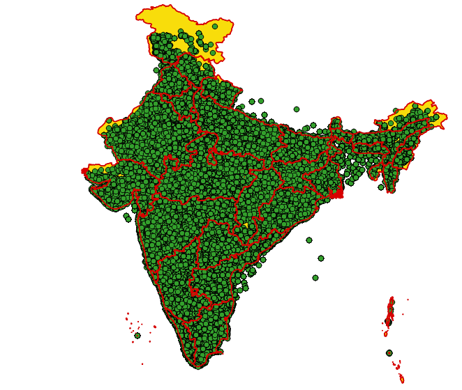
> Attached a visualization sample of geocoded placenames with pincodes
> currently in osm. AFAIK this would be the best free datasource currently
> available.
>
> -Arun
> On Mon, Mar 7, 2011 at 1:33 PM, Ananth Mani
> <ananthar...@reportbee.com> wrote:
>>>
>>>
>>>>
>>>> Counters - Total Pincode available, Total pincode mapped, Total pincode
>>>> pending, 10 Randomly picked pincode that needs inputs.
>>>
>>> We don't have the full list of PIN codes at the moment, which is part of
>>> the problem. But yes, once we have that, this is a definite to-do.
>>
>> Idea of counter is to reflect the current status (like progress) rather
>> than completed status.
>> ~ Ananth
>
>
> --
> j.mp/ArunGanesh
>
-----------------------------------------------------------------------------------
http://blog.dhananjaynene.com twitter: @dnene
j.mp/ArunGanesh
Arun Ganesh
j.mp/ArunGanesh
Arun Ganesh
j.mp/ArunGanesh
Arun Ganesh
> Good point. But re-using the Google Geocoder data will run into licensing
> problems. I'd rather people did this manually, or we used OpenStreetMap like
> Arun suggested.
Really? Even if we used just the latitude/longitude portions? Quite
interesting.
j.mp/ArunGanesh
S Anand
Arun Ganesh
I've pulled the data out in a format compatible with the AppEngine bulkuploader (osm.csv).Comparing that with the GeoNames data, we have 2,790 PIN codes in OSM that are new, and I'll import them today. (Arun, this data is CC-SA compatible, right?)We also 2002 common PIN codes. When I compare the two, some them have significant differences (over 1,000km in some cases). I'm attaching the differences (diff-in-data.csv).Arun (or anyone else), any guidance on why we have these differences? Which one do you think is more accurate?
RegardsAnandOn Mon, Mar 7, 2011 at 7:54 PM, Arun Ganesh <arung...@gmail.com> wrote:
Attached is the osm xml data of all Indian placenames extracted from the openstreetmap database. I recommend exploring the data and attribute tags using josm. For visualizations like what I created you can play with maperitive. Be warned that the data may have inconsistent tags due to various users contributing data. It can be corrected and updated on the osm server using josm (but be very careful and make sure you know what you are doing).The data of interest, if you look into the .osm file is the postal_code tag. I have extracted all nodes with a place attribute, and not all of them have the pincode data.References:http://wiki.openstreetmap.org/wiki/Map_Features - Common osm tag valueshttp://wiki.openstreetmap.org/wiki/.osm - osm xml format documentationhttp://wiki.openstreetmap.org/wiki/Osmosis - command line utility to process .osm data--
j.mp/ArunGanesh
--
j.mp/ArunGanesh
Gautam John
> cc-by-sa 2.0.
Just a point here - the Datameet data set is CC-BY licensed and this
AND is CC-BY-SA licensed. They don't play nicely - you can include AND
in the Datameet set only if the Datameet set is CC-BY-SA licensed too.
S Anand
Arun Ganesh
Only reason I picked CC-BY is because http://www.geonames.org/ is CC-BY and that's where my initial dataset is from. I can convert that to a CC-BY-SA, right?Am tempted not to use CC-BY-SA. Attribution is fine, but forcing others to share alike... commercial use would be restricted.Arun, any chance OSM can be used without ShareAlike?
j.mp/ArunGanesh
Gautam John
http://www.osmfoundation.org/wiki/License/Why_CC_BY-SA_is_Unsuitable
The one way around this is to keep the OSM data set independent of
everything else, display it independently and return changes to OSM as
mandated by the SA license. The other option, is to ask AND if they
can independently license it to data meet under a vanilla BY license.

chaitanya reddy
I might be replying to the old thread. But useful information. We can find the all the pin codes of India here: https://data.gov.in/sites/default/files/all_india_pin_code.csv
Thank you
Chaitanya

Shivaprakash Yaragal

Dilip Damle

Sharad Bhat

Devdatta Tengshe
--
Datameet is a community of Data Science enthusiasts in India. Know more about us by visiting http://datameet.org
---
You received this message because you are subscribed to the Google Groups "datameet" group.
To unsubscribe from this group and stop receiving emails from it, send an email to datameet+unsubscribe@googlegroups.com.
For more options, visit https://groups.google.com/d/optout.

Sandeep Singh
Sharad Bhat
--
Datameet is a community of Data Science enthusiasts in India. Know more about us by visiting http://datameet.org
---
You received this message because you are subscribed to a topic in the Google Groups "datameet" group.
To unsubscribe from this topic, visit https://groups.google.com/d/topic/datameet/21uKP0AzrjY/unsubscribe.
To unsubscribe from this group and all its topics, send an email to datameet+unsubscribe@googlegroups.com.

yamraj....@gmail.com
> As discussed in yesterday's datameet, I've set up a crowd-sourced effort to map PIN codes: http://pincode.datameet.org/
>
>
> It's seeded with 11,000 PIN codes from GeoNames: http://download.geonames.org/export/zip/
>
>
>
> Here are ways you can contribute:
> 1. If you know of any other liberally licensed data sources with the latitude and longitude of PIN codes, let me know (or fork the code and upload it)
>
> 2. Even if you had an authoritative list of post codes and names (without lat/lng -- just the list), that'd be of great help too.
> 3. Any thoughts on how we can merge this with the efforts of hundreds of others doing the same thing are welcome. Hate to overlap effort.
>
>
>
> Regards
> Anand

