adjusting radar based rainfall estimation cordinatte
69 views
Skip to first unread message

R valens
Mar 11, 2020, 6:21:20 AM3/11/20
to wradlib-users
Dear all ,I would like to adjust our radar using gage ,how to put coordinate if i have this coordinate for our radar -2.158470, 30.112970 and other coordinate for our station
| Latitude (-) | Longitude |
| 02°32'59'' | 029°46'21'' |
| 01°42'18'' | 029°19'32'' |
| 02°34'00'' | 029°33'00'' |
| -2.57 | 28.95 |
in this script
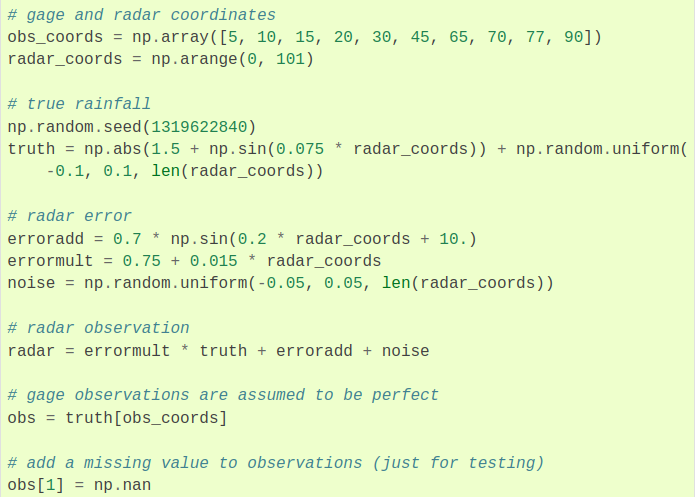
obs_coords = np.array([5, 10, 15, 20, 30, 45, 65, 70, 77, 90])
radar_coords = np.arange(0, 101)
Thanks

Elmer Jeanpierre Lopez Ramirez
Mar 11, 2020, 9:50:06 AM3/11/20
to wradli...@googlegroups.com
Hi,
I guess you are talking about the example of Rainfall Adjustment (https://docs.wradlib.org/en/stable/notebooks/multisensor/wradlib_adjust_example.html). This example was design to explain how to use wradlib functions of adjustment but it's not an example of how you direclty make the adjustment between radar data and gauges. So it's not so simple like changing locations and parameters. Instead of it, you have to built a code. I recommend you see the second part (2-D dimensional case) that is a better example for your goal.
Hope this helps
Elmer Jeanpierre López Ramírez
--
You received this message because you are subscribed to the Google Groups "wradlib-users" group.
To unsubscribe from this group and stop receiving emails from it, send an email to wradlib-user...@googlegroups.com.
To view this discussion on the web, visit https://groups.google.com/d/msgid/wradlib-users/c9f2f5cf-b51d-487f-a60b-b93bc109046a%40googlegroups.com.
R valens
Mar 12, 2020, 6:29:25 AM3/12/20
to wradli...@googlegroups.com
Dear Elmer ,
thanks for your response ,let me take a look on the second part as you recommended me .I will let you know
Regard
You received this message because you are subscribed to a topic in the Google Groups "wradlib-users" group.
To unsubscribe from this topic, visit https://groups.google.com/d/topic/wradlib-users/NQEuk4OAIaU/unsubscribe.
To unsubscribe from this group and all its topics, send an email to wradlib-user...@googlegroups.com.
To view this discussion on the web, visit https://groups.google.com/d/msgid/wradlib-users/CAF3yxhkxOvUGvZwr7RPoFgEJdr0wXV9NC2YBdSBATW6ztN%2B7uA%40mail.gmail.com.
NIZEYIMANA RWAKAGEYO Valens
Radar Data Processing officer
Rwanda meteorology Agency
Tel:0788420134,0725150997
BP:3647 Kigali Rwanda
website: www.meteorwanda.gov.rw

Ambinintsoa Volatiana
May 6, 2022, 9:59:57 AM5/6/22
to wradlib-users
Hello,
I have the same problem and have no idea of the code that you suggest:
So in this example (from Wradlib):
obs_coords = np.array([5, 10, 15, 20, 30, 45, 65, 70, 77, 90])
radar_coords = np.arange(0, 101)
I don't know what is obs_coords and radar_coords,
where can I put the coordonate of my gauges and also the data.
Ambinintsoa Volatiana RAMANAMAHEFA
Reply all
Reply to author
Forward
0 new messages