Not a brilliant forecast

94 views
Skip to first unread message

xmetman

unread,
Jul 25, 2019, 11:45:50 AM7/25/19
to weathera...@googlegroups.com

2019-07-25_163332.jpg


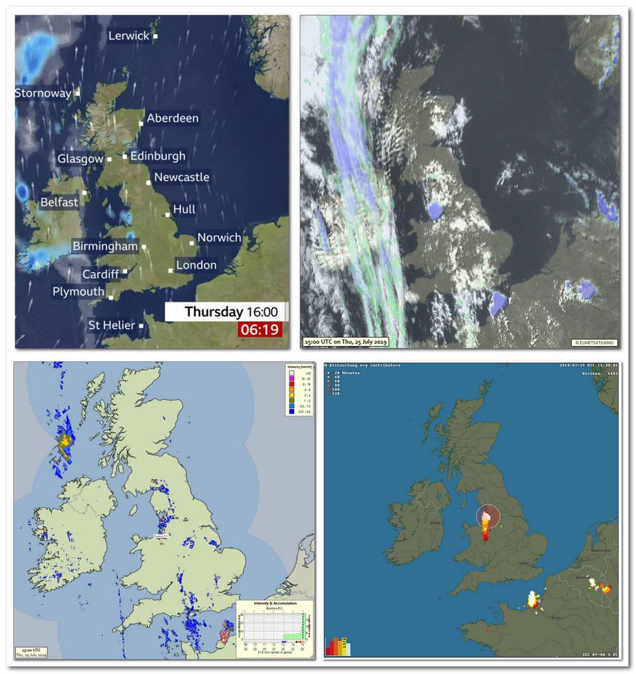
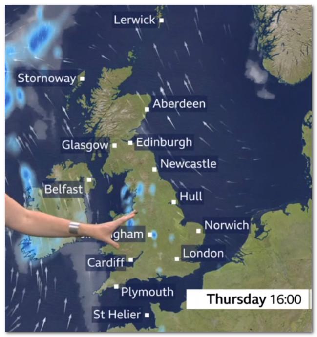
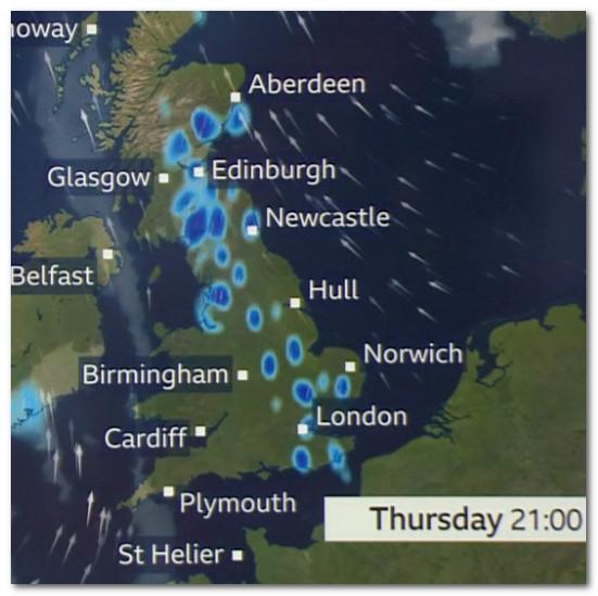
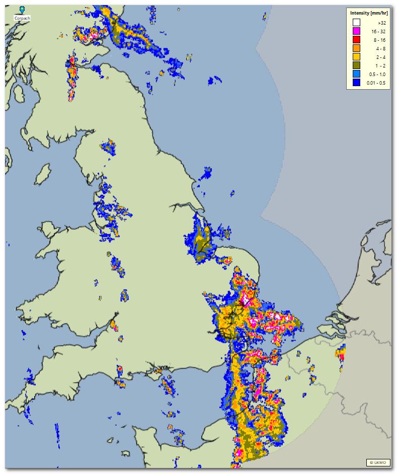
Whatever NWP model Meteogroup are using - and we'll never know unless they but a label at the bottom right hand corner to tell us - did pick up the shower/thunderstorm over Liverpool very well. It may be my eyes, but I don't see much or any in the way of cloud over the bulk of the country, I know it's mainly upper cloud, but it did produce some light showery rain, and it completely missed the big CB and thunderstorm that developed in the Channel. 


It may well have been the warmest July day on record, but to say the forecast was for less than 12 hours in the future, it's not a particular great example of NWP forecasting, but then again because everyone's' eyes where on the mercury rather than the weather, it looks like most people didn't notice or give a damn.


xmetman

unread,
Jul 25, 2019, 12:10:52 PM7/25/19
to Weather and Climate
I notice that even in their 5pm forecast the latest NWP they are using still doesn't generate the thunderstorm that's moving north from the Channel.

2019-07-25_170644.jpg


Julian Mayes

unread,
Jul 25, 2019, 12:28:50 PM7/25/19
to Weather and Climate
Hmm....the main frontal cloud out west is in almost exactly the correct place.   The Ac/ Ac cast elsewhere I guess could be shown by a few blobs but on the national scale surely it would be tricky to represent those small areas accurately. I accept that cloud does not show up as clearly as it ought to. 

Julian  

xmetman

unread,
Jul 25, 2019, 6:14:49 PM7/25/19
to Weather and Climate
Julian

I think it runs a bit deeper than the cloud which as you say doesn't show up clearly at all. The model the BBC and Meteogroup were using clearly hadn't got a handle on the developing thunderstorm over the Channel that I showed at 16 UTC, which continued to develop and move north clipping Kent as it did later in the evening.

2019-07-25_223919.jpg


You must admit that the models view on reality doesn't look too realistic even at 21 UTC. If this large area of medium level instability and embedded CB had been 1° further west then we might have had a dual story of hottest July day ever and flash flooding in east London in the 10 o'clock news tonight. Perhaps the radar is over egging the rainfall but without the hourly rainfall totals I'll have to wait till midnight to find out!

2019-07-25_223836.jpg


xmetman

unread,
Jul 26, 2019, 3:54:52 AM7/26/19
to Weather and Climate
From the rainfall totals it looks like it was...

2019-07-26_085235.jpg


Julian Mayes

unread,
Jul 26, 2019, 6:07:54 AM7/26/19
to Weather and Climate
I ought not to reply to this as it keeps that subject line in a prominent position!  (and yes that storm should certainly have been pointed out one way or another - I don't know if the presenters did  verbally).  Anyway, to add a few totals from the 'extras' list, Cromer had 9mm ovnt and Charsfield (north-east of Ipswich) had 12mm.  Maybe the radar was not quite so misleading after all. Even so, there are often times when I expect to see measurable rainfall from the MO tipping bucket gauges and none or little appears. Isn't it fairly well known that when sites become automated, they become slightly 'drier'? Philip Eden was convinced about that when Hampstead become automated.  

Julian  

xmetman

unread,
Jul 26, 2019, 6:34:13 AM7/26/19
to Weather and Climate
I've changed the title to spare your blushes!

I do appreciate your input to the forum.

I wasn't especially picking on Meteogroup anymore than I do when I criticise the Met Office NWP, but nowadays since Meteogroup won the BBC contact, they are more in the firing line. I'm still of the opinion that they should attribute which NWP model they use in any forecast, it would probably come as a surprise to see just which model was favoured most.


Julian Mayes

unread,
Jul 26, 2019, 7:04:57 AM7/26/19
to Weather and Climate
No problem at all - you are simply being consistent. 

I wasn't blushing, it's the heat.  

Julian 

Paul Knightley

unread,
Jul 26, 2019, 7:27:16 AM7/26/19
to Weather and Climate
The model shown on the BBC forecast is the one chosen to have the best overall 'view' of what is expected to happen - models are typically quite poor at predicting thunderstorm development, especially in these southerly plume set-ups.

For example, on Tuesday evening, ECMWF did much better than the Euro4 and UKV models from the UKMO; yesterday, overall I would say ECMWF did best with the stuff over NW England, but Euro4, in the end, did better for the stuff in the SE.

It's up to the BBC as to whether to label models - but, in the end, it shouldn't really matter to the layperson watching the forecast - it should attempt to reflect the overall forecast position.

Showers/rain can be added/removed - but, of course, confidence needs to be fairly high in order to do this...as the afternoon went on and the storms became more prevalent over N France, so more was added in.

You won't find any model that did brilliantly with the development yesterday.

xmetman

unread,
Jul 26, 2019, 8:03:07 AM7/26/19
to Weather and Climate
Thanks Paul for your comments.
Reply all
Reply to author
Forward
0 new messages