Skip to first unread message

xmetman
May 29, 2019, 4:53:35 AM5/29/19
to Weather and Climate
Pinch of frost - another euphemism that I picked up from the Darren Bett yesterday, along with the use of the word "zone" that seems to have replaced "parts" or "area" with Lucy Verasamy.
I would have thought that a pinch has got to be a bit more than a "touch" but sounds the same as a "nip" to me.
Well there was quite a widespread air frost across parts of the Highlands last night, but as all presenters seem so besotted with the warm day to come on Saturday in the south, you may well have missed it.
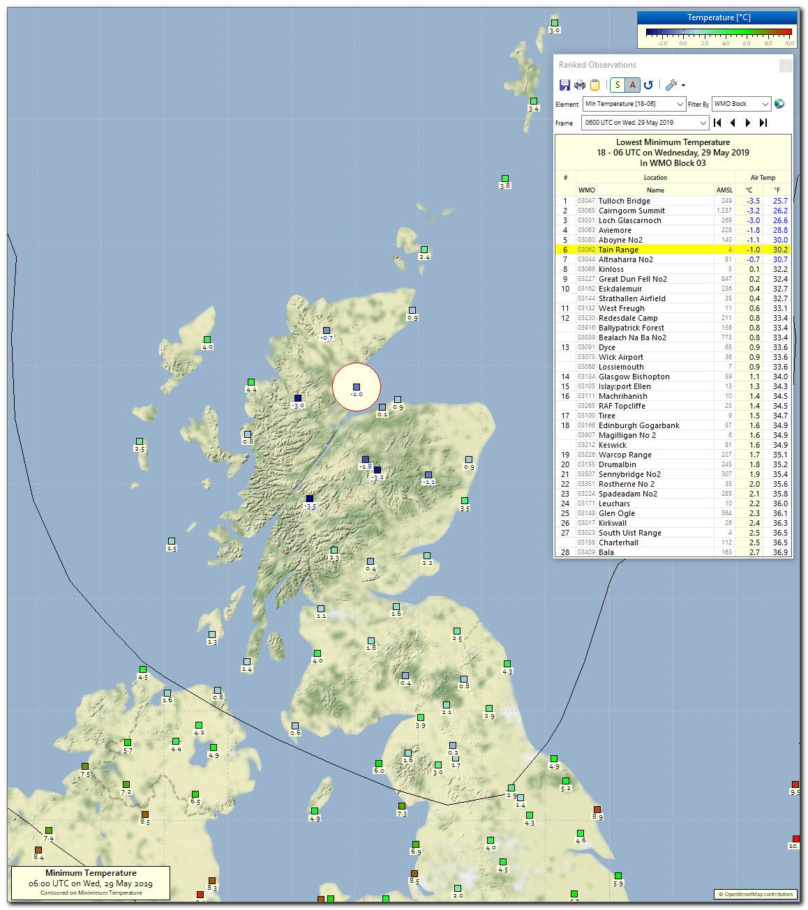
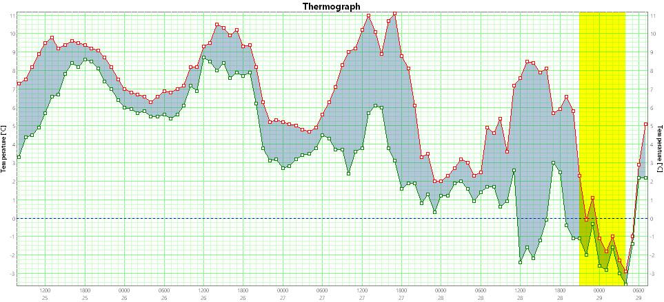
This is the thermograph from Loch Glascarnoch for last night. Even with just over 6 hours of darkness at this time of the year it could still manage a minimum of -3.0°C, some pinch.

Brian Wakem
May 29, 2019, 6:17:38 AM5/29/19
to Weather and Climate
On Wednesday, 29 May 2019 09:53:35 UTC+1, xmetman wrote:
Pinch of frost - another euphemism that I picked up from the Darren Bett yesterday, along with the use of the word "zone" that seems to have replaced "parts" or "area" with Lucy Verasamy.
I sometimes watch old forecasts of significant weather events on Youtube. The old word for zone, parts or area was "districts".

Graham Easterling
May 29, 2019, 6:24:04 AM5/29/19
to Weather and Climate
Well there was quite a widespread air frost across parts of the Highlands last night, but as all presenters seem so besotted with the warm day to come on Saturday in the south, you may well have missed it.
Quite likely. Also, in Penzance - which most people regard as being fairly far south, the MetO forecast max for Saturday has never been above 16C, and is currently 15C, which would make it the coldest day since 14.6C on 9th, the last day to fail to hit 15C. That forecast looks very pessimistic to me even if there's low cloud. It reached 19.0C here on 25th in a NW airstream, but the fact is the high temperatures look like only being in parts of the south, (specifically the London area?)
Graham
Penzance
xmetman
May 29, 2019, 7:01:11 AM5/29/19
to Weather and Climate
Yes, Graham I wasn't quite specific enough!
It's only when you've moved to somewhere completely new, as we did when we moved to Scotland last year, that you realise how you can feel excluded in a weather forecast.
Today's presenters must see a maximum of 27°C in London as much more interesting than 60mm of rain in Fort William, but to be fair I suppose the high temperatures in London will directly affect 10 million people rather than the 20,000 or so in the west Highlands the rain will inconvenience.
What is a bit galling is when they say how it will turn cooler and fresher after Saturday, when that's how it's been for the last couple of weeks in the far north.

Julian Mayes
May 29, 2019, 7:02:36 AM5/29/19
to Weather and Climate
I sometimes watch old forecasts of significant weather events on Youtube. The old word for zone, parts or area was "districts".
Whilst I'm old enough to remember Jan 1987 - and Ian McCaskill - that forecast really seems from another age - in terms of the sober treatment of quite extreme conditions. 'cold enough in all conscience' and the continuiity announcer referring to a 'cold-watch emergency service' on TV the following day. All very impressive. A few years after that I took a group of students around London Weather Centre - and we met Ian at his desk. The students had no idea whether he was being serious or joking, but that's another story.
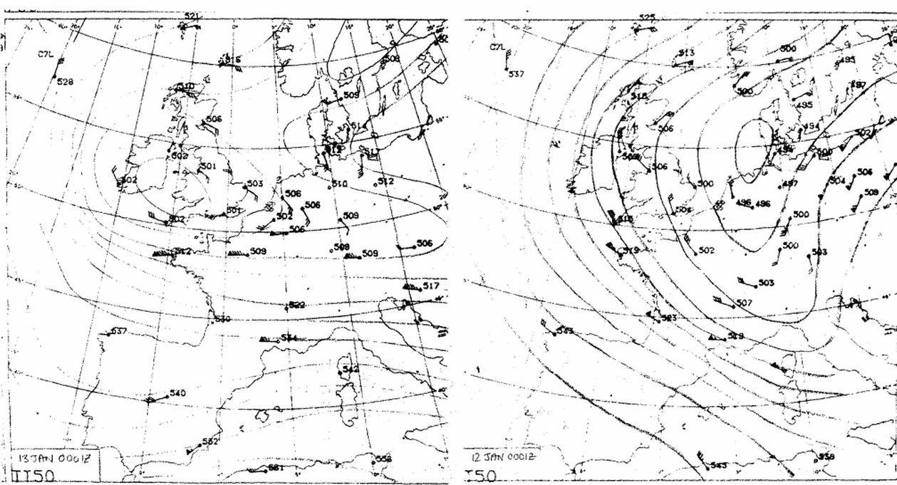
And while on the subject of that remarkable month, and to mark Bruce's return to these parts (welcome back, as others have said), I was struck by the max and min temps of 12 Jan 1987 shown on his site here
...whereas the max temps across southern Britain are so consistent (many places -7 to -8C), why is there one extreme min of -23C in the East Midlands while surrounding sites are around -15C - and the next coldest are in the N of England? In a night of such strong winds, it seems scarcely believable to have such a local cold pocket (sorry, another euphemism!). The snow cover would have been widespread, to say the least.
Julian
Molesey
Surrey
xmetman
May 29, 2019, 7:05:19 AM5/29/19
to Weather and Climate
Yes, I think I can remember the "central northern England" district.
She did mention that tomorrow's front getting stuck in the "central zone", but when I think of zone I can't help thinking about the "twilight" variety.

Tudor Hughes
May 29, 2019, 11:55:42 AM5/29/19
to Weather and Climate
Nobody ever says "a pinch of frost". Nor do people talk about "sharp showers". If you're sharp, pull off, not too far or you'll be flat. Nor does convective cloud "bubble up into the afternoon" as if it were some giant aspirator. This lingo is a patronising insult. Ooh, that's better.
Tudor Hughes

Len
May 29, 2019, 5:54:31 PM5/29/19
to Weather and Climate
We only had a touch of sun here today in Wembury.
I felt quite depraved.
Len Wood
xmetman
May 30, 2019, 4:57:59 AM5/30/19
to Weather and Climate
Julian
Julian Mayes
May 30, 2019, 6:27:13 AM5/30/19
to Weather and Climate
Bruce, thank you for uploading those charts - further evidence for how exceptional that spell was. I still find it slightly surprising that you can get a -23C within a wide zone of minima c -15C when other frost hollows were not that obvious in central England. I've just looked up Caldecott (assuming its the one in Rutland) and it is in a clear frost hollow - where the Eye Brook joins the Welland, just downstream of Eyebrook Res. (I think the P. in Caldecott P. Stn. might stand for pumping station, not power station). It makes me wonder how many frost hollows have never been discovered by any kind of observing network but are well known to local gardeners and farmers.
That's one fewer thing for me to worry about.....
Julian
Molesey
xmetman
May 30, 2019, 7:16:47 AM5/30/19
to Weather and Climate
Julian
I'll have a look at the 13th of December 1981 when I get time and see what MIDAS reveals about stations around Shawbury.
Bruce.
Tudor Hughes
May 30, 2019, 4:45:31 PM5/30/19
to Weather and Climate
Have a look at the even better example of a few weeks later, especially 10 Jan 82, when minima were down to -26°C in Shropshire. My brother, who at the time lived in Wem, recorded a min of -24°C followed by a max of -5°C with a wall-mounted Six's. The following minimum was -21°C so no air mass change. If nothing else this illustrates the extreme shallowness of the cold layer. There is an article in "Weather" about it but short of turning the house upside-down I can't tell you which issue it's in.
Tudor Hughes.
Reply all
Reply to author
Forward
0 new messages