
xmetman
Jun 10, 2019, 7:24:13 AM6/10/19
to Weather and Climate


Brian Wakem
Jun 10, 2019, 7:29:06 AM6/10/19
to Weather and Climate
I'm inside the Amber area. 2.2mm here and I can only see another 2mm maybe on the radar to come.
--
Brian Wakem
Lower Bourne, Farnham, Surrey
Live obs @ 12:28:52 : 12.1C, DP 11.3C, RH 95%, 2.2 mm
xmetman
Jun 10, 2019, 7:35:04 AM6/10/19
to Weather and Climate
I think it maybe from thundery showers that are expected to develop in the wake of the front later today.

Freddie
Jun 10, 2019, 8:02:46 AM6/10/19
to Weather and Climate
On Monday, 10 June 2019 12:35:04 UTC+1, xmetman wrote:
I think it maybe from thundery showers that are expected to develop in the wake of the front later today.
Correct - and coinciding with evening rush hour for maximum impact :-(
The warning commences at 1500 BST and runs through to 2300 BST. Farnham probably affected for the first three hours, but it looks as if the main focus of the activity will be north of Farnham after this time.
--
Freddie
Dorrington
Shropshire
115m AMSL
http://www.hosiene.co.uk/weather/
Stats for the month so far: https://www.hosiene.co.uk/weather/statistics/201906JUN.xlsx
Freddie
Dorrington
Shropshire
115m AMSL
http://www.hosiene.co.uk/weather/
Stats for the month so far: https://www.hosiene.co.uk/weather/statistics/201906JUN.xlsx

Dave C
Jun 10, 2019, 9:33:51 AM6/10/19
to Weather and Climate
As usual, with rain, I'm not that confident of the prediction for our region. Any showers will have to be generated in situ I guess as all of the continuing intense rainfall on the radar at the moment is tracking well west of London, more central southern and south midlands. Mind, I've had 15mm so far which is a positive deluge here after months of dry weather!
Be interested to see who does get 50+mm in the S.E..today.
Dave C
Jun 10, 2019, 10:21:56 AM6/10/19
to Weather and Climate
......... although now heavy echoes appearing leaving N.France - perhaps this is the source.
Freddie
Jun 10, 2019, 10:29:43 AM6/10/19
to Weather and Climate
On Monday, 10 June 2019 15:21:56 UTC+1, Dave C wrote:
......... although now heavy echoes appearing leaving N.France - perhaps this is the source.
Those particular cells are unlikely to be the source - but the unstable air in which they developed is moving into the SE, and you should see home-grown cells developing. They will be the source.

Julian Mayes
Jun 10, 2019, 11:37:33 AM6/10/19
to Weather and Climate
It took a while to develop but it certainly has this afternoon south and sw of London and it was the frontal band that did it - and still is doing so - I should imagine over Brian's house right now! Hvy showers over Kent certainly look interesting for this evening. I've not seen rainfall intensities like this over Surrey since well back in last year. I'm still slightly surprised MO went straight for an amber. The darkest afternoon I can remember for many months though and the lower lying part of my road mostly under water - a sure sign of hvy rain.
Clearly a response to my months of drought-grumbling!
Julian
Molesey, Surrey
xmetman
Jun 10, 2019, 11:50:13 AM6/10/19
to Weather and Climate
Totals starting to mount up now with the odd green pixel (32-40mm) around Guilford and south Lincolnshire.

Keith (Southend)
Jun 10, 2019, 11:56:40 AM6/10/19
to Weather and Climate
I saw that, but when I looked at the rainfall radar and it was dry ow here, I decided to treat some lawns this afternoon. It still hasn't rained since about 11:30am.
Keith (Southend)
Brian Wakem
Jun 10, 2019, 11:59:43 AM6/10/19
to Weather and Climate
On Monday, 10 June 2019 16:37:33 UTC+1, Julian Mayes wrote:
It took a while to develop but it certainly has this afternoon south and sw of London and it was the frontal band that did it - and still is doing so - I should imagine over Brian's house right now!
Well it's certainly pepped up but the really bright echoes missed me by about 10 miles (N). Max rain rate so far here is 13.2mm/hr, currently 8mm/hr. 8.8mm total but looks like quite a bit to come.
Live obs @ 16:59:18 : 10.4C, DP 9.8C, RH 96%, 8.8 mm
Julian Mayes
Jun 10, 2019, 12:27:19 PM6/10/19
to Weather and Climate
1600h obs: Not often you find that 7 out of the 10 observing sites within the M25 are below 10C on a June afternoon. (cheating slightly by including Wisley which is a few hundred metres outside).
I wondered why my central heating had come on and very welcome it is too.
Julian
Molesey
xmetman
Jun 10, 2019, 12:41:23 PM6/10/19
to Weather and Climate


Graham Easterling
Jun 10, 2019, 1:40:39 PM6/10/19
to Weather and Climate
Not often you find that 7 out of the 10 observing sites within the M25 are below 10C on a June afternoon.
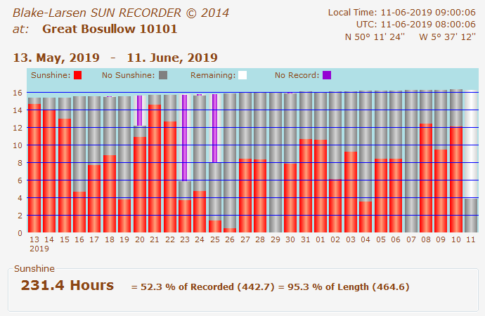
I thought today's maximum of 15.9C was low, 3C lower than yesterday, now I'm feeling slightly smug! (15.8C @ Lands End, 15.5C @ Bosullow, 4 miles NW of Penzance on the moors) .
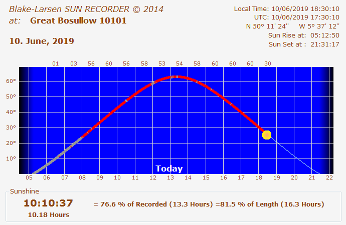
The Lands End peninsula just missed the downpours that affected the south coast, though some big showers drifted off LIzard SW across Mounts Bay in a rather photogenic way.
Some lovely sunshine to end the day.
Graham
Penzance
xmetman
Jun 10, 2019, 2:43:07 PM6/10/19
to Weather and Climate

Brian Wakem
Jun 10, 2019, 3:06:59 PM6/10/19
to Weather and Climate
22.6mm here. Still some light rain but brighter echoes on the way so I might make an inch.
Live obs @ 20:06:35 : 9.8C, DP 9.3C, RH 97%, 22.6 mm

Tudor Hughes
Jun 10, 2019, 4:14:38 PM6/10/19
to Weather and Climate
Max this afternoon was 10.6°C, the lowest June max I have observed in 36 yrs recording. Also, at 1805Z, there was a loud crack of thunder but no lightning seen.
Tudor Hughes, Warlingham, NE Surrey, 557 ft, 170 m.
Brian Wakem
Jun 10, 2019, 5:32:54 PM6/10/19
to Weather and Climate
Now 28mm with plenty more to come by the look of it. This is currently my 3rd wettest day ever (since Aug 2013).
The top 2:
2013-12-23 37.4
2016-06-23 30.8
I don't think 37.4 can be reach before midnight (I record midnight-midnight) as the rain isn't heavy enough but I think it take position 2.
Live obs @ 22:32:05 : 10.4C, DP 9.9C, RH 97%, 28.0 mm

Len
Jun 10, 2019, 6:16:40 PM6/10/19
to Weather and Climate
That 31 mm for Plymouth is weird.
20.8 mm in my gauge here 10 km away in Wembury.
Just shows how localised the heavy downpours can be in such a synoptic situation.
Len
Wembury
Tudor Hughes
Jun 10, 2019, 7:41:40 PM6/10/19
to Weather and Climate
I've just had a quick look at the bottle in my gauge and I'd say there's at least 55 mm in there. In addition there is 17 mm measured Monday morning, so probably 80 mm for the entire event unless there's more. The temperature has been rising slowly since about 19Z.
Dave C
Jun 10, 2019, 7:56:39 PM6/10/19
to Weather and Climate
Is this a case of "... if only it were January", with a blocking Icelandic high.
Dave C
Jun 10, 2019, 7:58:11 PM6/10/19
to Weather and Climate
22.3mm total here in S.Essex. A lot for us but less than predicted.
xmetman
Jun 11, 2019, 4:14:55 AM6/11/19
to Weather and Climate
xmetman
Jun 11, 2019, 4:30:31 AM6/11/19
to Weather and Climate
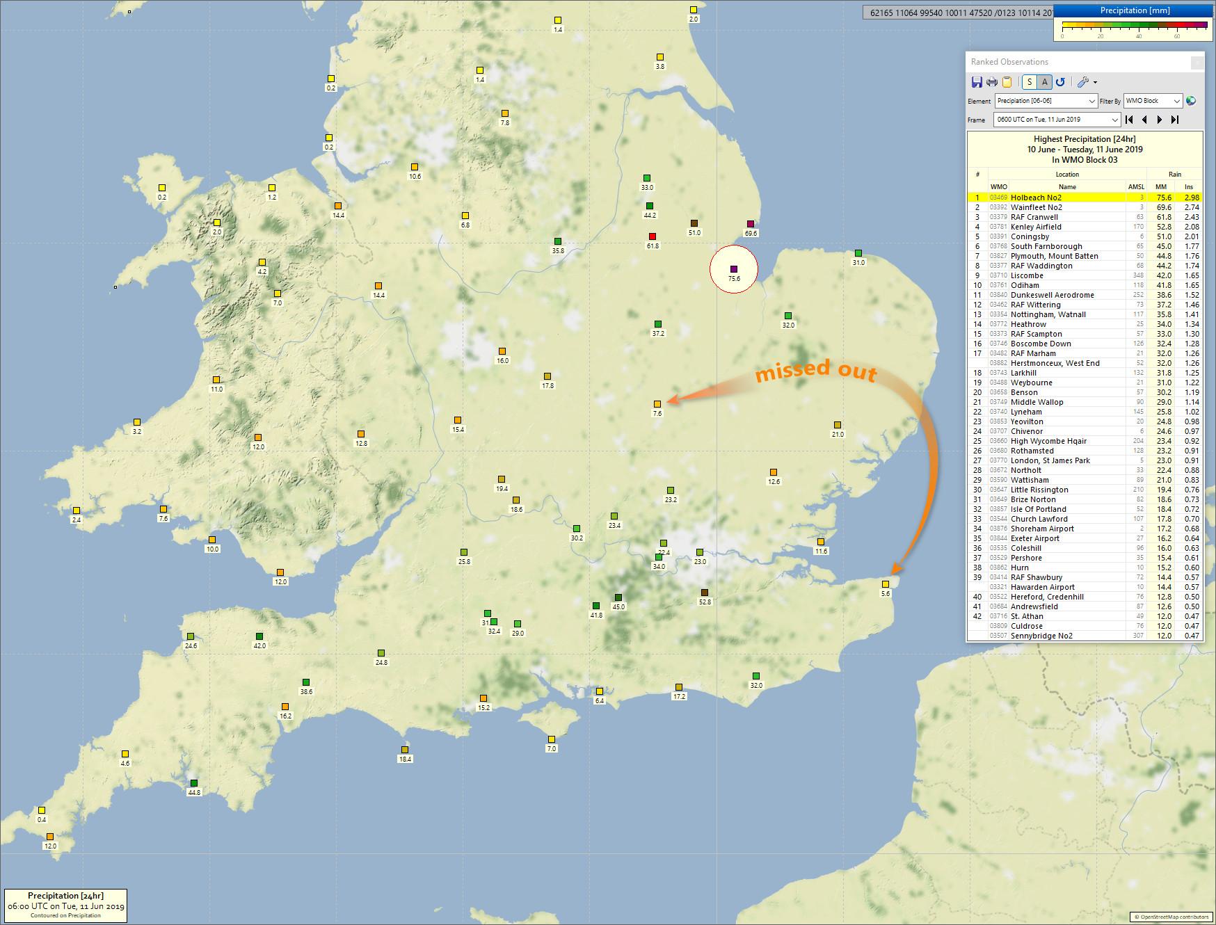
All in all the warnings from the Met Office where of the right magnitude even if the area for the amber warning was more to the SW of London.
The totals around the Wash were quite exceptional and I think no one expected 75mm over an extended period and not just 24 hours in this region.
In the TV forecasts that I listened to yesterday the presenters were trying in words to describe the orientation of the front and where it lie.
- Northern England
- North East England
- The Midlands.
- Eastern England
- East Anglia
Not one person in the forecasts I listened to mentioned a county - more especially Lincolnshire which is a pretty big county - and yesterday was very wet.
Of course it's probably just another day at the office for these presenters and who cares if Lincolnshire not strictly in North East England.
xmetman
Jun 11, 2019, 4:43:11 AM6/11/19
to Weather and Climate
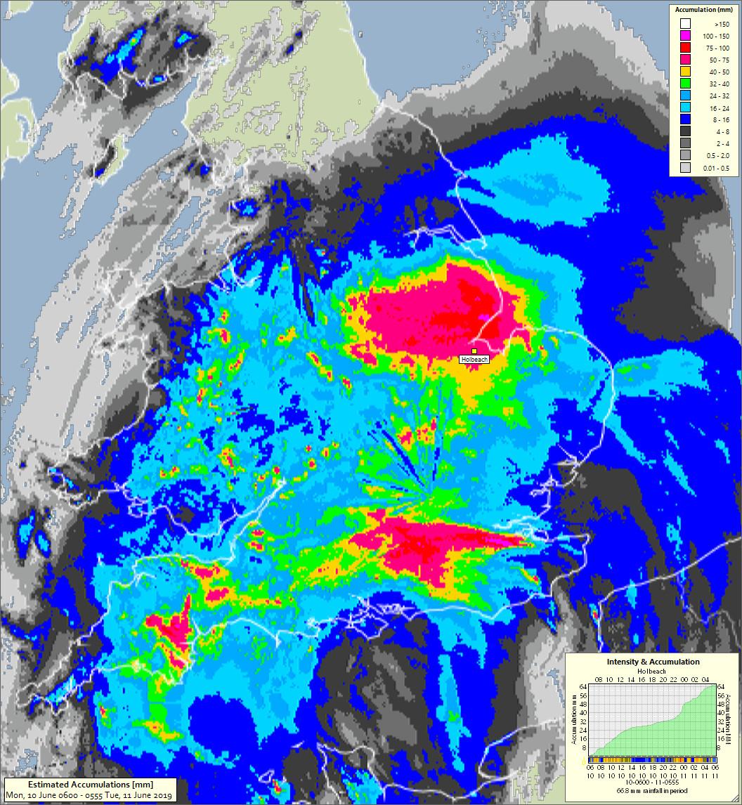
When I produce these estimates because I use 5 minute low resolution radar images from the Met Office.
I make an assumption that it will rain at that intensity (the colour of the pixel) for the full 5 minutes.
In showers that won't always be realistic, so I have three settings go guess at a five minute total low,medium and high.
By default I use medium, but for this chart I used high to try and capture the larger totals.
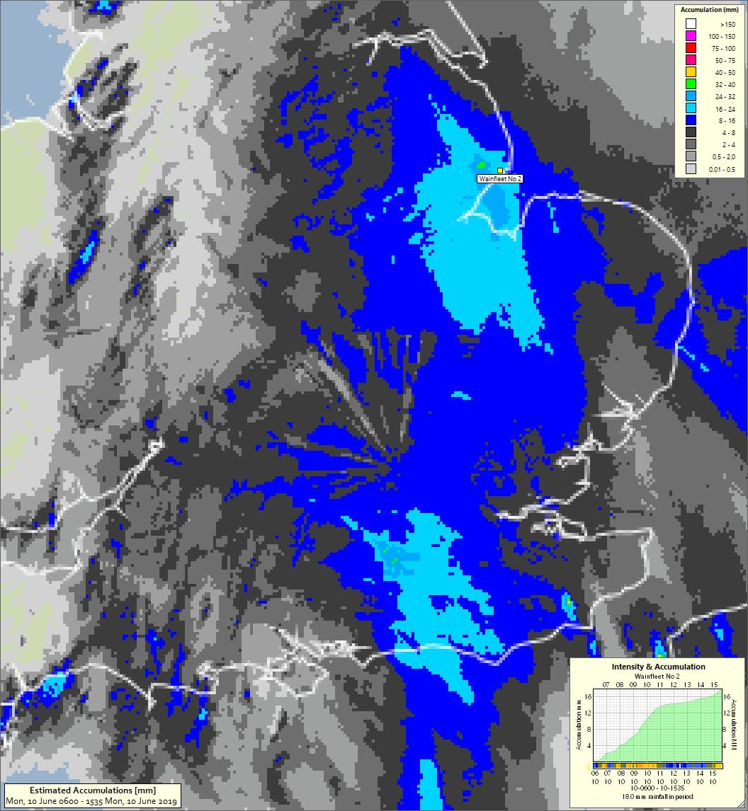
Even so the 66.8 from Wainfleet is still a bit low - and don't ask about the dry slot over Wyton!
Take it with a pinch of salt it is an 'estimate' after all.
Graham Easterling
Jun 11, 2019, 4:57:52 AM6/11/19
to Weather and Climate
I find these charts interesting Bruce.
Quite sunny in Cornwall yesterday away from those south coast downpours set off by the south coast sea breeze meeting the developing N wind. In the far SW sunny even over the moors, where the rain on your chart occurred in the early hours of today
Nearest downpour at Culdrose, which looked impressive from Penzance. Interesting feature that gave the downpour in Plymouth.
Now 11.5C rather wet & windy in Penzance.
Graham
Penzance
Julian Mayes
Jun 11, 2019, 6:02:39 AM6/11/19
to Weather and Climate
Thanks for the map Bruce. My 09-09 total was 50.4mm. I have lost some of my early daily totals (on old PCs) but I think that will be my highest 09-09 total since autumn 2000. My highest was 55mm in September 2000. We did well here during the day (i.e. wet) but it was the evening convergence line that ran west from Rochester over the North Downs that really did it. I see from the EA site that a few streams in SE London reached there highest ever levels yesterday evening, though they no longer tell us the length of record at their gauging stations, which is pretty useless.
I'm looking at the frequency of high daily and 2-day totals in the SE at the moment and was astonished until y'day at how few there had been recently. The situation is not THAT different to the mid-September floods of 1968 - I am sure that would have had a similar convergence line from the Thames Estuary, though of course that event lasted a full 2 days and gave 150-200mm in places.
Julian
Molesey
Surrey PS I shall stop bleating about drought for a few weeks.
Brian Wakem
Jun 11, 2019, 6:03:53 AM6/11/19
to Weather and Climate
35.2mm in the here, plus 0.2mm after midnight.
The stream in my garden only rose about 10 inches. If that much had fallen on saturated ground it would have risen 3 or 4 feet at least.
Live obs @ 11:02:21 : 14.3C, DP 12.7C, RH 90%, 1.2 mm
xmetman
Jun 11, 2019, 6:47:42 AM6/11/19
to Weather and Climate
Yes an interesting situation, and another pulse coming out of the continent to affect the NE Coast of England and SE Scotland later tomorrow.
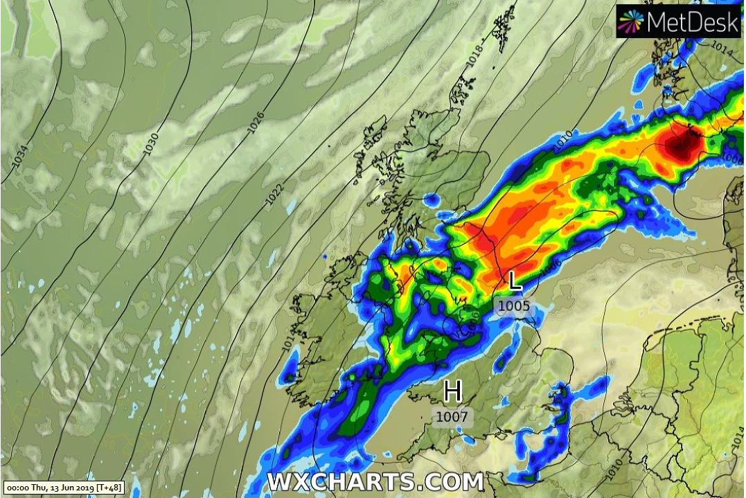
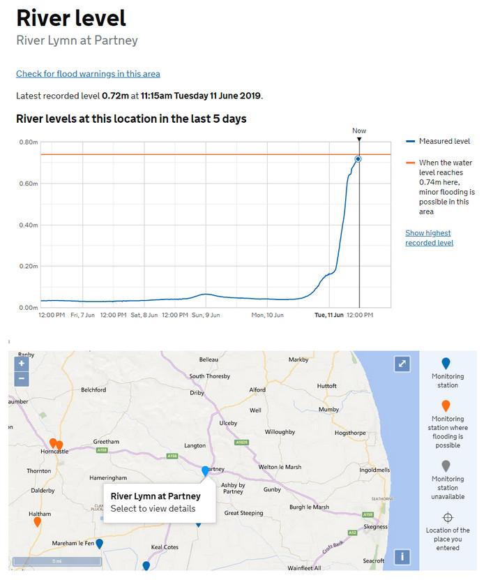
The larger rivers in the south of Lincolnshire seem to have taken it in their stride - probably because there were already low - and the rain area has now moved north and started to fragment a bit.
Graham Easterling
Jun 11, 2019, 11:02:44 AM6/11/19
to Weather and Climate
That very cool air now seems to be over Cornwall. Between 11 & 12C all day so far. May end up a new June record low max (since 1992.) unless it warms up overnight. My lowest ever June max being 13.0C. Last Friday came close at 13.2C, and that was just before the observation time of 09:00 the following day, the same thing might happen again.
A big change from the sunshine, light winds, & 18.9C of Monday.
Graham
Penzance
Dave C
Jun 11, 2019, 11:24:05 AM6/11/19
to Weather and Climate
I was driving N-S down the A1 yesterday morning and the rain was very patchy. Sometimes torrential, other times lighter as reflected in those figures. Lincolnshire did get a special mention in one of the forecasts I heard though.
Freddie
Jun 11, 2019, 11:26:29 AM6/11/19
to Weather and Climate
On Tuesday, 11 June 2019 16:02:44 UTC+1, Graham Easterling wrote:
That very cool air now seems to be over Cornwall. Between 11 & 12C all day so far. May end up a new June record low max (since 1992.) unless it warms up overnight. My lowest ever June max being 13.0C. Last Friday came close at 13.2C, and that was just before the observation time of 09:00 the following day, the same thing might happen again.
It's up in Shropshire too - max of 9.6 today. Temperature has been pretty consistent since 1800z yesterday - max of 9.9 and a min of 8.7 in that period. No diurnal variation, so pretty thick cloud and bucketloads of evaporational cooling :-( Looks a bit brighter and warmer for tomorrow - models are suggesting a max of 15 or 16 which will be lovely after today, but still 3 degrees below average!
Dave C
Jun 11, 2019, 11:29:38 AM6/11/19
to Weather and Climate
Forecast was pretty good really. It was probably out by about 80 miles to the south and west hence much of Suffolk and Essex being drier than expected, although here in the south of that region 22mm is quite useable.
Tudor Hughes
Jun 11, 2019, 11:56:20 AM6/11/19
to Weather and Climate
The total here was 58.3 mm, a June record starting 1983. In addition I measured 17.4 mm on Monday morning from rain that had started in earnest at about 3 a.m. BST. The total for the whole event was therefore 75.7 mm. At no time could the rain be called torrential; it was just "continuous heavy". The ground absorbed the water very well and the road runoff from the field at the back was fairly restrained. I have seen much greater flows from smaller falls. The soil here is about 30 ft of clay over chalk.
Tudor Hughes, Warlingham, Surrey, 557 ft, 169 m
Reply all
Reply to author
Forward
0 new messages