Rain at Greenland Summit.

60 views
Skip to first unread message

Pete B

unread,
Aug 18, 2021, 4:33:46 PM8/18/21
to Weather and Climate

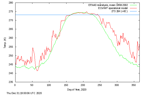
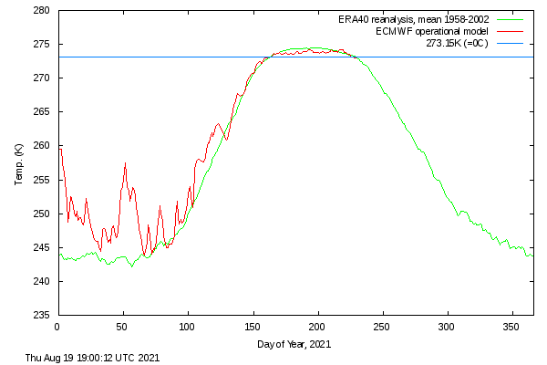
As would be expected from the recent upper air temperature forecasts for the mid August period and the 16/8/21 obs, rain fell at the Greenland Summit station with air temperatures just above freezing for several hours a couple of days earlier on 14/8. This was the day of maximum melt area during the warm air event.

https://nsidc.org/greenland-today/2021/08/rain-at-the-summit-of-greenland/

Let's just hope this doesn't become a more regular event. I would have thought that similar pressure distributions must have occurred many times before without such high temperatures but as warming continues, then maybe it will.

The melt area is now decreasing by the day but still well above the interdecile range for this time of year. Even 2012 and 2019 had much lower melts by now.

Len W

unread,
Aug 19, 2021, 2:46:05 PM8/19/21
to Weather and Climate
Interesting to see the Arctic sea ice extent decrease has slowed down eralier this year compared with last.

Arctic sea ice.png

Pete B

unread,
Aug 19, 2021, 6:42:05 PM8/19/21
to Weather and Climate
It'll be interesting to see what the next week or so brings up there & whether we get the sudden downturn that happened last year around this time. The mean temperature north of 80 degrees seems a little lower than last year and so far seems to be following the trend down rather than the lingering higher temperature of last year which probably contributed to the late start to the autumn freeze.


meanT_2020.png meanT_2021.png

Also, large Greenland melting seems to coincide with ever lower Arctic ice minima years (2005, 2007, 2012 & 2019) but this year, unless there is a big downturn in the next month, that may not happen this time.
Reply all
Reply to author
Forward
0 new messages