
Smartie
Jan 2, 2017, 8:31:10 AM1/2/17
to Weather and Climate
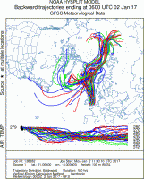
The cold air outbreak and arctic front on New Year's Day was a pretty feeble affair. 180 hr back trajectories (NOAA READY Hysplit model) from 00UTC 2 Jan suggests the boundary layer airmass behind the cold front originated over northern Siberia and the East Siberian Sea, travelling over the Barents and Norwegian Seas before moving over the UK. Air parcels seem to have significantly warmed in the latter half of the journey, unsurprising given the low arctic sea ice coverage , relatively ice-free Barents-Kara Sea and exceptionally warm arctic surface temperatures this winter. Parcels originating in the western Atlantic appear to have descended from aloft, likely associated with descending dry air from the UTLS region (seen clearly in Airmass imagery, not shown and NWP output, see below).
The arctic front which formed on the leading edge of this polar airmass mostly produced rain over England, however there were reports of sleet mixed in. Radar imagery and AWS observations indicate the presence of a distinct cold front with heavier rain embedded in a wide frontal rainband of lighter precipitation. Bernard Burton's AWS at Wokingham has a particularly good record -
http://www.woksat.info/cs/ejsgr170101.gif
of an ana-cold frontal passage at around 14Z with a hydrostatic pressure rise, sharp wind shift and initial 2-3C temperature drop. There was also a marked increase in mean wind and gusts behind the front.
A cross-section along -1W through the the 3km GFS-WRF model domain at 18Z 1 Jan shows the surface front moving south (here located at x=~160km) with clear ana-front characteristics although the colder, low theta w (green isopleths), air of ~2C is much further north.
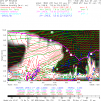
There is a low level wind max, directly behind the SCF with horizontal windspeeds (red contours) reaching 18 m/s at ~750m. Some of this higher momentum air was clearly being mixed down in downdraughts and/or turbulence in the weak gravity/density current-like flow. The wet-bulb zero freezing level (cyan dashed isopleth) drops immediately at the SCF, but does not reach the surface. Diagnosed total latent cooling from the model (dashed contour at -0.25 K/hr) is at a maximum immediately to the rear of the SCF presumably due to heavier precipitation evaporating or sublimating in the lower theta w air behind the front.
Poleward of the front there is a marked tropopause depression with the 2 PV isopleth descending to 4km, consistent with airmass imagery. The low-level 2 PVU max on the front itself is due to latent heat release in the sharp forced ascent characteristic of ana-fronts.
The arctic front which formed on the leading edge of this polar airmass mostly produced rain over England, however there were reports of sleet mixed in. Radar imagery and AWS observations indicate the presence of a distinct cold front with heavier rain embedded in a wide frontal rainband of lighter precipitation. Bernard Burton's AWS at Wokingham has a particularly good record -
http://www.woksat.info/cs/ejsgr170101.gif
of an ana-cold frontal passage at around 14Z with a hydrostatic pressure rise, sharp wind shift and initial 2-3C temperature drop. There was also a marked increase in mean wind and gusts behind the front.
A cross-section along -1W through the the 3km GFS-WRF model domain at 18Z 1 Jan shows the surface front moving south (here located at x=~160km) with clear ana-front characteristics although the colder, low theta w (green isopleths), air of ~2C is much further north.
There is a low level wind max, directly behind the SCF with horizontal windspeeds (red contours) reaching 18 m/s at ~750m. Some of this higher momentum air was clearly being mixed down in downdraughts and/or turbulence in the weak gravity/density current-like flow. The wet-bulb zero freezing level (cyan dashed isopleth) drops immediately at the SCF, but does not reach the surface. Diagnosed total latent cooling from the model (dashed contour at -0.25 K/hr) is at a maximum immediately to the rear of the SCF presumably due to heavier precipitation evaporating or sublimating in the lower theta w air behind the front.
Poleward of the front there is a marked tropopause depression with the 2 PV isopleth descending to 4km, consistent with airmass imagery. The low-level 2 PVU max on the front itself is due to latent heat release in the sharp forced ascent characteristic of ana-fronts.
Reply all
Reply to author
Forward
0 new messages