Skip to first unread message

Graham Easterling
Feb 16, 2022, 4:07:08 AM2/16/22
to Weather and Climate
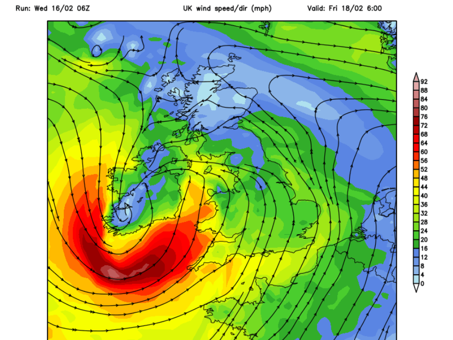
The latest GFS run shows this for Bude (XCWeather's windiest spot in the UK at that time)


A mean speed of 61mph & gusts >90mph.
As I mentioned elsewhere, looks like the 1st major event for Cornwall since 2014.
Due to the fact that the storm won't be sitting over the Atlantic, but dashing across the UK, the significant swell height is very unlikely to match the 30-40' seen in 2014, still very, big & extremely dangerous conditions on the way.
For Sennen
Graham
Penzance
Graham Easterling
Feb 16, 2022, 6:22:33 AM2/16/22
to Weather and Climate
Hurricane F12 to the south of Ireland 06:00 (GFS 06:00 run)
Some big waves, probably short period, which means they won't refract too much, and Perranporth should be OK. Might be some wave setup surfing up the river at Bude.
Porthleven will be packed early Friday morning. Perhaps even the press, telling people that idiots are standing close to the sea, reporters must be immune to the danger and are therefore allowed.
Graham
Penzance.

jack.h...@gmail.com
Feb 16, 2022, 7:23:40 AM2/16/22
to Weather and Climate
Are Storm Cones like this (my picture from circa 1957 - Great Yarmouth) still used?

My dad was a reporter so I presumed that his 18 year old son would also be immune to the danger.
Jack
Graham Easterling
Feb 16, 2022, 10:52:53 AM2/16/22
to Weather and Climate
Yes they are, they are still used at nearby Porthleven.
A number of the National Coastguard Institute stations display them, such as at Polruan in Cornwall.
Graham
Penzance

Ashley haworth-roberts
Feb 16, 2022, 1:28:15 PM2/16/22
to Weather and Climate
I'm not sure that Storm Dudley is quite living up to billing. Whereas I think Storm Eunice probably will. The billing being that it will be one of the most devastating windstorms (with copious rain and snow and likely coastal flooding) to hit the British Isles since the Burns' Day storm in January 1990.
Message has been deleted
Graham Easterling
Feb 17, 2022, 8:25:24 AM2/17/22
to Weather and Climate
It's looking serious now for Perranporth & Bude. St Ives faces east so it's relatively OK, though there could be overtopping around the harbour as there will be some big wave setup surges. Properties on Porthmeor beach are at risk but they are mainly 2nd homes claiming a fake rate rebate,, so . . .!
I wouldn't like to be in Mullion, Porthleven or Marazion either. Penzance & Newlyn face E-SE so are protected to a degree.
The wind may well be the most serious issue, not the sea, unusual for N & W Cornwall. This is because the storms fast movement, and the fact the storm reaches maximum intensity over the UK not when it's sitting in mid Atlantic, means the swell height won't be that exceptional. It was bigger than the currently forecast heights on at least 3 occasions in 2014, and a good deal bigger in March 2008, when the significant wave height hit 13 metres at Sevenstones, just off Lands End. The largest sets around 50% bigger. Worth a look, the biggest sea in living memory according to Terry (the coxswain of the Sennen lifeboat) & John Chappell, who is involved with NCI Gwennap Head & runs the Lands End weather station. Click image for high res version
Current significant wave height forecasts for Sevenstones 8-10m peak tomorrow morning. 11m has a 5 year return period. But the wind . . .
. . and Winter's been so benign here so far.
Graham
Penzance
Graham Easterling
Feb 18, 2022, 8:27:14 AM2/18/22
to Weather and Climate
A classic examples of reporters saying don't do what I'm doing.
As expected, the swells haven't been that big so far, the depression formed too late, though they are building now, up to 28' at Sevenstones. This evenings high tide might be much more interesting. As the swells are locally generated the period is fairly small, so they are not refracting much. As a result, it's relatively calm (as far as the sea's concerned) here in Penzance in the offshore wind
As the waves have not been that spectacular, it's all rather a blown out mess rather than huge breaking swells - very disappointing to be honest, very few wave watchers at Sennen Just as well as the roof blowing off the lifeboat house into a crowd of wave watchers might have had very unfortunate consequences.
There were people inside the lifeboat house, all OK.
Windwise max gust 82mph sat Lands End, so not exceptional for the location. A sheltered wind direction for Penzance, my maximum gust 58mph, my record is 80mph. Conditions much worse along the north coast, and conditions seem to got more severe to the east as the depression continued to deepen.
Graham
Penzance
jack.h...@gmail.com
Feb 18, 2022, 12:43:52 PM2/18/22
to Weather and Climate
A classic examples of reporters saying don't do what I'm doing.
Indeed. But the comments section after that video has this classic:
"My thoughts and prayers go out to her family. "
Clearly nobody had spoken to God before this one (below):
Jack
jack.h...@gmail.com
Feb 18, 2022, 1:28:39 PM2/18/22
to Weather and Climate
I knew Polruan / Fowey quite well some 15 - 20 years ago when my
then sister-in-law had a holiday home in Polruan. We would stay quite
regularly,
Yes, OK Graham, a second home.
But the lady, HW, was a hardworking, quite affluent, professional who
must almost single-handedly have kept the Fowey economy going.
I
visited that enthusiasts' coastguard lookout. I never quite saw the
point except as an interesting hobby. It wasn't always manned so a
small craft going out to sea wouldn't necessarily be logged coming back
into the river. But they insisted that they were providing a valuable
service. Video recording (maybe they do these days) would have been far
more reliable and potentially useful.
Jack
Graham Easterling
Feb 18, 2022, 3:22:00 PM2/18/22
to Weather and Climate
I think the point of NCI lookouts isn't so much the logging of boats going in and out, though it's the sort of thing that the enthusiasts who run them love to do, it's the spotting of incidents at an early stage.
They are enthusiastic volunteers, but so are the lifeboat crews, very similar, and often the same, people.
An archive of some Gwennap Head events recorded here https://www.nci.org.uk/stations/incidents-and-news-archive.
The local knowledge, enabling the warning of somebody who is heading into trouble, is also invaluable.
Talking of Gwennap Head, it currently holds the MetO England wind speed record of 118mph on December 15 1979. Has that been beaten by the Needles today?
Graham
Penzance
Ashley haworth-roberts
Feb 18, 2022, 6:33:33 PM2/18/22
to Weather and Climate
The Met Office thinks so:
Reply all
Reply to author
Forward
0 new messages