Skip to first unread message

Stephen Davenport
Sep 7, 2017, 12:30:59 AM9/7/17
to Weather and Climate
At 01:35 EDT / 05:35 UTC on September 6th, the VIIRS instrument on board the NOAA/NASA Suomi NPP satellite captured Irma directly over Barbuda with sharply-defined eye and strong surrounding convection with tropospheric gravity waves radiating out from the eye and meso-vortices within the eye over Barbuda. This (courtesy of CIMMS)image was taken in the Day-Night Band with excellent visible night imagery thanks to a full moon.


This (below) is a few hours later at about 0700 EDT / 11:00 UTC September 6th as Irma approached Anguilla: a geocolor image from GOES-16, courtesy of NOAA and the Cooperative Institute for Research in the Atmosphere (CIRA). This experimental geocolor imagery enhancement displays satellite data in different ways depending on whether it is day or night; so as this was captured around dawn with a west-east transition from night to day it blends both.

Stephen
Indianapolis IN

Jack Frost
Sep 7, 2017, 9:50:02 PM9/7/17
to Weather and Climate
I see the NHC forecast now has Irma moving over Florida, as opposed to mostly over water to the east. It's been interesting to see the model predictions flip-flopping east and west with each run, though it must be said the Met Office forecast has always been firm on Irma moving over Florida.
Stephen Davenport
Sep 8, 2017, 12:47:33 AM9/8/17
to Weather and Climate
I wouldn't say that models have been flip-flopping at all. That phrase would be something far more contradictory than we have seen. In fact they have been very consistent for many days on the hard right turn after passing between Cuba and the Bahamas, a path which has also been very consistently indicated; and so far the track forecast by the NHC and median of the models/ensembles has verified extremely well. During the last couple of days or so there have been nuanced variations on whether Irma's eye will travel up the spine of Florida or scrape the east coast of the state. That's not much difference at all several days before the event.
We'll wait to see how well it verifies but as long as something entirely unexpected does not happen then the models, the NHC and other outlets have given very good (and life-saving) advice well in advance. The question right now and for the last couple of days seems not be whether this will be devastating for Florida (and potentially Georgia and the Carolinas) but how widespread the devastation could be - the track straight up the guts of Florida implying even worse for the west of the peninsula than a slightly more eastern path.
We'll wait to see how well it verifies but as long as something entirely unexpected does not happen then the models, the NHC and other outlets have given very good (and life-saving) advice well in advance. The question right now and for the last couple of days seems not be whether this will be devastating for Florida (and potentially Georgia and the Carolinas) but how widespread the devastation could be - the track straight up the guts of Florida implying even worse for the west of the peninsula than a slightly more eastern path.
Stephen
Indianapolis IN
Jack Frost
Sep 8, 2017, 1:52:45 AM9/8/17
to Weather and Climate
Well maybe flip flopping was the wrong term - I mean going from the eye over land, to the eye out to see and much less damaging winds for Florida, and back again. Only tens of kilometres difference, but vital in terms of damage.
I also noticed that some models differed wildly from the usual MO, GFS, ECMWF output. I can't remember the names of these models, but if they are as hopeless as they appear from their tracks in this case (and from their reputation amongst people on other weather forums) then why are they even included in comparisons? And, what are they used for in general? Something more mundane? Why can't they track hurricanes?
Stephen Davenport
Sep 8, 2017, 9:05:56 PM9/8/17
to Weather and Climate
On Friday, September 8, 2017 at 1:52:45 AM UTC-4, Jack Frost wrote:
Well maybe flip flopping was the wrong term - I mean going from the eye over land, to the eye out to see and much less damaging winds for Florida, and back again. Only tens of kilometres difference, but vital in terms of damage.I also noticed that some models differed wildly from the usual MO, GFS, ECMWF output. I can't remember the names of these models, but if they are as hopeless as they appear from their tracks in this case (and from their reputation amongst people on other weather forums) then why are they even included in comparisons? And, what are they used for in general? Something more mundane? Why can't they track hurricanes?
=======
Agreed that small differences (compared to global scale) can make a notable difference. If the forecast track had been well out over the sea then the wind damage would indeed be significantly less. However, the track has been either right along the coast or a bit farther west up the spine of the Florida peninsula. The magnitude of damage from either of these tracks would not be much different; the change would be the areas most badly affected but this is a huge Cat 5 storm, likely Cat 4 at landfall so destruction is going to be pretty widespread anyway. Models have trended a little farther west, so the west coast and eastern Panhandle are currently more under threat than previously.
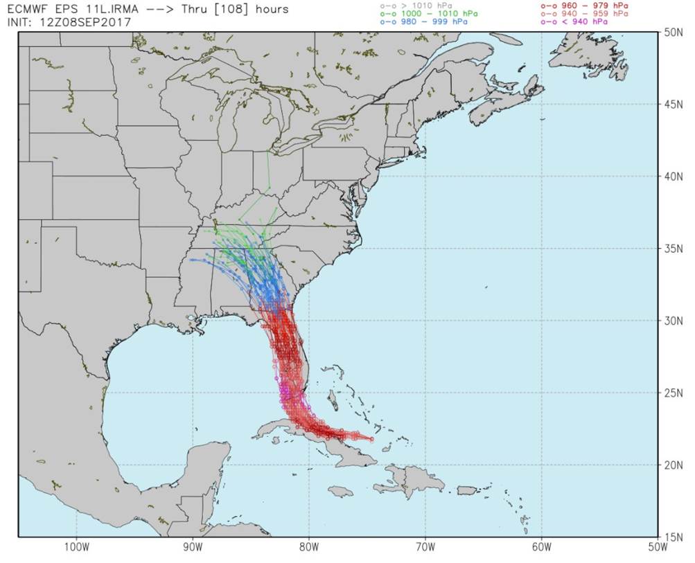
ECMWF initialized 12z Friday September 8th:
ECMWF initialized 12z Friday September 8th:
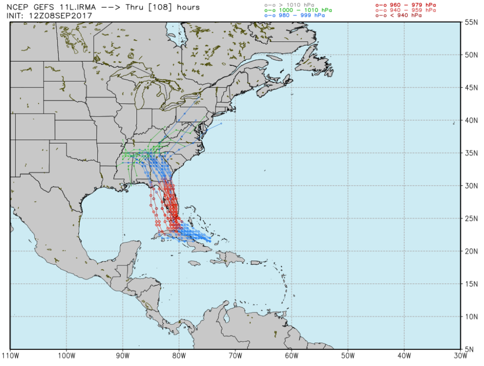
GFS initialized 12z Friday September 8th:
As for the models, ensembles usually have outliers. I don't know and can't guess which models you are specifically referring to; but bear in mind that some of those you will see in tropical forecasts include not only dynamical models but also statistical models, some blended dynamical-statistical models, some simple trajectory models and some climatological.
Always remember the old adage: "All models are wrong; but some are useful."
Stephen.
Reply all
Reply to author
Forward
0 new messages