Stephen Davenport
Here are the forecast T2m anomalies per GFS. Little doubt that there'll be date records in places east of the Rockies across the Ohio and Tennessee Valleys to Appalachia.
Stephen Davenport
A line of relatively weak thunderstorms went through between 1430 and 1500 EST ahead of a cold front approaching from the west on the forward side of a deep upper trough over the Central Plains. There's ~1000J/kg of MLCAPE along and south of a warm front straddling Michigan and lake Erie west-east, with decent vertical shear and steep lapse rates, so that's going to be favourable for severe storm / isolated tornado risks as the second wave develops and comes through Indianapolis 1700-1900 EST. There's a greater threat to the east and northeast of the city but damaging straight line winds and hail are likely on the squall line.
It'll be much colder after the front with a few flurries - looking at highs of just 1-2 C for Saturday, a drop of 21-22 degrees.
Midwest weather is rarely boring. There's virtually four seasons in one system with storms and heavy rain here + severe storm risks, deep snow for the central Plains and the Upper Midwest, freezing rain for the eastern Great Lakes and parts of central-southern Ontario, record or near-record high temperatures ahead of it and below-seasonal cold behind.
I made a few screen grabs at midnight last night as this all started - radar (green-orange rain, blue snow, pink freezing rain / ice pellets just beginning). There was thundersnow, too, in Wisconsin.
Stephen
Indianapolis IN
Richard Dixon
Julian Mayes
John Hall
Stephen Davenport
The following, among others, set all-time February records on Friday 24th: Boston MA (73 F, which was 3 F above the previous record), Allentown, PA (a remarkable 77 F), Binghamton, NY (70 F), Akron OH, Dayton OH, Cincinnati OH and Columbus OH. On Thursday 23rd, Albany NY hit 74 F, its highest temperature for any winter day, Dec-Jan-Feb. Burlington VT beat its February record on Thursday 23rd (hitting 63F) and again on Saturday 25th with 66F.
On Wednesday 22nd Milwaukee (71F), Madison (68F) and Green Bay WI all had record highs for not just February but for any month during meteorological winter. Meanwhile, Ottumwa IA had a high of 79 F - another monthly record.
Although warm south-westerly winds were at root responsible, the lack of snow cover due to previous warm periods during the winter meant that they stayed even warmer than they would ordinarily have been. Only 19% of the lower 48 is currently snow-covered; and aside from New England and near the Canada border, most of that is over the Rockies, Sierra Nevadas and Cascades.
Temperature anomaly Feb 1st-25th:
Snow cover on Feb 22nd:
For interest, Europe temperature anomaly February 1st-25th:
Stephen
Stephen Davenport
On Saturday, February 25, 2017 at 5:49:15 AM UTC-5, Julian Mayes wrote:
Yes, thanks Stephen, a very useful overview as usual (it is nice to see the synoptic context for the specific events - we hear a lot of the individual weather extremes and other events in North America via the media without explanatory context).Cheers Julian
As suspected most of the severe action was to the east and northeast but even more so than I thought. The second band of storms on the cold front did not amount to much over Indianapolis but got severe-warned for the Ohio border and into SW Ontario, and eastwards across Ohio Friday night then into Pennsylvania Saturday. In fact there was a tornado in Pennsylvania:
http://paweatheraction.com/raw-video-a-tornado-on-the-ground-near-scranton-pa
...and another suspected in Maryland (warning - video starts automatically):
http://www.wusa9.com/weather/tornado-warning-for-parts-of-maryland/414664663
The temperature here in Indy got to just 0 deg C Saturday, 23 degrees lower than Friday, with on-and-off flurries leaving just a trace covering.
Stephen
Indianapolis IN
Stephen Davenport
On Friday, February 24, 2017 at 4:49:28 PM UTC-5, Richard Dixon wrote:
Cheers Stephen. Very interesting. Never a dull winter in America, it would seem..
Stephen Davenport
https://www.youtube.com/watch?v=XT7GAtFApPI
Stephen.
John Hall
Trevor Harley
John Hall
I am looking to a bit of time back home in San Francisco from this weekend, where it has been stormy and wet. But things look to be turning a bit more settled - just a bit more mild than Dundee.
Stephen Davenport
On Tuesday, February 28, 2017 at 4:10:04 AM UTC-5, Trevor Harley wrote:
I am looking to a bit of time back home in San Francisco from this weekend, where it has been stormy and wet. But things look to be turning a bit more settled - just a bit more mild than Dundee.
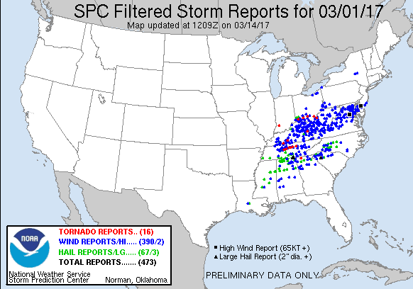
Meanwhile there'll be severe storms and tornadoes developing later today from the Ozarks to the Ohio Valley; I'll make another post about that.
Stephen Davenport
Trevor Harley
Stephen Davenport

| Public Severe Weather Outlook (PWO) | |
 | |
   ZCZC SPCPWOSPC ALL
   WOUS40 KWNS 281650
   ARZ000-ILZ000-INZ000-KYZ000-MOZ000-OHZ000-TNZ000-010200-

   PUBLIC SEVERE WEATHER OUTLOOK
   NWS STORM PREDICTION CENTER NORMAN OK
   1050 AM CST TUE FEB 28 2017

   ...Severe thunderstorms expected over parts of the Ozarks region to
   the Ohio Valley late this afternoon into tonight...

   * LOCATIONS...
     Indiana
     Western and northern Kentucky
     Southern and eastern Missouri
     Illinois
     Northern Arkansas
     Northwest Tennessee
     Far western Ohio

   * HAZARDS...
     Several tornadoes, a few intense
     Widespread large hail, some baseball size
     Scattered damaging winds

   * SUMMARY...
     Severe thunderstorms are expected to develop from portions of
     the lower Mississippi Valley to the Ohio Valley through tonight.
     Strong tornadoes will be possible, especially across portions of
     the lower and middle Ohio Valley. Otherwise, large hail and
     damaging winds are expected.

   Preparedness actions...

   Review your severe weather safety procedures for the possibility
   of dangerous weather today. Stay tuned to NOAA Weather Radio,
   weather.gov, or other media for watches and warnings. A tornado
   watch means that conditions are favorable for tornadoes to form
   during the next several hours. If a tornado warning is issued for
   your area, move to a place of safety, ideally in a basement or
interior room on the lowest floor of a sturdy building.StephenIndianapolis IN | |
Richard Dixon
Richard
Stephen Davenport
Jack Frost
https://www.youtube.com/watch?v=Kv-AiFj_nbw
Liam
Chicago
Stephen Davenport
Stephen
Indianapolis IN
Stephen Davenport
Stephen
Richard Dixon
Trevor Harley
Jack Frost
Stephen Davenport


Stephen Davenport


Stephen Davenport
On Wednesday, March 1, 2017 at 5:52:06 PM UTC-5, Richard Dixon wrote:
That large hail pic is interesting - I realise large hail is agglomeration of smaller hailstones, but this seems like an agglomeration of moderate-sized conical-shaped hailstones.Richard
Richard Dixon
Indeed. There are often arguments about whether this sort of thing is one hailstone or a bit of a cheat with many stuck together. Ultimately it makes little difference if your roof, car or head is underneath it!Stephen.


