A misplaced warning?

140 views
Skip to first unread message

xmetman

unread,
Aug 27, 2019, 5:14:37 AM8/27/19
to Weather and Climate

There have already been a few SFERICs in the Channel Islands that give me the impression that the warning area for thunderstorms today could be doing with being widened a bit.


2019-08-27_101010.jpg


xmetman

unread,
Aug 27, 2019, 10:53:13 AM8/27/19
to weathera...@googlegroups.com

2019-08-27_154040.jpg


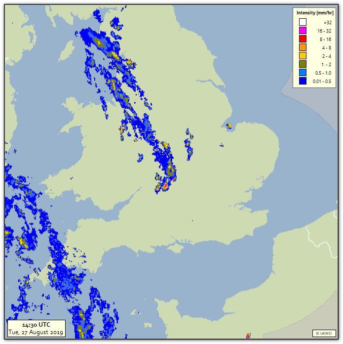
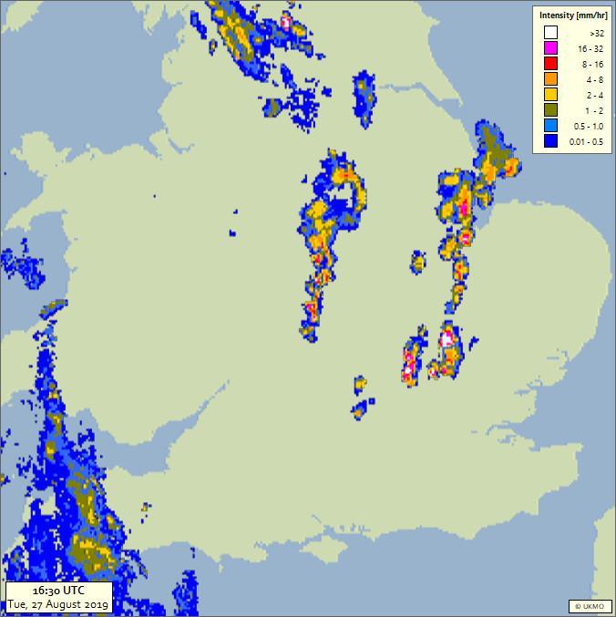
It looks like the rain over the Midlands is falling from unstable medium/high level cloud with not much reaching the ground. One flash west of London in last hour but very lively over rest of Europe - thank you Susan Powell.


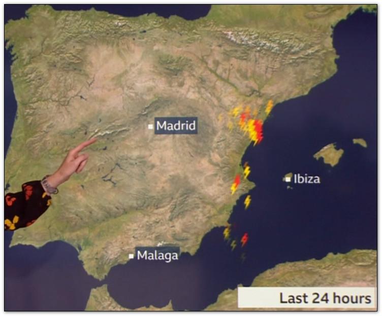
I wonder why she couldn't show images from the latest Met Office SFERICs at 3.30 PM?


2019-08-27_154934.jpg


Never mind Blitzortung to the rescue!


2019-08-27_154448.jpg


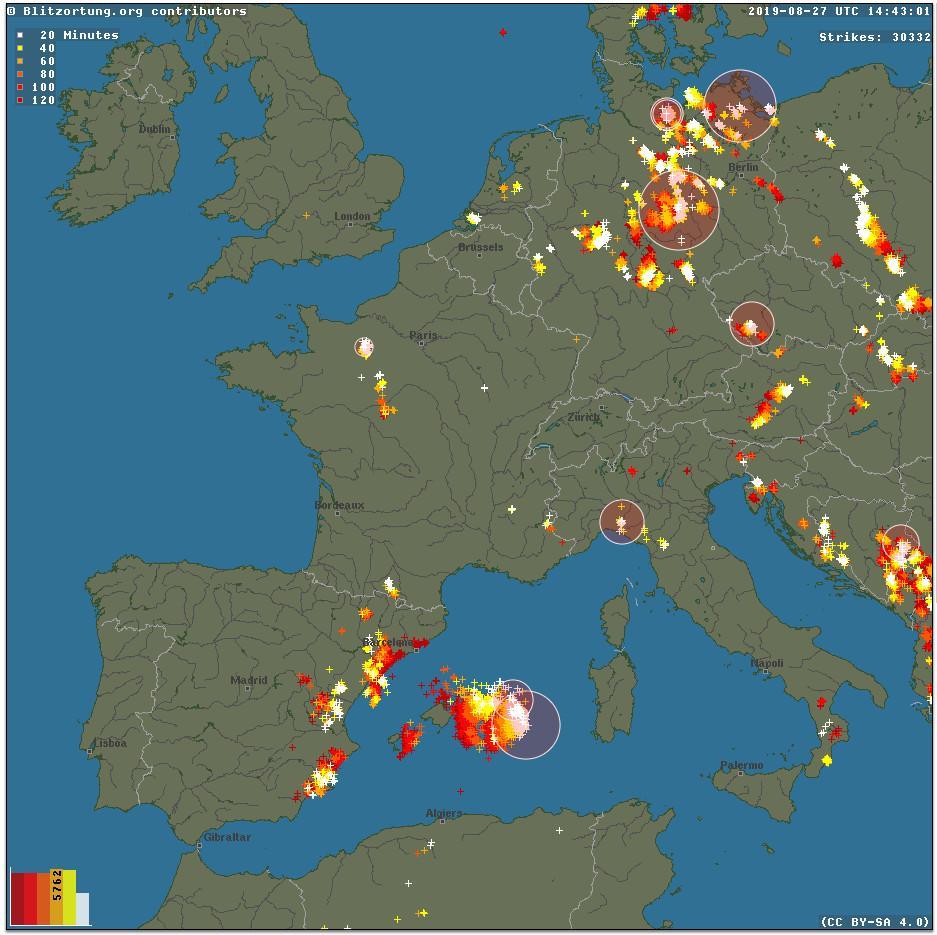
Obviously after BREXIT this German data will be unavailable.


xmetman

unread,
Aug 27, 2019, 11:45:12 AM8/27/19
to Weather and Climate
Thunderstorm in last hour reported at Brize Norton at 15 UTC 

Julian Mayes

unread,
Aug 27, 2019, 11:58:19 AM8/27/19
to Weather and Climate
From the radar it looks like we have another Epping storm, George.  Towering cu started developing over west London around 2-3pm and now the sky to my NE looks as shown below - I'm the opposite side to Epping if geographical clarification is needed!. I fear that the activity has hopped over this area, at least for the time being. 


FullSizeRender (800x480).jpg

First attempt to upload an image. I'll get the size right eventually. 

Julian  

xmetman

unread,
Aug 27, 2019, 12:41:19 PM8/27/19
to weathera...@googlegroups.com
You have to click on the image and select from the menu that pops up at the bottom of the image.
As far I know the images that you submit to the forum come out of your allocated 5 GB allowance but I'm not entirely sure...

2019-08-27_173855.jpg


Thos tops are a fair way away.

2019-08-27_174258.jpg


Julian Mayes

unread,
Aug 27, 2019, 2:38:35 PM8/27/19
to Weather and Climate
Xmetman wrote: Those tops are a fair way away.

When I took the photo they were a bit further south, hence the reference to Epping. They'd moved a fair bit during the time I was fiddling around with the photo! 

A very welcome southerly breeze arrived here at exactly 17Z. Either a sea breeze or maybe an inflow behind the storms?  Maybe a bit of both?   People around here (I mean in this area, not the forum!) would be surprised at how often a sea breeze reaches south London / lwr Thames valley. 


Len

unread,
Aug 27, 2019, 3:02:08 PM8/27/19
to Weather and Climate
Yes, I remember the sea breeze arriving in London at approx 6 pm after a hot day when I was living there in the seventies.

Max 22C here today
0.6 mm rain. The heavyish rain last night missed here.

I see Linconshire is copping it again atm. A good call from UKMO.

Len
Wembury, SW Devon

xmetman

unread,
Aug 27, 2019, 3:09:17 PM8/27/19
to Weather and Climate
Yes Len - I was a bit skeptical about the area not covering southern England - but apart from the thunderstorm at Brize they got it on the nose.

Freddie

unread,
Aug 27, 2019, 3:14:13 PM8/27/19
to Weather and Climate
They were probably aware of the potential for storms further south, but saw that potential as too small to extend the warning in that direction. They will only issue if reasonably confident - or if the impact would be massive.

--
Freddie
Dorrington
Shropshire

xmetman

unread,
Aug 27, 2019, 3:49:32 PM8/27/19
to Weather and Climate
It is of course impossible to say without seeing this morning's run of their mesoscale model output, and because they secrete that away for the benefit of their customers and not the public you can only guess that the model and their assessment of it was right.

Me an you are like glass half full - glass half empty. You believe it was the accuracy of their NWP, I believe they were a wee bit lucky. Until they make it public I will always remain slightly skeptical of it.

Either way it means very little in reality - unless of course your thatched cottage across the road from Brize Norton was struck by lightning and burnt to the ground 🤪

Freddie

unread,
Aug 27, 2019, 4:08:33 PM8/27/19
to Weather and Climate
On Tuesday, 27 August 2019 20:49:32 UTC+1, xmetman wrote:
It is of course impossible to say without seeing this morning's run of their mesoscale model output, and because they secrete that away for the benefit of their customers and not the public you can only guess that the model and their assessment of it was right.
True, but they would assess more than their own model, then quantify risk based on that comparison plus what is actually happening in the atmosphere around the time of issue of the warning - i.e. compare, say, the T+6 fields of the model with what the radar, satellite imagery, upper air reports (balloons, aircraft, etc.) and surface data are showing - before making a decision.  They are a clever bunch  - not just NWP "dot followers".


Me an you are like glass half full - glass half empty. You believe it was the accuracy of their NWP, I believe they were a wee bit lucky. Until they make it public I will always remain slightly skeptical of it.
I think it's the other way around - me glass half full :-)

I don't think luck came into it - just careful consideration, both of probability and impact.  If it had all gone wrong I don't think they would put it down to bad luck - there would be a proper post-event analysis, with some sort of "lessons learned" guidance for future similar events.  I guess unless you're actually in the room with them, we will never know!


Either way it means very little in reality - unless of course your thatched cottage across the road from Brize Norton was struck by lightning and burnt to the ground 🤪
Absolutely - and if the risk of that is too small then they won't warn.  If they did warn every time there was the smallest likelihood then they would get accused of crying wolf :-)

--
Freddie
Dorrington
Shropshire
115m AMSL
http://www.hosiene.co.uk/weather/
Stats for the month so far: https://www.hosiene.co.uk/weather/statistics/latest.xlsx
Message has been deleted

Smartie

unread,
Aug 27, 2019, 6:41:41 PM8/27/19
to Weather and Climate
Global, UKV, MOGREPS-G and -UK data are available with 24-hr latency here--

Len

unread,
Aug 28, 2019, 5:28:45 AM8/28/19
to Weather and Climate
Is n't Github are rather comical name or just to put people off?
;-)

Len
Wembury

xmetman

unread,
Aug 28, 2019, 5:39:37 AM8/28/19
to Weather and Climate
Yes Smartie, I knew about this new service that I think supersedes the DataPoint API. 
It's far too involved and complicated for me I'm afraid, and out of date NWP data is rather like three hour old satellite or radar imagery, of little use except for autopsy purposes!

xmetman

unread,
Aug 28, 2019, 5:41:15 PM8/28/19
to Weather and Climate
Whilst having a bath - I've been giving some thought to warnings and impacts and why the Met Office need to guess at the impact of any given warning they issue?

Surely this should be the responsibility of the individual or organisation to heed the warning and apply it to their situation. For example they may be forecasting 25 cm of drifting snow above 300 m in Scotland. The impact is going to be high for hill farmers with sheep, but then they would know the impact would be severe - anyone with half a brain would know this as well. Infact because the impact would affect a small subset of the population it would barely merit a yellow warning anyway under current thinking.

Why not ditch the "impact" colours and just issue warnings with colours for "likelihood" as in the good old days of yore? Do we need to tell people to watch out for the obvious - yes there's going to be a frost tonight and that they may well fall on their arses in the morning if they don't take care - and mind that thick fog because if you drive too fast you may well have an accident.

It seems to me that warnings and the micro management of them - since the demise of their monopoly - has become the whole raison detre for UKMO forecasters, and they have - like they've done with their analysis charts - turned it into an art form.

Len

unread,
Aug 28, 2019, 6:38:41 PM8/28/19
to Weather and Climate
Here here Bruce.
Nanny state and all that.

The mellow yellow is used far too often.

Len
Wembury


Smartie

unread,
Aug 29, 2019, 4:37:21 AM8/29/19
to Weather and Climate
Torvalds does have a sense of humour. It's a place for  the young gits-in-waiting to polish the shiny technological future and not for old-gits like you or I.
It's actually a very good way of managing moderate to highly complex code projects...which is why it's so successful.

Smartie

unread,
Aug 29, 2019, 4:58:38 AM8/29/19
to Weather and Climate
The warnings system seems to have worked very well in this case. The elevated convection in the SW (poorly forecast or not) appears not to have bneen warned as it was below the impacts threshold.
Deep convection, more surface based,  later in the day was warned. There are  scattered reports of large hail (30mm+), heavy rain and marginally strong downdraught winds from across eastern and northern England.
Network radar shows these occurred with storms exhibiting supercell-like behaviour including splitting, deviant right motion and hail cores. NB the warning area does not cover western central south areas where these showers were first born but eastern  and northern areas into which the sjhowers moved. By 16 UTC this is colocate with a thermal low across eastern Englanf with backing surface winds and convergence zone boundaries, known ingredients for severe convective weather, see eg.
A damaging microburst and tornado near York on 3 August 2011
August 2012Weather 67(8):218-223. DOI: 10.1002/wea.1925. D. J. Smart, Matthew ClarkLouise HillTim Prosser
Model profiles indicate high instability (CAPE>1000J/Kg, moderate deep layer shear and strong low-level shear (VGP 0.2) suggesting a tornado risk and column precipitable water >4cm suggesting a localised flooding risk (although storms were on the move.)

wrf.d01.sdg_leeds.00540.png

wrf.d02.divd02.00600.png


Freddie

unread,
Aug 29, 2019, 5:46:55 AM8/29/19
to Weather and Climate
On Wednesday, 28 August 2019 22:41:15 UTC+1, xmetman wrote:
Whilst having a bath - I've been giving some thought to warnings and impacts and why the Met Office need to guess at the impact of any given warning they issue
Where does guessing come into it? Hazards of various weather types are known.  If those hazards are likely to affect a significant number of people then a warning will be issued.  To use an example - the thunderstorms on Tuesday.  The warning area was chosen because that was where severe surface-based convection was anticipated to occur.  True the potential for thunderstorms existed south and west of this - but the impact was assessed to be lower (mid-level convection with not as much precipitation reaching the ground; not as much energy available for convection due to the time of day; lack of hail and strong gusty winds) as was the likelihood (much lower - but not zero - probability of a storm occurring).

Surely this should be the responsibility of the individual or organisation to heed the warning and apply it to their situation. For example they may be forecasting 25 cm of drifting snow above 300 m in Scotland. The impact is going to be high for hill farmers with sheep, but then they would know the impact would be severe - anyone with half a brain would know this as well. Infact because the impact would affect a small subset of the population it would barely merit a yellow warning anyway under current thinking.

We all have a responsibility for our own safety, that has never been in doubt.  The warnings are advice to help inform your decision.  It used to be that warnings were issued whenever severe weather was forecast.  The problem with that was that the impact of the warnings becomes reduced (so-called "crying wolf"), not to mention the requirement for persistent warnings for hill fog and strong winds for mountains, as well as snow for 2/3 of the year.  That's why the system was changed to include impact and likelihood.

Why not ditch the "impact" colours and just issue warnings with colours for "likelihood" as in the good old days of yore? Do we need to tell people to watch out for the obvious - yes there's going to be a frost tonight and that they may well fall on their arses in the morning if they don't take care - and mind that thick fog because if you drive too fast you may well have an accident.

The forecasters use a matrix system that assesses both likelihood and impact - so both those scenarios are covered.

It seems to me that warnings and the micro management of them - since the demise of their monopoly - has become the whole raison detre for UKMO forecasters, and they have - like they've done with their analysis charts - turned it into an art form.

There hasn't been a change to the warnings system since the BBC contrast passed to MeteoGroup (I think that's what you mean by "demise of their monopoly"?).  The warnings will be being pushed harded through more channels, as the amount of "direct publication" would have been reduced.

xmetman

unread,
Aug 29, 2019, 6:39:17 AM8/29/19
to Weather and Climate
What I was trying to get across is that the Met Office are expert in predicting things in meteorological units:-

  • The maximum temperature will be 38°C
  • There will be 25 cm of drifting snow.
  • There will be a moderate frost tonight minimum temperatures -4°C
  • The dense fog will reduce visibility to less than 50 metres.
  • The heavy rain tomorrow will produce totals of 50 mm or more
But the impact of these events can only be guessed at and the Met Office aren't always best placed to add any further meaningful advice to quantifying any impact, other than slow down, take care, stay indoors which of course they do.

Heavy rain warnings area a perfect example because I would have thought that UKMO NWP data is provided to the EA/SEPA to feed into their flood models - and its for them to quantify the impact that rain will have, which they do.

Heatwave and air quality warnings are another example that need input from outside experts and strangely is not a part of the NSWWS.

What does seem odd to me is that this system quantifies impacts by the number of people directly affected:-

A pensioner this winter who slips on any icy pavement breaks his hip, catches pneumonia and dies 3 weeks later in hospital that's a yellow, but 100,000 commuters who can't get into London because of the wrong kind of snow and get a day of work that's an amber or red.

I don't know why I get so worked up about warnings because I reckon the number of people who hear and heed them is small.

Graham Easterling

unread,
Aug 29, 2019, 7:32:45 AM8/29/19
to Weather and Climate
We all have a responsibility for our own safety, that has never been in doubt.  The warnings are advice to help inform your decision. 

I think that sums it up nicely.

A warning of a big sea may attract people in large numbers to watch it (certainly works for me!) but at least they've been warned.  A gale warning, combined with a swell prediction & a glance at the tide tables, and you know pretty much what to expect.

Press warnings amuse me sometimes though. 'Stay away from the sea' doesn't really work if your house is next to it! At least it gives people time to get the sandbags out. Main line into Penzance under adverse conditions (why does only Dawlish ever get a mention?)

penzance-train-tracks-storm.jpg


The last 6 months have been spent improving the sea defences along the line into Penzance, it was in a really bad way.

Graham
Penzance


Paul from Dawlish

unread,
Aug 29, 2019, 8:33:44 AM8/29/19
to Weather and Climate
Dawlish is clearly very special Graham. *>))

Graham Easterling

unread,
Aug 29, 2019, 8:53:13 AM8/29/19
to Weather and Climate
Yes, to be fair the line being shut at Dawlish clearly has bigger implications than it being shut just outside of Penzance. (. . and it's too far for the reporters to travel!)

Graham

Freddie

unread,
Aug 29, 2019, 11:26:12 AM8/29/19
to Weather and Climate
I did write a detailed reply to this but it failed to send and now I can't find it.  The crux of the reply was that (a) the Met Office DO get their advice on impacts from external bodies such as the EA and SEPA, and they (in the case of heavy rain warnings) wouldn't warn if the impacts advice suggested there was no need to warn; (b) Heat health and cold weather warnings are department-to-department warnings - Met Office warns of hot/cold weather, NHS assesses the impacts and acts on their own advice; (c) I agree that warnings aren't necessarily heeded, but they are definitely "consumed" by a lot of people.
Reply all
Reply to author
Forward
0 new messages