Skip to first unread message

xmetman
Jun 14, 2019, 3:31:55 PM6/14/19
to Weather and Climate
I notice these two tweets today, one from Meteogroup (aka BBC weather) and their chums down at the Met Office in Exeter.
It took the Met Office a good while (8 hours) to try and replicate what Meteogroup had done, but they got there in the end, even if the animation is a wee bit rough around the edges.
Of the two animations, I find the Meteogroup one looks the slickest even if the colour scheme of all blues is less helpful.

xmetman
Jun 14, 2019, 3:34:32 PM6/14/19
to Weather and Climate
I forgot the video links to twitter...
MeteoGroup - https://twitter.com/i/status/1139435798409797633
Met Office - https://twitter.com/i/status/1139550808574496768

Graham Easterling
Jun 15, 2019, 5:28:36 AM6/15/19
to Weather and Climate
Talking of rainfall radar, just why is the MetO radar so painful to watch?
I haven't used it for months, so I just glanced to see if it has improved, but no. . and as for the layout of the 5 day forecasts, bad enough on a PC, buthas anyone at the MetO tried using it on an iPad!
I'm not saying the forecasts elsewhere are better, but they could learn a lot by the layouts elsewhere, say the GFS based ones on XCWeather https://www.xcweather.co.uk/forecast/Wadebridge
Graham
Penzance
xmetman
Jun 15, 2019, 8:07:24 AM6/15/19
to Weather and Climate
I don't know about that Graham but I think the latest weather radar, like visible satellite imagery isn't used enough in TV weather forecasts.
<rant>We (as taxpayers) pay the Met Office to maintain (and recently revamp) the radar network across the UK (excluding Shetland) as well as contributing millions to EUMETSAT to maintain a number of weather satellites. We rarely see the output from either service on our national weather forecasts. The last time I looked at the Eumetsat web site you could access their hi-resolution visible satellite imagery in some tedious kind of way, but not the real time stuff only for T-24.</rant>
I suspect the reason why they prefer not to show the latest radar and visible satellite imagery in TV forecasts though and would prefer to pass off the latest forecast NWP frame as real time, rather than using the latest radar overlaid on top of the latest visible satellite image, is because of the mismatch between the NWP forecast and reality. More often or not even at T+3 the two would be out of step, and is highlighted even more when they run an animation, so the simple answer is don't even bother doing it, because we all know that the model is always right don't we?
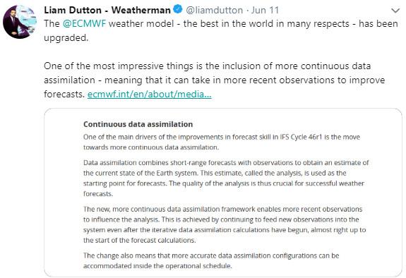
I notice that in one of Liam Dutton's tweets this week that the ECMWF are implementing "Continuous data assimilation" into their weather models. This could perhaps smooth out any mismatch between reality and the early frames of the latest model.
Reply all
Reply to author
Forward
0 new messages