Skip to first unread message
Martin Rowley [West Moors/East Dorset]
Mar 6, 2017, 4:02:57 AM3/6/17
to Weather and Climate
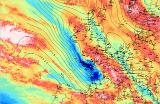
... Vicious little animal running quickly across NW France - gusts on this chart to 90 kn. Not necessary to have very low pressure either - just a very tight circulation associated with a powerful jet.
Martin.

Martin.
Jack Harrison
Mar 6, 2017, 5:38:33 AM3/6/17
to Weather and Climate
Metars Quimper
http://weather.uwyo.edu/cgi-bin/wyowx.fcgi?TYPE=metar&DATE=current&HOUR=current&UNITS=M&STATION=lfrq
Note the rapidity of the onset of the gale after 0400 hours.
Jack
http://weather.uwyo.edu/cgi-bin/wyowx.fcgi?TYPE=metar&DATE=current&HOUR=current&UNITS=M&STATION=lfrq
Note the rapidity of the onset of the gale after 0400 hours.
Jack
Smartie
Mar 6, 2017, 6:42:34 AM3/6/17
to Weather and Climate
There appear to be unofficial reports of gusts for Quessant -190 KPH (~53m/s) and Camaret (193 KPH) on French social media.
Weatherobs gives a peak gust of 176 KPH for Quessant Is. on a mean wind of 117 KPH from the WNW at around 06Z. Anticipating queries by Richard-
A high resolution WRF run suggests any discrete SJ reaching the surface may have been weak in this case and the CCB jet was dominant.
Here are WV, metars and ship/buoy obs for 06Z with GFS T+12 MSLP. There are two warm areas in the satellite imagery implying descent and warming from aloft, the leading one could be the signature of a SJ. The trailing (western) area is a chevron-like feature ahead of the main cloud head filament, the wind direction of the extreme gusts implies the CCB jet is responsible but experience from analysis previous storms suggests there is (another) SJ in close proximity aloft.
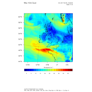
Max gusts from a 5km WRF run initialised with the 18Z GFS 5 March.
Jack Harrison
Mar 6, 2017, 9:59:30 AM3/6/17
to Weather and Climate
It seems then it was forecast fairly accurately at 1800 on 5th March. Had it been forecast before then?
Any news of casualties? I can find no details on British media..
Jack
Any news of casualties? I can find no details on British media..
Jack
Smartie
Mar 6, 2017, 2:52:10 PM3/6/17
to Weather and Climate
See eg
1 fatality (outside main warning area), at least 3 severely injured.
190,000 without power.
Colin Youngs
Mar 6, 2017, 5:20:45 PM3/6/17
to Weather and Climate
OGIMET table showing extremely strong gusts http://tinyurl.com/zyvhewu
Le Monde online http://tinyurl.com/h3aay24
600,000 households suffered power cuts - the highest number in a single storm since 1999.
2 deaths: a lorry driver whose vehicle was hit by a falling tree in the Alpes-de-Haute-Provence (in SE France) and a 43-year-old man when a tree fell on his car at Coulounieix-Chamiers in the Dordogne.
3 teenagers badly hurt by a falling tree at a school at Carhaix in Brittany; 2 other people hurt by falling trees at Pont-Scorff and Pontivy, also in Brittany.
Colin Youngs
Brussels
Jack Harrison
Mar 7, 2017, 12:08:45 AM3/7/17
to Weather and Climate
Still not sure how far in advance the first warning of severe weather had been made.
Jack
Jack
Smartie
Mar 7, 2017, 3:50:00 AM3/7/17
to Weather and Climate
See this page here-
the French local area models init 12Z Sunday seem to have done a good job. The 18Z GFS run has the right idea but the resulting gust swath in the GFS-WRF is a little too far north.
Runs of the ECMWF ensemble init on the 4th I have seen indicate a risk for southern central France but don't focus in on NW France until the 00Z and 12Z runs on the 5th.
A post-mortem from the ECMWF will go up here-
David Mitchell
Mar 7, 2017, 5:49:43 PM3/7/17
to Weather and Climate
Well the wind got to us as well, though not to the same extent as further North. Our power returned this evening after 29 hours without it. In this area of Limousin 72,000 homes were without power yesterday.
Loads of trees down locally, one in our garden and I had to divert from a back road home this afternoon because a large tree was blocking the road that I'd only driven down an hour before and the wind was calm!
In the seven days to midnight last night we've had 150mm rain/snow and the rivers have expanded somewhat, with some very impressive rapids in places.
All quite exciting weather wise, but nothing really exceptional here and no local reports of injuries. Got a great deal on a chain saw in a closing down sale today though.
DM. 740m. La Moratille. Correze. France.
Reply all
Reply to author
Forward
0 new messages


