Skip to first unread message

Julian Mayes
Jan 10, 2021, 6:11:24 PM1/10/21
to Weather and Climate
I stumbled across this programme by accident earlier this evening....a history of severe weather in the UK.
I was actually quite impressed at how informative it was (it was BBC Four!) running from the Bristol Channel floods of 1606 through the well known disasters since then. It is available for nearly a month on the i-player and is worth watching. BUT there was one howler of an error and one odd explanation.
The odd explanation concerned the frost hollow status of Braemar - it would have been nice to have referred to and shown the confluence of the two valleys there and maybe to mention the altitude.
The howler was to attribute the Brogdale hi temp record in 2003 to the urban warmth of London. I am not making this up! It was also stated that this was the highest UK temp on record which of course is no longer true, but I do not know how old the programme was. The presenter, Lucie Green, was filmed at Brogdale in the met enclosure - now if only the camera had turned around we'd have seen the conifer hedge that some of us think sheltered the site. Turn to the pages of Weather for mid 2004 to get the details of the debate - that was certainly an interesting issue to put together. .
Question is - who advised the presenter? No met consultant was listed in the closing credits so maybe that's the answer. It's only the weather,we don't need accuracy! (I hope it wasn't someone on this forum).
Julian

Len
Jan 12, 2021, 6:23:25 PM1/12/21
to Weather and Climate
I have just watched the programme.
The bit on Brogdale was silly I agree.
Good to see Kevin Horsburgh at the beginning of the programme talking about storm surges.
He's one of my ex -students.
They also talked about the low temperatures at Braemar.
Surely temperatures have not always been taken in the funny looking garden house on the right.
Len
Julian Mayes
Jan 13, 2021, 8:39:43 AM1/13/21
to Weather and Climate
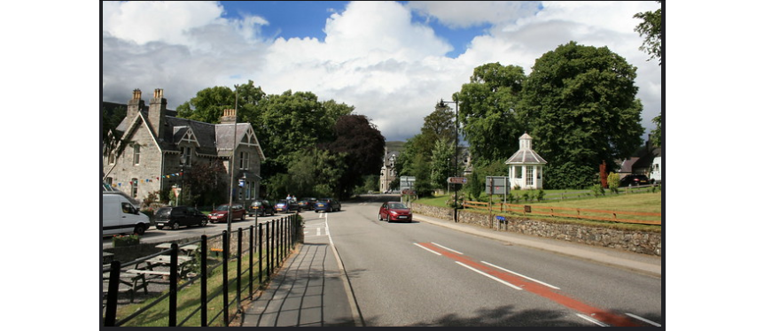
I agree that it seems hard to believe that the 'sun-house' was in use within recent memory. Since automation, the site is here, to the north of the village - down by the river. A much colder frost-hollow. How much lower would the historic -27.2C temperatures be here? You can see that the centre of the village is rather higher up. The view is southwards, you get a sense of the valley joining from the west as well as the valley from the south - typical frost hollow confluence.
Julian

Streetview.
Julian Mayes
Jan 13, 2021, 9:44:27 AM1/13/21
to Weather and Climate
I have just been told the (fairly obvious) fact that the screen and other instruments were sited on the lawn outside the summer-house. So, what was the latter for? Was it where the observer wrote up the ob in comfort? :) I did see vents in the top of the roof, in the cupola thing, which made me think that it has been designed like a huge screen.

Ken Cook
Jan 13, 2021, 11:35:38 AM1/13/21
to Weather and Climate
Hi, Julian,
Afaik the original readings were taken within the summer house (perhaps the 1895 low was recorded there?), there was then an official MetO standard enclosure on the lawn outside which was then re-sited to its current position. The MetO site was still operational in the village when I was there in the 1970's and I think it was still there when I went in the 80's, then moved outside Braemar as Braemar2 an AWS which I saw in the late 90's at a much lower site at the confluence.
Personally, I think it is no longer really representative of Braemar, as Copley Lead Mill is not really representative of Copley Village - but at least it is within the Copley Village boundary. The MetO only want the village readings as it is neither a hilltop nor valley site which, they say, they tend to avoid as they are not representative. However, Braemar2 has been placed in a notorious frost hollow as have other MetO sites - hey ho.
Ken
Copley

Graham Easterling
Jan 13, 2021, 12:34:40 PM1/13/21
to Weather and Climate
Talking of things not representative, excluding Camborne, the sites in central/west Cornwall are Culdrose, St Mawgan (not Newquay as it is often referred to) and Cardinham, all of which are airfields. In fact there are no sites at low level along the 300 miles of coast, where most people in Cornwall live, apart from Bude which is 80 miles from Lands End.
Even the Scilly reports are from an extremely exposed hill top. It makes landing interesting in a small aircraft when there's a gale going vertically up the cliff & swirling around the airport complex. I speak from experience, I used to work for Skybus (not as a pilot!)
Graham
Penzance - Mild & rather mizzly. The shine occasionally shining through the mizzle to give a mist bow.
Reply all
Reply to author
Forward
0 new messages