Interesting line of at least four newly developed CB's

99 views
Skip to first unread message

xmetman

unread,
Jul 30, 2019, 8:37:46 AM7/30/19
to Weather and Climate

2019-07-30_133508.jpg


xmetman

unread,
Jul 30, 2019, 10:28:22 AM7/30/19
to weathera...@googlegroups.com
These cells are certainly proving to be very active at the moment over the Lake District with a new batch following on behind...

2019-07-30_152626.jpg


xmetman

unread,
Jul 30, 2019, 2:52:20 PM7/30/19
to weathera...@googlegroups.com

2019-07-30_194740.jpg

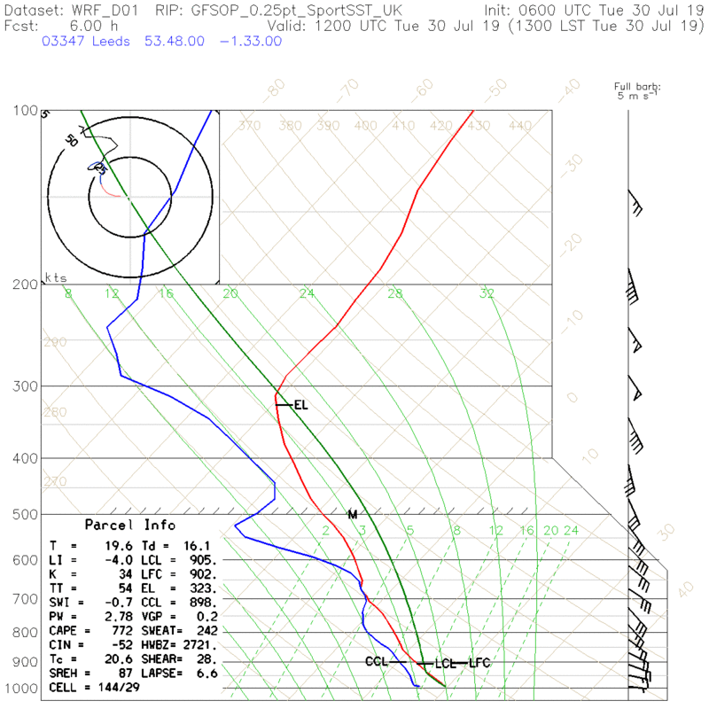
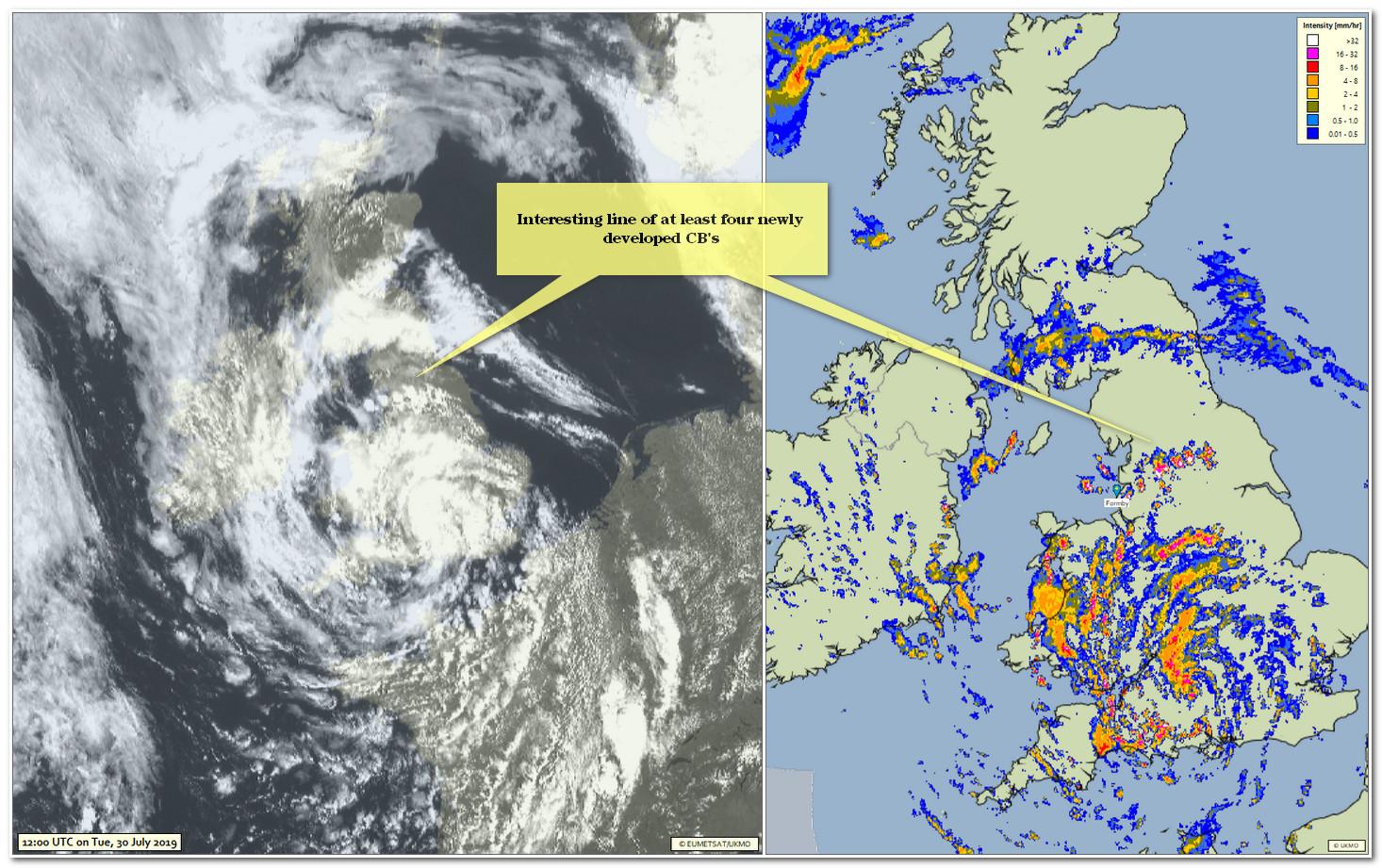
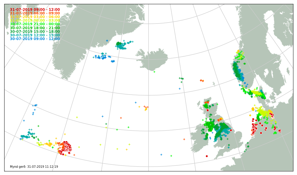
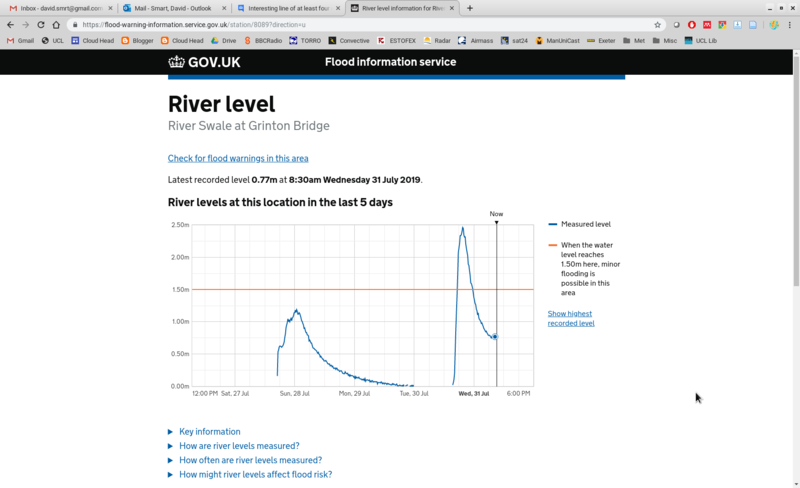
I followed these storms from mid afternoon when I first noticed a line of CB's strung out across northern England.

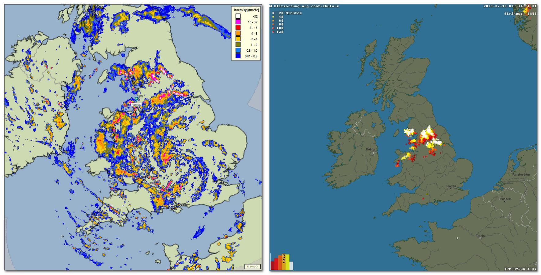
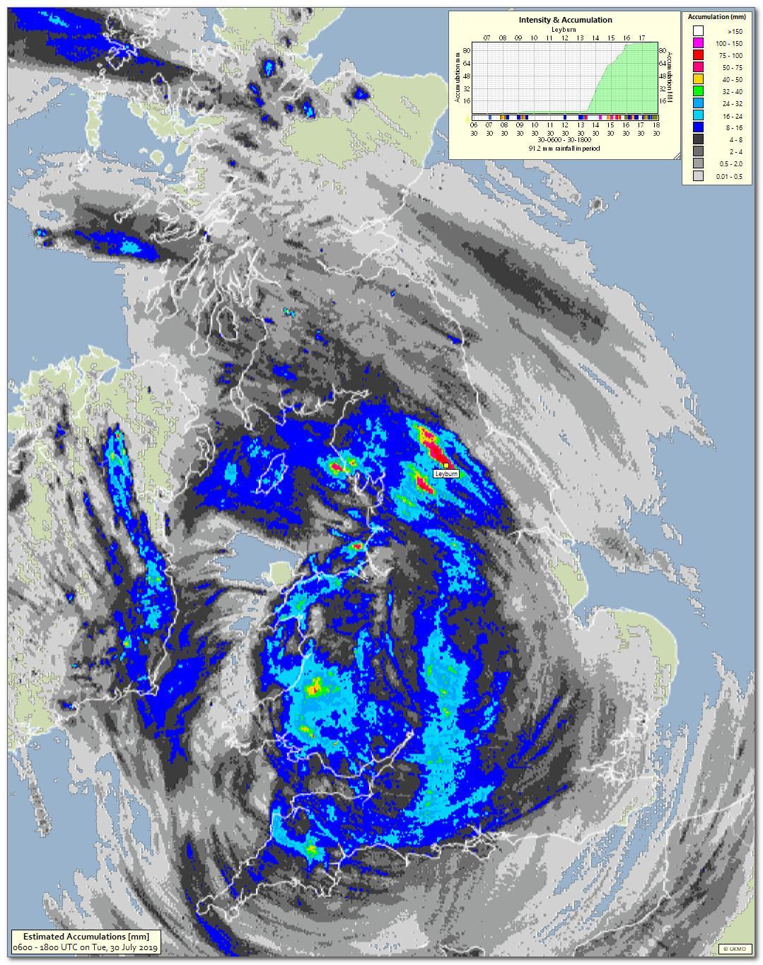
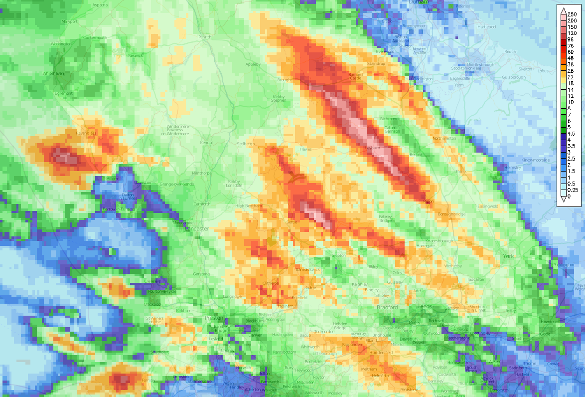
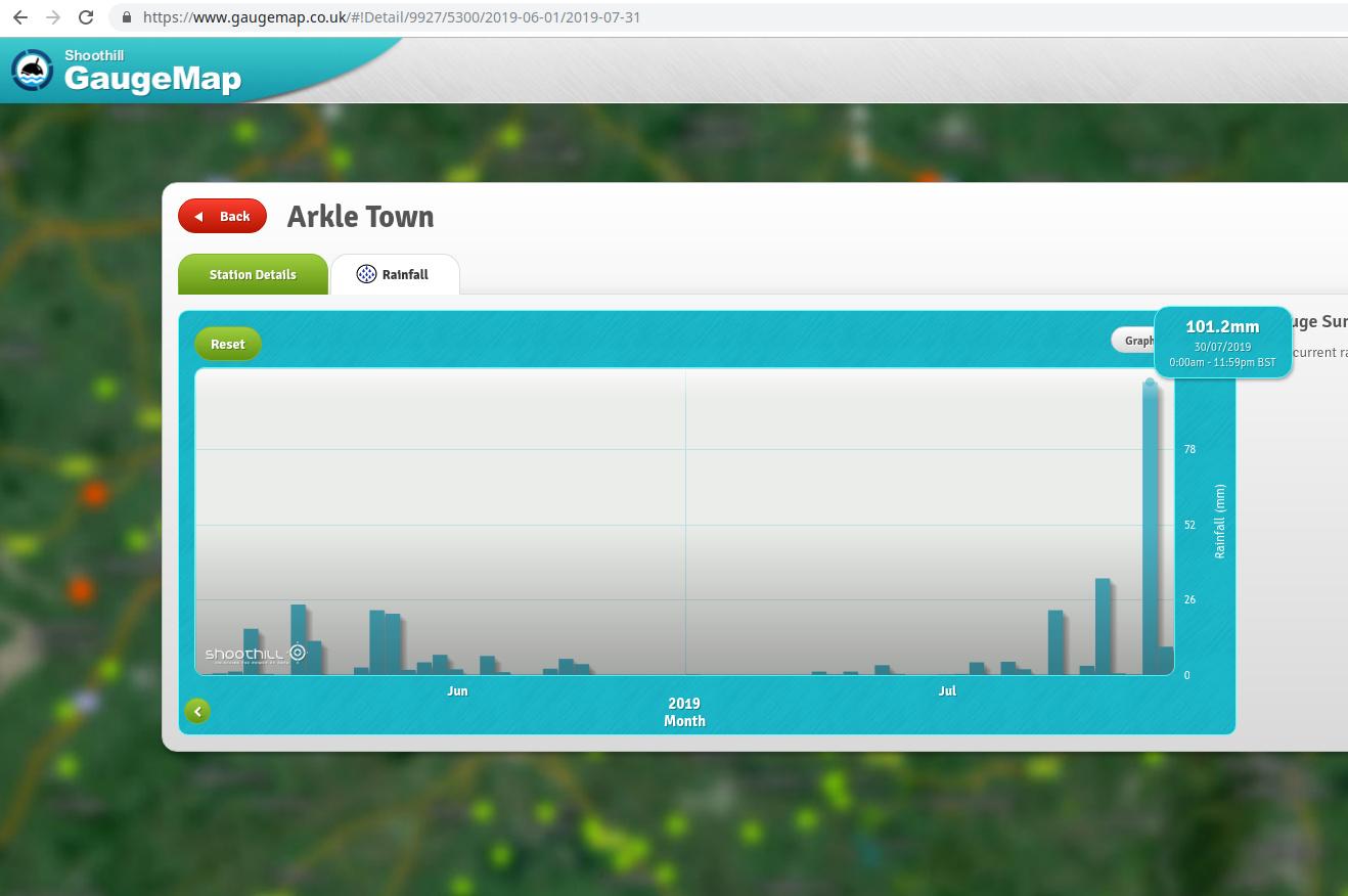
When I ran the analysis of rainfall estimates I thought they might be at least a magnitude of x2 too large.

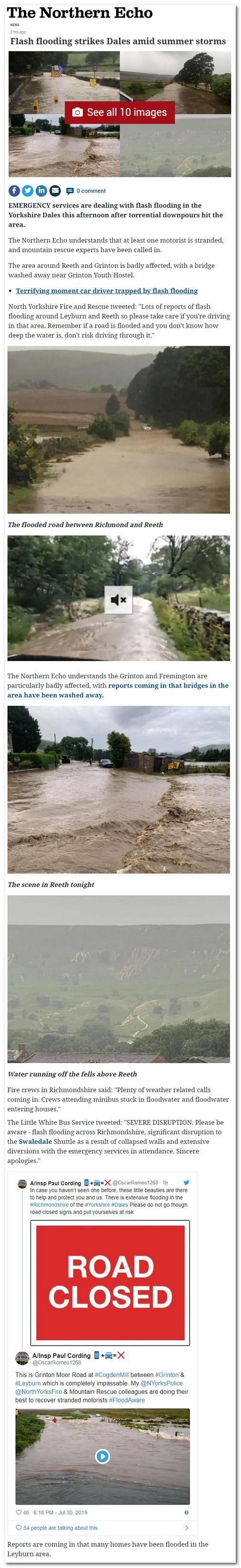
I did a quick Google search and found the news of the flooding in the Leyburn area and realised they might be not too far off the mark.

By the way Valley did get away with a dry day!


2019-07-30_194248.jpg

xmetman

unread,
Jul 30, 2019, 4:40:47 PM7/30/19
to Weather and Climate
Persistent slow moving thunderstorm to the west of Strathpeffer for the last couple of hours.
Perhaps upwards of 40 mm in just over two hours.

2019-07-30_213814.jpg


Colin Youngs

unread,
Jul 30, 2019, 4:59:07 PM7/30/19
to Weather and Climate

Brian Wakem

unread,
Jul 30, 2019, 5:01:55 PM7/30/19
to Weather and Climate
A swathe of well over 100mm according to netweather:


rainnw.png


Julian Mayes

unread,
Jul 30, 2019, 6:38:24 PM7/30/19
to Weather and Climate
There are two or three river gauging stations in the affected parts of Swaledale. Here's the graph for the Swale at Richmond, which of course would have collected the water falling upstream. 


The graphs here and elsewhere give an idea of how suddenly the conditions must have changed. There's a link to nearby stations. 

Julian  

Jack Harrison

unread,
Jul 31, 2019, 2:55:47 AM7/31/19
to weathera...@googlegroups.com

Well Bruce, you were well ahead of the “official” forecasters in picking up that line of thunderstorms and by implication, the possible consequences.


It is obvious that the PM is struggling to find competent people to help run the show.  Maybe you can be tempted out of retirement? 
The salary in Pounds, Shillings and Pence would make you proud to serve.  But of course, you would be required to sing “Rule Britannia” at the start of each shift.


Jack

Smartie

unread,
Jul 31, 2019, 4:36:10 AM7/31/19
to Weather and Climate
I don't really understand these slurs on the competence of the Met Office. A warning for northern England went out via feeds at 1143

Posted 30 July 2019 - 11:43

Yellow Warning of Rain affecting England (Yorkshire & Humber) : East Riding of Yorkshire, Kingston upon Hull, North East Lincolnshire, North Lincolnshire, North Yorkshire, South Yorkshire, West Yorkshire, York valid from 0000 Wed 31 Jul to 2359 Wed 31 Jul
I don't know the original time of the warning. MO website forecasts, TV and radio warnings of the potential for heavy convective rainfall and localised flooding were issued well in advance.
David

xmetman

unread,
Jul 31, 2019, 5:24:00 AM7/31/19
to Weather and Climate
What are you on about Smartie?

I know when I slur the Met Office in a post and this post wasn't one of them!

I also manage to read the emails about weather warnings I subscribe to. Although Jack may have missed the one about thunderstorms yesterday afternoon, I didn't, neither did I miss the four CB's in a line across northern England which started this thread. I spotted them and thought they looked interesting even though we have to make do with a 380 x 380 visible satellite image on the Met Office website, rather than from the 5 minute rapid scan hi-res version that they and EUMETSAT keep to themselves - now that's not a slur more of a criticism on behalf of UK taxpayers.

Jack was only having a bit of fun - sadly the audience we get for this forum is very small - so don't worry, I'm sure it won't tarnish the reputation of the cherished and valued institution that is our Met Office.

Smartie

unread,
Jul 31, 2019, 5:45:49 AM7/31/19
to Weather and Climate
Bruce,
I quoted Jack's post not yours. In particular my concern was his comment-

Well Bruce, you were well ahead of the “official” forecasters in picking up that line of thunderstorms and by implication, the possible consequences. It is obvious that the PM is struggling to find competent people to help run the show. (my emphasis)

David

Len

unread,
Jul 31, 2019, 7:17:11 AM7/31/19
to Weather and Climate
A yellow warning was insufficient given the outcome.
It was high impact but perhaps not for enough people to warrant orange?

We had yellow warnings for possible thunderstorms here in the SW England for three days running.
Not one single sfreric showed up for our area.
All the action ended up further north.
The potential instability was there in the models but not triggered until futher north.

Len
Wembury


Smartie

unread,
Jul 31, 2019, 7:31:10 AM7/31/19
to Weather and Climate


On Wednesday, July 31, 2019 at 12:17:11 PM UTC+1, Len wrote:

We had yellow warnings for possible thunderstorms here in the SW England for three days running.
Not one single sfreric showed up for our area.
All the action ended up further north.

Yes, this shows up in the ATD data
(via IMO)

sf_na_1d.png


Brian Wakem

unread,
Jul 31, 2019, 7:42:22 AM7/31/19
to Weather and Climate
There were 2 rumbles of thunder in my vicinity yesterday but neither showed up on any of the lightning detection maps I looked at.

-- 
Brian Wakem
Lower Bourne, Farnham, Surrey
Live obs @ 12:42:04 : 19.4C, DP 15.9C, RH 80%, 0.6 mm

xmetman

unread,
Jul 31, 2019, 8:22:30 AM7/31/19
to Weather and Climate
Len 

If you had spent millions on revamping the radar network as the Met Office did a couple of years ago, they should at least trust the output from it and have upped that warning for the Leyburn area to red. The EA have a gauge network and somewhere a red light would have been flashing.

Freddie says that warnings are all about impacts, in the big scheme of things this was only affecting thousands rather than millions so maybe they ignored it because of that. 

I see little point of having a three tier warning system if the warning levels are rarely, if ever, increased in light of real time observations such as weather radar during the period of the warning. But even then, what would this have achieved for the people in the immediate area of Leyburn?

Yesterday, when I ran my cobbled together application for estimating rainfall totals from radar I first thought that the accumulations were far too high for Leyburn but I was wrong, perhaps that's how the forecasters on the 'wet desk' saw it. 

It was not until I thought of Googling to see if there were any news reports from the region that I realised that the totals were right. I remember doing exactly the same thing for the Coverack flooding a few years ago - I stupidly deleted the blog - but I'm sure that I was moaning about a yellow warning back then.

xmetman

unread,
Jul 31, 2019, 8:24:38 AM7/31/19
to Weather and Climate
Smartie

I realise that - it's not been a great morning for me one way or another.

Bruce.

Brian Wakem

unread,
Jul 31, 2019, 8:38:39 AM7/31/19
to Weather and Climate

Smartie

unread,
Jul 31, 2019, 8:49:49 AM7/31/19
to Weather and Climate


On Wednesday, July 31, 2019 at 1:38:39 PM UTC+1, Brian Wakem wrote:
Thanks for that.
I see the bridge at Grinton was damaged. Presumably all these catchments are very 'flashy'.

Screenshot at 2019-07-31 09-07-27.resized.png


Brian Wakem

unread,
Jul 31, 2019, 8:50:20 AM7/31/19
to Weather and Climate
Also 101mm at Arkle Town according to Gaugemap, which I think is showing EA gauges.


arkle.jpg


Smartie

unread,
Jul 31, 2019, 9:05:46 AM7/31/19
to Weather and Climate
151mm in the day to 18 BST at Swaledale
150mm in 3 hours including 104mm in 1 hour.


Thanks to Tim on UKWW.

Smartie

unread,
Jul 31, 2019, 9:24:56 AM7/31/19
to Weather and Climate
4 km WRF sounding for Leeds gridpoint T+6 12 UTC 
NB;
27mm precipitable water
Dry air aloft aiding electrification.
-50 J/kg CIN suppressing early deep  convection until arrival of the vorticity streamer aloft.
Straightish hodograph and VGP 0.2 implying storm organisation.

wrf.d01.sdg_leeds.00360.png


Reply all
Reply to author
Forward
0 new messages