Skip to first unread message

Jack Harrison
Aug 4, 2018, 12:57:47 PM8/4/18
to Weather and Climate
The low level
strato-cu base around 3,000 feet above sea level, shows wave influence (wind
left to right). This was confirmed from
the satellite pictures.

Maybe that higher cloud (guess 10,000 feet asl) visible through the gap might be a wave effect but it is a remarkably short wavelength. That patch of cloud didn’t last long.
Jack

quaesoveritas
Aug 4, 2018, 2:40:49 PM8/4/18
to Weather and Climate
There were some interesting clouds around here too.
Unfortunately I wasn't carrying my camera.
The MO recorded some fog at Boulmer, but I didn't see any around here.
![Martin Rowley [West Moors/East Dorset]'s profile photo](http://lh3.googleusercontent.com/a-/ALV-UjU7bHXLSLabrugtPEqAm9k5FQGSL5nhXyyiUoo2jD11de76mEMm=s40-c)
Martin Rowley [West Moors/East Dorset]
Aug 5, 2018, 5:21:40 AM8/5/18
to Weather and Climate
... possibly from the same source (but not the same cloud I fancy), this overhead this morning - 0905Z, looking S. An isolated patch to judge from latest VIS imagery: showing elements of lenticularis/KHI-driven probably, along with very isolated elements of virga/floccus and that looks suspiciously like a fall-streak hole almost dead-ahead. Camborne is the closest ascent that /might/ be applicable, which suggest a sharp increase of humidity around FL180 or a little higher with instability released to weak lifting which would fit the observed cloud. Probably a long-dead frontal link - with the right software no doubt nowadays we could trace it back to source!! Martin.
Jack Harrison
Aug 5, 2018, 5:30:25 AM8/5/18
to Weather and Climate
Very similar cloud structure - 700+ kms away!
Jack

Smartie
Aug 5, 2018, 6:46:35 AM8/5/18
to Weather and Climate
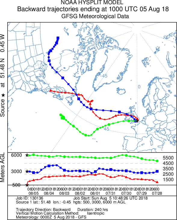
One way to find the windshear layer is look for a loop in the hodograph
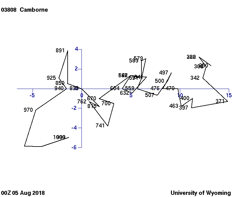
The Camborne ascent shows one at ~600 hPa which Martin has already identified. Back trajectory analysis (NOAA HYSPLIT model) shows that the mid-level airmass originates from over Canada whereaes the higher airmass comes from a lower latitude source associated with the weak mid-latitude jet.


It's notable that the boundary layer air in the west also originates over Canada as well and airmass sources throughout the depth of the troposphere are now westerly in origin. The OOZ 300 hPa analysis has an arctic jet streak over the Labrador Sea which is presumably the immediate trigger for the regime change over the whole UK later this week.
Smartie
Aug 5, 2018, 6:54:43 AM8/5/18
to Weather and Climate
Actually even in hot & humid :London parcel origins are similar. Boundary layer here has undergone some subsidence and considerable warming (~5K) in past day or two.
Reply all
Reply to author
Forward
0 new messages