Skip to first unread message

Len W
Aug 20, 2019, 6:37:50 PM8/20/19
to Weather and Climate
Don't you just love the Daily Excess headlines.
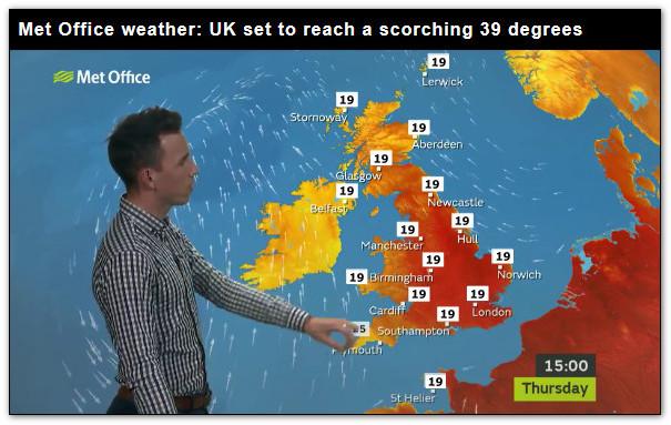
Apparently a scorching 39 degrees is on the way.
Is this fake news or a real Met Office forecast?
Len
Wembury

Freddie
Aug 21, 2019, 5:21:02 AM8/21/19
to Weather and Climate
That looks like the chart for Thursday 25th July. It'll warm up, but the rest is fake news.
--
Freddie
Dorrington
Shropshire
115m AMSL
http://www.hosiene.co.uk/weather/
Stats for the month so far: https://www.hosiene.co.uk/weather/statistics/latest.xlsx
Freddie
Dorrington
Shropshire
115m AMSL
http://www.hosiene.co.uk/weather/
Stats for the month so far: https://www.hosiene.co.uk/weather/statistics/latest.xlsx

xmetman
Aug 21, 2019, 5:29:06 AM8/21/19
to Weather and Climate
What heatwave?

Graham Easterling
Aug 21, 2019, 6:18:10 AM8/21/19
to Weather and Climate
Why is everywhere 19C apart from 15C over Cornwall, which is a good 2C below the SST? Currently (11:10) 16-18C at Culdrose, Newquay & Scilly hilltop airports, 18.5C down in Penzance
Just fake news from across the Tamar to sabotage the Cornish tourist trade. Porthcressa Scilly 11:15 (Yes, I know Scilly is not part of Cornwall)
Graham
Penzance
Freddie
Aug 21, 2019, 8:23:29 AM8/21/19
to Weather and Climate
On Wednesday, 21 August 2019 11:18:10 UTC+1, Graham Easterling wrote:
Why is everywhere 19C apart from 15C over Cornwall, which is a good 2C below the SST? Currently (11:10) 16-18C at Culdrose, Newquay & Scilly hilltop airports, 18.5C down in Penzance
Photoshop (or equivalent) :-)
Graham Easterling
Aug 21, 2019, 10:51:43 AM8/21/19
to Weather and Climate
Photoshop (or equivalent) :-)
Yes I did realise that, but why pick on Cornwall!!
A coolish maximum of 19.6C today, just 0.2C warmer than yesterday or 0.7C cooler than Monday. Still warming up a bit from now on.
Graham
Penzance

Brian Wakem
Aug 21, 2019, 11:59:20 AM8/21/19
to Weather and Climate
I think you'll find the Cornwall temp is 25C as it's the only temperature that hasn't been altered.
Len W
Aug 21, 2019, 12:09:19 PM8/21/19
to Weather and Climate
Well not 39°C, but Met Off are suggesting 33°C in the SE, so this would be a record for Aug Bank holiday.
Only forecast 21°C here in maritime Wembury.
Len
Graham Easterling
Aug 21, 2019, 12:26:22 PM8/21/19
to Weather and Climate
Thanks, that's relief.
Graham
Penzance
Freddie
Aug 21, 2019, 1:01:19 PM8/21/19
to Weather and Climate
On Wednesday, 21 August 2019 17:09:19 UTC+1, Len W wrote:
Well not 39°C, but Met Off are suggesting 33°C in the SE, so this would be a record for Aug Bank holiday.
Crikey - that's a bit brave. Bearing in mind that this hot spell will be the result of an upper trough disruption to the west of the UK (said upper trough is forming over the USA at the moment) then I might wait until I could see the whites of its eyes without a pair of binoculars.

Len
Aug 24, 2019, 3:00:07 PM8/24/19
to Weather and Climate
21C forecast.
So why have we reached 28C here today?
That is some forecast error by Met Office.
At least the model got the rain (ie none) forecast correct.
No good on trajectory of warm air though.
Must try harder. :-)
Len
Wembury

Julian Mayes
Aug 25, 2019, 1:07:11 PM8/25/19
to Weather and Climate
I have a lot of sympathy with forecasters judging fine differences in wind direction when they have such a huge influence on temperature - even in south Devon! I suppose on a bank holiday the same can be said for judging the movement of areas of sea fog around coasts - and the threat of it first burning back to sea and later drifting onto beaches as sea breezes develop. And then we hear reports of traffic congestion as people try to get to the misty coast.
Forecasting ovnt min temp in this kind of weather must be easier though in these days of good MOS forecasts. Yesterday I saw a Sky News forecast with a min temperature over London of 20C which I thought was decidedly high. The BBC showed 16C (it might have been 15C).
So, here's what actually happened ........... St James' Park min 16.7C Heathrow 16.3C In the rather chilly semi-rural / frost hollow-type sites of Kew Gardens, Teddington and Northolt we have 13-14C. I suppose the MOS temps used by all are for Heathrow - on the reasonable assumption that it's more representative of where people actually live in our crowded capital than the middle of open spaces. In a time of warmer summers isn't it ironic that it is the warm inner London that is experiencing a population boom (where heat is retained ovnt) rather than the outermost suburbs?
Julian
Reply all
Reply to author
Forward
0 new messages