Skip to first unread message

Len Wood
Nov 7, 2016, 3:55:38 PM11/7/16
to Weather and Climate
The stratospheric polar vortex looks more normal now.
Will it be disrupted as many have suggested giving us some severe winter weather?
Trouble is the easterly phase of the QBO gives a better chance of sudden stratospheric warming events and cold winters in N. Europe.
The easterly phase of QBO has not happened.
The polar atmosphere does not know whether it is coming or going.
Len
Wembury

Smartie
Nov 7, 2016, 4:39:54 PM11/7/16
to Weather and Climate
I think the fundamental problem is that the polar vortex remains displaced off the pole,. to me this plot shows it better

Another big pulse of warm air injection into the vortex is occurring ATM east of Greenland
http://www.pa.op.dlr.de/arctic/ecmwf.php?im=10

Paul Garvey
Nov 8, 2016, 2:40:58 AM11/8/16
to Weather and Climate
The point Lennis making, correctly I think, is that it is, presently, no longer split. From the stuation 1-2 weeks ago, it is closer to 'normal'. What will happen over the corse of the winter, is truly moot.
Smartie
Nov 8, 2016, 4:12:32 AM11/8/16
to Weather and Climate
Well there is still a dipole, or tripole, in the lower stratosphere-

Nevertheless one would indeed expect the anomaly higher up to propagate downwards. Split vortex anomalies tend to propagate into the troposphere, whilst displaced vortex anomalies tend not to, though the models are poor at predicting this with skill. A displaced vortex, in the present way, would allow cold air into North America and does not favour northern/Scandanavian blocking.. In the N Atlantic sector the displaced PV gradient favours a more baroclinic regime and a positive trend in the NAO. But given the weakness of the polar vortex the poleward heat transport can only serve to keep the vortex weak. It is interesting that in the short term the regime forecast for the N Atlantic is +ve NAO but some weight is also given to Scandanavian blocking in the short-medium term. Perhaps this is the contrasting influence of the displaced vs split vortex signals in the model?
The message for DJF , to me, is that the polar vortex is in a weakened state and not likely to recover soon and this surely must favour a tendency to northern blocking in some form in the coming winter.
Len Wood
Nov 8, 2016, 5:35:00 AM11/8/16
to Weather and Climate
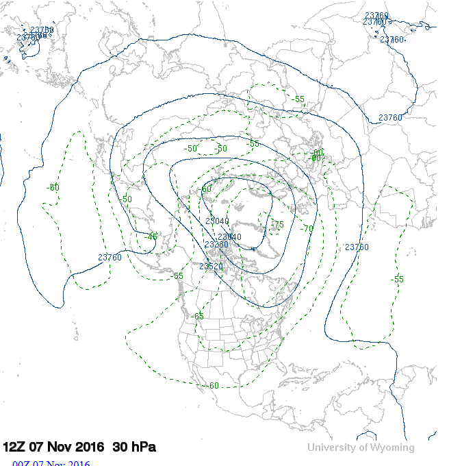
The vortex appears disrupted at 100hPa and shows a more familiar quasi-4-wave pattern.
It is seldom centred on the pole, but the degree of displacement and asymmetry may be crucial for cold plunges if the pattern becomes stationary.
Whether this happens is hard to predict and depends on the relative magnitudes of the phase speed of the waves and the zonal wind speed.
Phase speeds can be between -10 and -40 m/s (east to west) for waves of wavelength 5000 to 10000 km, so any zonal (westerly) wind speed matching that can lead to blocking.
The numerical models certainly struggle with the connections and feedbacks between troposphere and stratosphere.
I was a bit surprised to read in a recent paper about the QBO in Geophysical Research Letters:
'While the basic fluid-dynamical mechanism of the QBO is firmly established through analog studies in the laboratory, the details, especially of wave forcings, are not well understood.'
Surely QBO is forced by something, I had not realised (and doubt), it is well understood.
Can they really reproduce a 28-month cycle in the lab? I suppose they are happy with the scaling.
The paper is worth a look.
http://onlinelibrary.wiley.com/doi/10.1002/2016GL070921/full#references
Len
Wembury
It is seldom centred on the pole, but the degree of displacement and asymmetry may be crucial for cold plunges if the pattern becomes stationary.
Whether this happens is hard to predict and depends on the relative magnitudes of the phase speed of the waves and the zonal wind speed.
Phase speeds can be between -10 and -40 m/s (east to west) for waves of wavelength 5000 to 10000 km, so any zonal (westerly) wind speed matching that can lead to blocking.
The numerical models certainly struggle with the connections and feedbacks between troposphere and stratosphere.
I was a bit surprised to read in a recent paper about the QBO in Geophysical Research Letters:
'While the basic fluid-dynamical mechanism of the QBO is firmly established through analog studies in the laboratory, the details, especially of wave forcings, are not well understood.'
Surely QBO is forced by something, I had not realised (and doubt), it is well understood.
Can they really reproduce a 28-month cycle in the lab? I suppose they are happy with the scaling.
The paper is worth a look.
The quasi-biennial oscillation of 2015–2016: Hiccup or death spiral?
http://onlinelibrary.wiley.com/doi/10.1002/2016GL070921/full#references
Len
Wembury

Joe
Nov 8, 2016, 6:24:25 AM11/8/16
to Weather and Climate
I am well out of my depth here with regard to understanding the polar vortex, its behaviour and impact but very thankful for the excellent analysis and deliberations of Len and Smartie.
A very good thread in the making here.
Joe
Smartie
Nov 8, 2016, 8:44:55 AM11/8/16
to Weather and Climate
It looks like you need very high vertical resolution in the UT/LS region see-
Thanks for the link to the Dunkerton paper, which I think looks illuminating. I was a bit surprised by the loose language, but I guess it is a 'comment'. It seems the QBO is an emergent property of the dynamics rather than a fundamental dynamical mechanism - if I've got that right (?)
Geller, M. A., Zhou, T., Shindell, D., Ruedy, R., Aleinov, I., Nazarenko, L., Tausnev, N.L., Kelley, M., Sun, S., Cheng, Y., Field, R.D. and Faluvegi, G. (2016), Modeling the QBO – Improvements Resulting from Higher Model Vertical Resolution. J. Adv. Model. Earth Syst.. doi:10.1002/2016MS000699
to get a realistic looking QBO, but it may be rather telling that they have to tune the wave flux to get the right result..Thanks for the link to the Dunkerton paper, which I think looks illuminating. I was a bit surprised by the loose language, but I guess it is a 'comment'. It seems the QBO is an emergent property of the dynamics rather than a fundamental dynamical mechanism - if I've got that right (?)
Smartie
Nov 11, 2016, 5:16:39 AM11/11/16
to Weather and Climate
I wasmoved to have another go at summarising the situation for myself this morning. Comments welcome.
Despite the return of some mobility in the N Atlantic I think things remain interesting and possibly very unusual. Unfortunately the regime cluster forecasts have ceased updating but the last available suggests a near +ve NAO for the forseeable medium range albeit with HP to the W/SW. It's probably more relevant to take a hemispheric view:
-PVX (Polar Vortex) remains split in the lower stratosphere but is a more displaced vortex type higher up. Presumably the displaced vortex will try to propagate downwards although it's still early in the season and model predictability is low. If this can propagate into the UT-LS region mostly likely outcome for a displaced vortex is trans-polar flow and cooling in N America, which in turn may reinforce the jet and keep the NAO near +ve.
-looking at animations of plots of NH PV (Potential Vorticity) and theta it seems to me the PVX has been trying to establish consistent 4-5 wave number flow, after the dominance of wave number ~2, but is being thwarted by further injections of warm air eg. east of Greenland. The hemispheric blocking index -
http://www.atmo.ariz...elon-block.html
indicates a renewal of blocking east of the meridian after the most recent 'injection' which now forms a pool of tropospheric origin air between Greenland and northern Russia- seen as a ridge in GPH at ~100 hPa. The weak PVX has been a feature of this autumn and ATM I can't see a strong polar night vortex forming.
-snow cover over Eurasia is still running above 'normal' and is moving westwards as expected. It seems Stockholm has just had a record November snowfall-
https://groups.googl...her/jRGKRMoatpg
(thanks to Colin Youngs)
- ENSO still forecast to be weak -ve or neutral this winter.
- QBO service now returned to normal and a westerly phase so this a 'missing ingredient' for a really cold blocked winter in NW Europe.
There is a more detailed discussion by Judah Cohen, to which I'm indebted , here-
http://www.aer.com/s...tic-oscillation
It will interesting to see post-event analysis showing how unusual or unprecedented this autumn's NH circulation really has been.
On the climate change point all this seems consistent with running into a solar minimum, anthropogenically forced low sea ice in the Barents - Kara Sea (ie. low level heating and poleward wave propagation in that region), relatively weak SST gradients in the N Atlantic and a displaced PVX over Eurasia- all of which have been discussed in the recent scientific literature.
Joe
Nov 11, 2016, 8:54:32 AM11/11/16
to Weather and Climate
Thanks for your thoughts on this. I must take time to read more carefully when I have the chance!
Do you give any weight to the influences of a quietening sun or SST cold anomaly in Atlantic which is not so pronounced as it had been? There's also the SST anomaly south of Alaska which i believe has also shifted away from its earlier pattern?
Joe
Len Wood
Nov 11, 2016, 2:36:02 PM11/11/16
to Weather and Climate
The website link below shows an animation of the 250 hPa flow at 6 hourly intervals over the last 10 days.
It shows the contortions associated with the free waves (depressions) embedded in the hemispheric flow.
It shows what has happened at this level over the period of the split vortex in the stratosphere above, but not why.
The last frame, 12Z today 11 Nov, shows the zonal (westerly) nature of the jet stream across the N. Altlantic.
Making a bee line for us and hence the mild weather forecast for the next few days.
http://www.esrl.noaa.gov/psd/map/images/avn/250_wnd_anl.avn.anim.html
Len
Wembury
Smartie
Nov 11, 2016, 4:16:10 PM11/11/16
to Weather and Climate
On Friday, November 11, 2016 at 1:54:32 PM UTC, Joe wrote:
Do you give any weight to the influences of a quietening sun or SST cold anomaly in Atlantic which is not so pronounced as it had been? There's also the SST anomaly south of Alaska which i believe has also shifted away from its earlier pattern.
I've no idea what weight should be given but Scaife et al, for instance, include a representation of solar influence in their numerical long-range forecastes. A weakened SST gradient suggests a weaker thermal gradient and less baroclinicity in the N Atlantic ie.weaker storm track.
If you mean the 'cold blob' in the NE Pacific that's disappeared see-
and there's a striking SST gradient contributing to the strong Pacific jet (and downstream in the Atlantic?)- see Len's post.
Smartie
Nov 14, 2016, 3:48:43 AM11/14/16
to Weather and Climate
Dipole appeared again at 30 hPa with another large incursion of warm air in our sector.


Richard Dixon
Nov 14, 2016, 4:39:54 AM11/14/16
to Weather and Climate
Keep em coming Smartie - this is fascinating. Models seem to want to get a bit "flabby" by next week. EC has an interesting easterly to our west (suspect that might be gone by the next run..!)
Richard
Smartie
Nov 14, 2016, 6:11:13 AM11/14/16
to Weather and Climate
I guess that would fit with the 10-14 day life cycle of the NAO.
There is an interesting discussion of the differences of the propagation of the anomalies between the weak and strong polar vortex here-

MartinR
Nov 14, 2016, 10:50:01 AM11/14/16
to Weather and Climate
I always find it puzzling why the wispy, nebulous traces of air wafting around in the stratosphere should have any influence on weather at the surface. It can't be momentum transferring downwards.
If momentum is maintained even a 200kt jetstream at 200mB could only produce a 40kt gale at the surface where the air is 5 times denser and therefore 5 times heavier.(my simplistic physics suggests an inverse proportion).
Is it that the wispy, nebulous stuff high up reacts more quickly to atmospheric changes due to uneven heating etc, and that this predicts the way things will develop lower down?
MartinR
Smartie
Nov 14, 2016, 12:40:37 PM11/14/16
to Weather and Climate
On Monday, November 14, 2016 at 3:50:01 PM UTC, MartinR wrote:
I always find it puzzling why the wispy, nebulous traces of air wafting around in the stratosphere should have any influence on weather at the surface. It can't be momentum transferring downwards.
As I recall the reverse problem was talked about a while back- how does the troposphere influence the stratosphere ?
This was called the 'Stratospheric Flywheel Problem' but I think wave driving by upward propagating Rossby Waves is the accepted mechanism these days, although I see another idea has been put forward in an accepted paper at QJ.
The problem of downward influence is easier to understand if you adopt the all singing/all dancing PV (Potential Vorticity) view where isentropic PV anomalies in the stratosphere have non-local effects , but I believe other mechanisms have been proposed. The PV view is attractive as we know that UT/LS PV anomalies are involved in, for instance, extratropical cyclogenesis or deep convection so this is a direct route in which the stratosphere can influence weather.
Smartie
Nov 27, 2016, 4:26:55 AM11/27/16
to Weather and Climate
27 November 2016
Just to draw attention to:
- continuing warm air advection in the sector east of Greenland
Just to draw attention to:
- continuing warm air advection in the sector east of Greenland

- displaced polar vortex/ Eurasian high in depth


Reply all
Reply to author
Forward
0 new messages