Skip to first unread message

xmetman
Jun 24, 2019, 8:25:55 AM6/24/19
to Weather and Climate
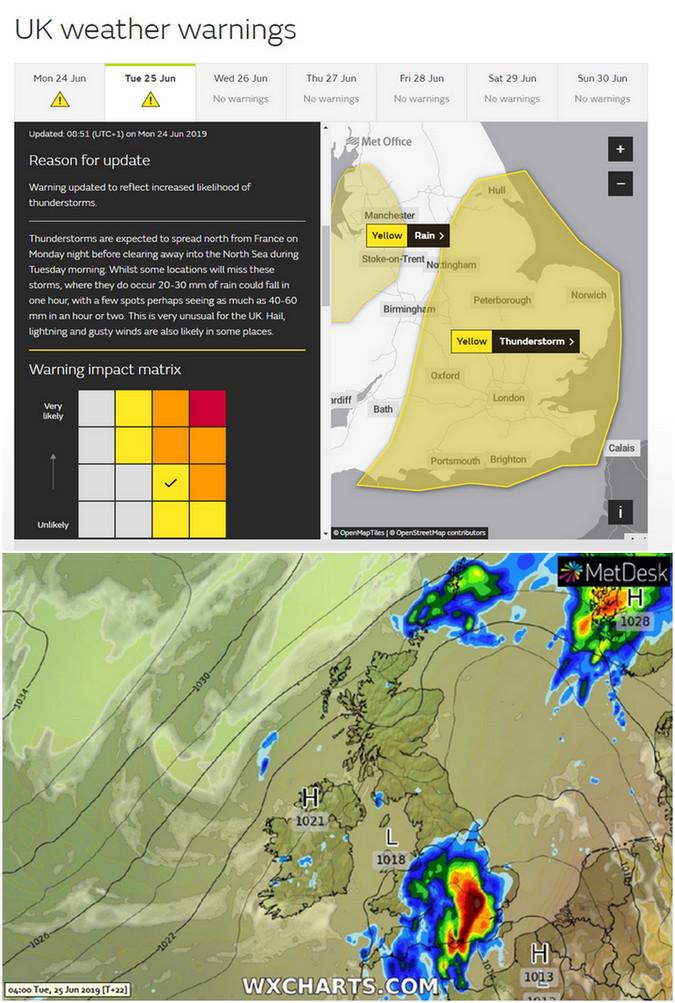
It's rather surprising that the heavy thundery rain doesn't merit more than a yellow warning from the Met Office.
The text of the warning does lay it on pretty thick, but you would have thought 40-60 mm in an hour or two would bump it up to amber.
Perhaps the GFS model is out of kilter with the UKMO model.

Freddie
Jun 24, 2019, 12:16:50 PM6/24/19
to Weather and Climate
The impact matrix says it all - it is more unlikely than likely, but if it does occur then it will have a high impact. That's why it is a yellow.
--
Freddie
Dorrington (but currently in Llandudno)
--
Freddie
Dorrington (but currently in Llandudno)

Julian Mayes
Jun 24, 2019, 12:33:25 PM6/24/19
to Weather and Climate
Although it is very oppressive down here in the South East, under full cloud cover for most of the day, we have only reached 24C. Do we really have the trigger to generate the uplift needed for dramatic storms, looking at the radar over N France right now?
I'd rather be in N Scotland at 10C though - here there's no breeze to relieve the feeling of humidity and the cloud cover gives a claustrophobic feeling. It was a pleasure to be in a supermarket earlier, not something I often say! A stormy night would add interest, but I have my doubts about it developing.
Julian
Molesey

Brian Wakem
Jun 24, 2019, 12:46:24 PM6/24/19
to Weather and Climate
On Monday, 24 June 2019 17:33:25 UTC+1, Julian Mayes wrote:
Although it is very oppressive down here in the South East, under full cloud cover for most of the day, we have only reached 24C. Do we really have the trigger to generate the uplift needed for dramatic storms, looking at the radar over N France right now?
I'm far from a convective expert, but as I understand it, the storms coming our way will not be surface based in the UK, so the temperature at the surface in the UK is irrelevant.
--
Brian Wakem
Lower Bourne, Farnham, Surrey
http://www.brianwakem.co.uk/weather
Live obs @ 17:45:04 : 22.8C, DP 18.1C, RH 75%, 0.0 mm
Julian Mayes
Jun 24, 2019, 3:08:04 PM6/24/19
to Weather and Climate
Ah yes, now that I've had a look at 2 or 3 useful posts on UKWeatherworld, I appreciate the elevated nature of the potential storms - and the said posts also highlight the role of mid-level vertical motion / vorticvity, descent placed over the south of England this pm., but moving north. And a look at the Normandy area on the radar suggests that it is getting quite active down there now.
Julian
xmetman
Jun 25, 2019, 6:01:05 AM6/25/19
to Weather and Climate
Not easy to get right but the yellow warning looks to have been extended too far west.
Reply all
Reply to author
Forward
0 new messages