Skip to first unread message

Len W
May 19, 2022, 11:32:52 AM5/19/22
to Weather and Climate
I
have done a sample verification of forecast maximum temperatures for Plymouth
in May. The model output nearly always gives temperatures below those
which occur. I have highlighted in red those forecasts that were 2
degrees or more in error.
This is not unusual IMHO.
Issued Fri. 6th May

Len
Wembury

Graham Easterling
May 19, 2022, 4:01:08 PM5/19/22
to Weather and Climate
I've did a similar thing in April. Over a 10 day period the UKMO forecast maximum, 1 day ahead, averaged 2.7C too low. I would say that's normal for Spring, early Summer.
BBC is around 1C warmer than UKMO, on average. It is also, overall, less gloomy & more accurate when it comes to cloud cover.
The next 3 days forecast maximum temperature for Penzance
UKMO 16C, 15C, 15C (The wind is forecast to be SW to W over Saturday, Sunday, so not even onshore in SE-E facing Penzance/Newlyn.)
BBC 16C 17C 17C
Yesterday's UKMO for today was 14C (upped to 15C during this morning). It reach 16.6C, so about par.
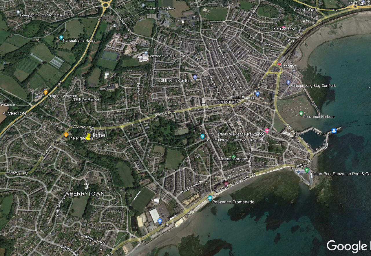
I think my site is fairly typical for Penzance. When the official Penzance site was in operation, I was in very close agreement with the figures. Monthly averages were normally well within 0.5C of each other. I am about 400m from the old official site. 600m from the sea, 19m AMSL, similar to the old official site.
For anyone interested
Graham
Penzance
Graham Easterling
May 20, 2022, 4:59:02 AM5/20/22
to Weather and Climate
. . . It reach 16.6C
It actually reached 16.8C.
Minimum of 13.0C last night, 15.3C at 09:00, both figures almost identical to Scilly.
The SST in the SW approaches is now 1.5C above normal. The 14C isotherm was close to Scilly, W/E 14th May (source NCEP/NOAOA), which is exceptionally warm. I wonder if the high SSTs are fully taken into account in the UKMO forecasts? Currently 14.2C at the Penzance buoy. This despite all the mixing in the recent big seas.
Graham
Penzance

Freddie
May 20, 2022, 5:29:12 AM5/20/22
to Weather and Climate
On Friday, 20 May 2022 at 09:59:02 UTC+1 Graham Easterling wrote:
The SST in the SW approaches is now 1.5C above normal. The 14C isotherm was close to Scilly, W/E 14th May (source NCEP/NOAOA), which is exceptionally warm. I wonder if the high SSTs are fully taken into account in the UKMO forecasts? Currently 14.2C at the Penzance buoy. This despite all the mixing in the recent big seas.
There has been a very recent (in the last month) change to use ocean/atmosphere coupled model. Before this change, the SST used to be constant through the forecast period at the assimilated value at analysis. After the change, the SST evolves as the ocean model evolves.
--
Freddie
Alcaston
Shropshire
148m AMSL
http://www.hosiene.co.uk/weather/
Stats for the month so far: https://www.hosiene.co.uk/weather/statistics/alcaston/latest.xlsx
Freddie
Alcaston
Shropshire
148m AMSL
http://www.hosiene.co.uk/weather/
Stats for the month so far: https://www.hosiene.co.uk/weather/statistics/alcaston/latest.xlsx
Graham Easterling
May 20, 2022, 6:01:05 AM5/20/22
to Weather and Climate
Thanks for that
Graham
Len W
May 20, 2022, 6:01:00 PM5/20/22
to Weather and Climate
the SST evolves as the ocean model evolves ?
I wonder how this happens when the forecast timescale we are talking about is only for one week ahead.
The atmosphere over this timescale is driving the surface layer of the ocean.
Is the SST changing that quickly so as to be important in the NWP?
I have n't noticed it on the satellite derived SSTs.
Len
Wembury
Graham Easterling
May 21, 2022, 7:17:53 AM5/21/22
to Weather and Climate
I think, in the open ocean, SST normally changes very slowly. An exception being a sharp drop when very disturbed weather sets in after a prolonged anticyclonic period, causing extensive mixing. Many satellite derived SST reports are averaged over a week, I believe.
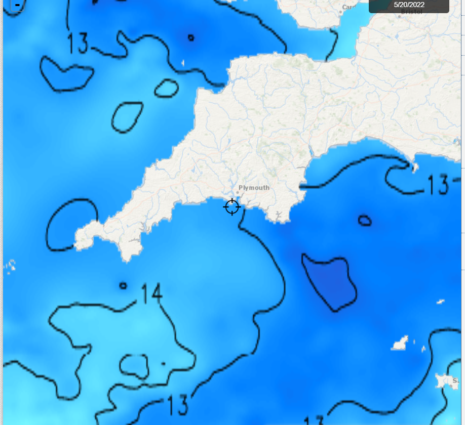
Inshore, the SST is highly dependent on the prevailing wind direction, as anybody who regularly goes in the sea will know only too well! I used to record the temperature off the Battery Rocks in Penzance, at it could drop 4C in one day after a prolonged gentle onshore wind turned offshore NW and caused cold water to upwell. Even over a quite an extensive area in a large bay like Mount's Bay, wind direction can affect the SST, and therefore the temperature of a sea breeze, by a couple of degrees.
Current inshore SSTs, showing the particularly warm water off the S Cornish coast.
The colder coastal edge to the north coast largely due to mixing in the recent big swell. The north Devon area is often a bit cold (tidal mixing?) but also they've had of offshore winds of late
This comes from a fishing site ( http://www.fishtrack.com/fishing-charts/southwest-england_63165 ), and it is surprising how much the SST flutuates, not just on the beaches, but for several miles offshore.
None of this explains why the UKMO forecast temperature for Plymouth & Penzance is consistently a good 2C low. Forecast for Penzance today is still 15C. Currently 16.5C & rising, cloud broken
Graham
Penzance
Graham Easterling
May 23, 2022, 4:41:15 AM5/23/22
to Weather and Climate
The next 3 days (Fri/Sat/Sun) forecast maximum temperature for Penzance
UKMO 16C, 15C, 15C (The wind is forecast to be SW to W over Saturday, Sunday, so not even onshore in SE-E facing Penzance/Newlyn.)
BBC 16C 17C 17C
FRI SAT SUN
ACTUAL 17.8C 17.6C, 19.3C (warmest day of 2022)
Rounding to the nearest degree , MetO error -2C, -3C, -4C.
Looking at the UKMO forecast for Penzance @ 09:00 yesterday, the days forecast maximum was still only 15C for Penzance, everywhere else in west Cornwall was higher including the seafront exposed heliport & Lands End (both 16C). It was also predicted to be cloudy cloudy all day, when the satellite imagery showed us well to the south of the solid frontal cloud. In fact prolonged strong sunshine from 11:00 until 17:00. UV hit 8 at Camborne, about as high as it gets. (Warm sector humid air essentially).
It did look as if the maximum would be close to 18C, but mid afternoon the wind veered SW, the air descending from the hills above Newlyn, resulting in a late rise to 19.3C, the warmest day of the year beating 19.1C earlier in the month. The veer in wind was forecast days ago, but no account taken in the temperature forecasts.
There have been problems with wrong grid references being used for 5 day forecasts. E.g. 2 different references used for the Scilly airport & heliport when they are the same place. (I was told this by UKMO, as an explanation as to why the forecasts were different!) Porthmeor (N facing) and Porthminster (east facing). I suggested the person I was dealing with looked at Google Earth. The Penzance forecasts tend so low, I wonder if a grd reference offshore is being used?
Graham
Penzance
On Thursday, 19 May 2022 at 21:01:08 UTC+1 Graham Easterling wrote:
Reply all
Reply to author
Forward
0 new messages