Skip to first unread message

xmetman
Jul 29, 2019, 5:46:32 AM7/29/19
to Weather and Climate
It's always puzzled me why the Met Office makes no effort to display a chart of the sea surface temperatures around the coast of this sceptred Isles on it's website.
After all we are a group of islands in the eastern North Atlantic ocean and have always been proud to be called a seafaring nation.
A chart of the latest SST around these waters you thought might be come in handy for the fishing industry or any holidaymaker venturing in for a dip.
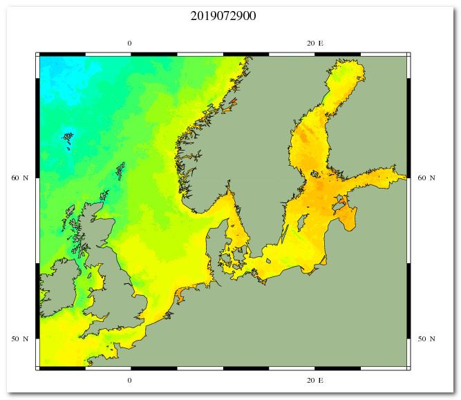
If the Met Office do have a chart of the latest SST then I've never seen it. So when I spotted the SST chart from the Danish Meteorological Institute [DMI] I immediately added it to my favourites - it's not perfect for the British Isles but beggars can't be choosers - the question is why do we have to rely on the DMI to see the sea temperatures around our own coastline and not our own Met service?


Freddie
Jul 29, 2019, 6:02:12 AM7/29/19
to Weather and Climate
There is one: https://www.metoffice.gov.uk/public/weather/forecast/map#?map=Temperature&zoom=5&lon=-4.00&lat=55.01&fcTime=1564347600
Might be easier if you navigate to it though (Maps & Charts > UK Weather Map, then select Temperature Map) as the above URL will give the same map every time (note the fcTime parameter). I know it is a forecast, but it is heavily influenced by current data from surface-based and remotely-sensed observations.
--
Freddie
Dorrington
Shropshire
115m AMSL
http://www.hosiene.co.uk/weather/
Stats for the month so far: https://www.hosiene.co.uk/weather/statistics/201907JUL.xlsx
Freddie
Dorrington
Shropshire
115m AMSL
http://www.hosiene.co.uk/weather/
Stats for the month so far: https://www.hosiene.co.uk/weather/statistics/201907JUL.xlsx
xmetman
Jul 29, 2019, 6:09:30 AM7/29/19
to Weather and Climate
I've found another one...
xmetman
Jul 29, 2019, 6:16:46 AM7/29/19
to Weather and Climate
I'm not certain that's the SST, it looks more like the temperature at 2M it's displaying Freddie when compared to the DMI chart. And why only contour at 15°C?
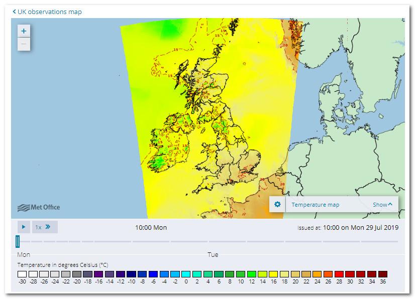
It has plenty of detail if you zoom in but it's confined to a very small bounding box.


Graham Easterling
Jul 29, 2019, 7:21:13 AM7/29/19
to Weather and Climate
Just about any decent surf site has one.
On the great Magic Seaweed
or non surf site
in fact there are quite a few.
However, they are little guide to temperature over the beaches, which are so dependent on whether the wind's onshore (warm) or offshore cold, as well as whether the sun's out. I've recorded 20C off the Battery Rocks, Pz, one day during a sunny afternoon with an onshore breeze piling in the warm surface water, near 15C the next in a moderate NW wind with upwelling.
This is a good site for SST inshore, even these can show some quite large day to day variations.
using Penzance as an example
Also, there a lots of buoys out there of course.
Graham
A very wet & windy Penzance - perhaps some thunder at last?

Dave C
Jul 29, 2019, 8:05:17 AM7/29/19
to Weather and Climate
Thanks for the links. Unless my browser is playing up the UKMO can't even display the rainfall radar this morning. For the record and as usual the opposite to you, a glorious sunny day with pleasant mid twenty temperatures. I best enjoy it before tomorrow!

Brian Wakem
Jul 29, 2019, 8:08:03 AM7/29/19
to Weather and Climate
This one shows 1 degree isotherms so gives a better picture of the actually temps:
Graham Easterling
Jul 29, 2019, 8:09:16 AM7/29/19
to Weather and Climate
This is a good site for SST inshore, even these can show some quite large day to day variations.
using Penzance as an example
the right link!!
Graham
Penzance
Freddie
Jul 29, 2019, 8:10:30 AM7/29/19
to Weather and Climate
On Monday, 29 July 2019 11:16:46 UTC+1, xmetman wrote:
I'm not certain that's the SST, it looks more like the temperature at 2M it's displaying Freddie when compared to the DMI chart. And why only contour at 15°C?
You're very likely correct that it's 2m temp - apologies for misleading.
xmetman
Jul 29, 2019, 8:37:26 AM7/29/19
to Weather and Climate
I like that one Brian and NCOF are in collaboration with the Met Office so why don't they simply use the tiles?

Len
Jul 29, 2019, 10:50:02 AM7/29/19
to Weather and Climate
This is not bad, although no anomalies and not for Scotland, sorry Bruce.
I like the contouring option.
It tells me where to look for fish.
Len
Wembury, SW Devon
Reply all
Reply to author
Forward
0 new messages