Skip to first unread message

Len W
Jun 10, 2020, 7:07:46 AM6/10/20
to Weather and Climate
Is this necessary?
Should keep the grockles at home at least.
Here is a picture of Wembury this morning. Somewhat parched.
Len

Dave C
Jun 10, 2020, 10:06:25 AM6/10/20
to Weather and Climate
Looks like the threat of heavy rain has moved significantly West overnight. Had some light rain here giving a couple of mm and expecting a little more later. However having just watched the forecast it seems to have changed to a much more settled outlook from the weekend onwards than was being predicted yesterday. Certainly no mention of the thunderstorms moving up from the south on that forecast.

Freddie
Jun 10, 2020, 10:15:12 AM6/10/20
to Weather and Climate
On Wednesday, 10 June 2020 15:06:25 UTC+1, Dave C wrote:
Looks like the threat of heavy rain has moved significantly West overnight. Had some light rain here giving a couple of mm and expecting a little more later. However having just watched the forecast it seems to have changed to a much more settled outlook from the weekend onwards than was being predicted yesterday. Certainly no mention of the thunderstorms moving up from the south on that forecast.
Such is the fun of upper trough disruptions :-)
--
Freddie
Dorrington
Shropshire
115m AMSL
http://www.hosiene.co.uk/weather/
Stats for the month so far: https://www.hosiene.co.uk/weather/statistics/latest.xlsx
Freddie
Dorrington
Shropshire
115m AMSL
http://www.hosiene.co.uk/weather/
Stats for the month so far: https://www.hosiene.co.uk/weather/statistics/latest.xlsx

Graham Easterling
Jun 10, 2020, 4:02:38 PM6/10/20
to Weather and Climate
Not that much rain here yet.
4.9mm in June up until 09:00 this morning. Approx 5mm late afternoon / evening today. Just steady really. The heaviest rain seems to be developing to the east, particularly over N Devon/Somerset as far as the SW is concerned. I wonder whether the most intense rain here turns out to be on Friday?
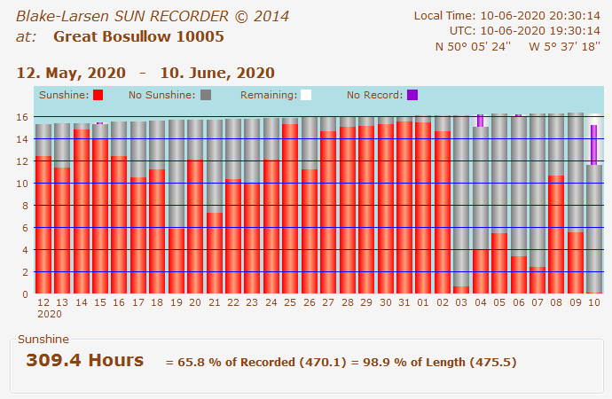
Bit of interest anyway, after a series of cool mainly dry days with limited sunshine. 30 day running sunshine total set to dip below 300 hours
Maximum temperature today 15.7C.
Graham
Penzance
Graham Easterling
Jun 10, 2020, 4:24:48 PM6/10/20
to Weather and Climate
Looking at the radar, I'm wondering if the warning area is a bit too far west.
No heavy rain here, just steady and that's currently edging eastwards. But it looks very wet in Somerset, N Devon & SE Wales.
Time will tell. Friday looks interesting to me.
Graham
Penzance Where it was a bit chilly in the garden today chatting to friends.

Smartie
Jun 10, 2020, 5:11:44 PM6/10/20
to Weather and Climate
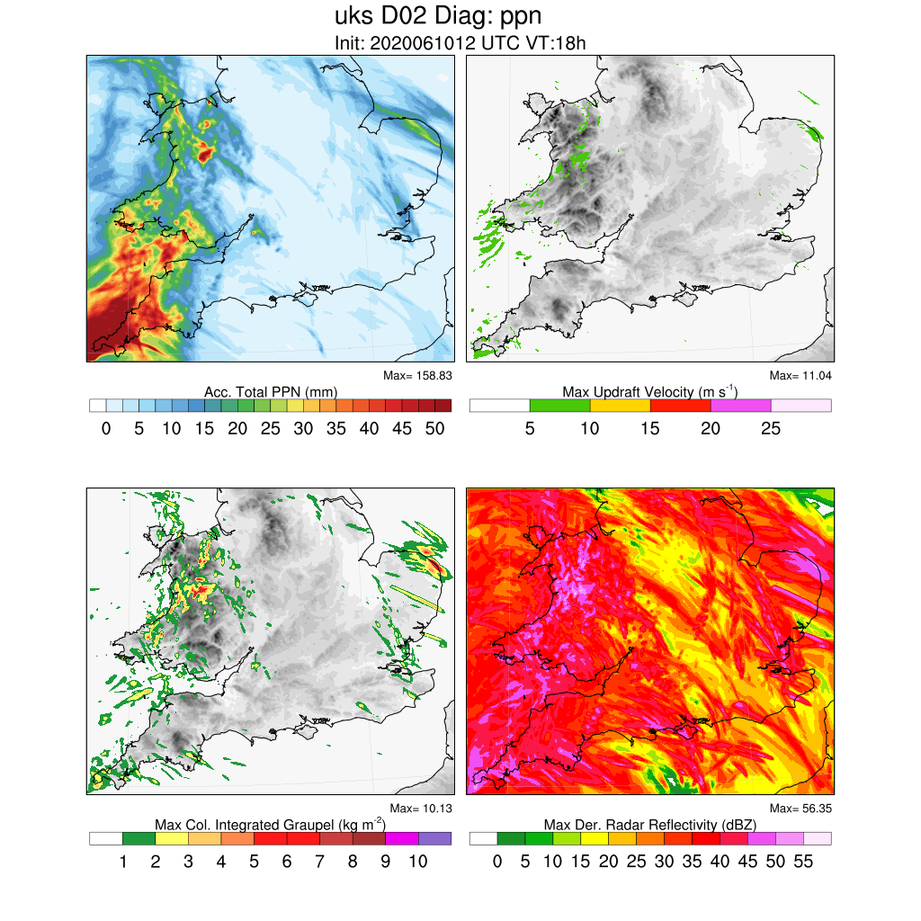
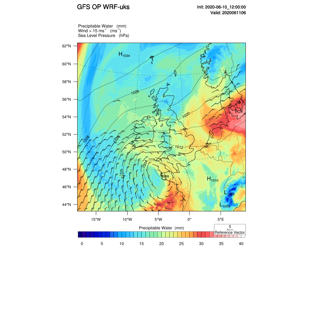
Rainfall forecast to intensify tonight with strong frontogenesis aloft (PV advection) and surface pressure deepening. Model profiles indicate >2cm precipitable water in the far SW being fed by strong advection of moisture at ~850 hPa. Forecast still raining in the far SW at O6Z tomorrow. 1.5km WRF initialised with the GFS.
Dave C
Jun 10, 2020, 6:21:13 PM6/10/20
to weathera...@googlegroups.com
Anything possible in my neck of the woods (Essex) in the next couple of days? Did get deluged with 6.5mm today with monthly total now creeping up towards a respectable 20mm.

Julian Mayes
Jun 10, 2020, 6:36:16 PM6/10/20
to Weather and Climate
On Wednesday, June 10, 2020 at 3:06:25 PM UTC+1, Dave C wrote:
Looks like the threat of heavy rain has moved significantly West overnight. Had some light rain here giving a couple of mm and expecting a little more later. However having just watched the forecast it seems to have changed to a much more settled outlook from the weekend onwards than was being predicted yesterday. Certainly no mention of the thunderstorms moving up from the south on that forecast.
Dave, I read your comment earlier but did not have a chance to check model output until just now. For those who need more rain, don't give up hope just yet. I'd rephrase your first sentence to read ' it looks like the threat of heavy rain ovnt will stay in the west as it is about to turn back west now'. After that, all a bit 'hit and miss' (as they love to say) depending on whether our localities get hit with showers or not. Friday - thunder risk does look reduced doesn't it with the front possibly weakening before it reaches us. If you check out wxcharts.com but select ECMWF HRES, Tuesday onwards look promising for more heavy showers - contrary to the impression given by the outlook symbols recently displayed on our TV screens by a leading broadcaster :) . But with slack airstreams, brightness and some warmth, it'll feel humid.
Julian
PS..........Some nearly incredible hourly rainfall totals for Mumbles (Swansea) have been reported this evening.
Hour to 19h UTC 12.8mm, then 12.2mm and 15.6mm. Last hour just 4.0mm. Otherwise wettest hours have been ~ 7mm at Bude, Culdrose and St. Athan. If this is correct at Mumbles, there may be problems later as this rain has to move back east, though heaviest seems to have moved NNW towards Carms so maybe away from Swansea area.

Len
Jun 10, 2020, 6:39:58 PM6/10/20
to Weather and Climate
Rather slow moving so would not be surprised if we get about an inch.
Not especially heavy but big drops.
Len
Wembury, SW Devon
Graham Easterling
Jun 11, 2020, 5:06:31 AM6/11/20
to Weather and Climate
26.3mm of rain here in the 24 hours to 09:00, Number 158 in my wettest days chart (Since 1991). June total now 31.2.
Never that heavy (my bedroom has a velux, so I notice!) just persistent.
My wettest June day (09:00-09:00) was 26/06/06 with 78.9mm, 76.2mm at nearby Tregwainton Gardens. One of those localised deluges the Cornwall is prone to, not all of which are reported much. St Ives was severely flooded on 25/04/09. I recorded 88mm in a 24 hour period. I was kindly provided with this analysis:-
The area west of St Ives had typically ~170mm with a maximum of 193mm ~4km SW of the town. Zennor had 136mm. However, very sharp E-W gradient with much lower totals to the East of St Ives - typically no more the 25mm. The highest totals were just offshore to the NW of the coastline with up to 200mm - however, maybe brightband played a part here - this region is ~37km from the Predannack and assuming a maximum height of the freezing level to be ~2km puts it at the 3 degree beam elevation... "
Most of these 100-200mm deluges miss the rain gauge network. Boscastle type events are not that uncommon in Cornwall, it's the geography/geology of Boscastle that adds to the problem, and that stupid NT car park built in the flood plain which made the last flood so much worse than in the 2 1950s events (which often get mistakenly combined into one event) when the river and rainfall amounts were similar. It was the cars being washed out of the car park that did much of the damage.
I think the interesting bit may still be to come.
Graham
Penzance
Julian Mayes
Jun 11, 2020, 7:30:33 AM6/11/20
to Weather and Climate
I think the interesting bit may still be to come.
You are so right Graham! :) .........
Mumbles 09-09h figure was (probably) 68.2mm
Here are the 18-06h hr figures
Mumbles 60mm
Cardinham (Cornwall) 55mm
Culdrose, Chivenor and Bude 31mm
North Wyke (nr Okehampton) and Plymouth 29mm
St. Athan 26mm
Whitechurch (Pembs.), Gogerddan (Aberystwyth), Pembrey and Okehampton (East Okement Farm) 25mm
Milford Haven, Tredegar and Haverfordwest (Scolton C. Park) 23mm
Over 60mm recorded ovnt unofficially by my old friend Mr John Powell on the other side of Mumbles. He ran the Penmaen climat. station for 50 years and in this time his wettest day was 70.1mm in August 1971 (following a 50mm + event the previous June).
Julian
Len
Jun 11, 2020, 11:16:02 AM6/11/20
to Weather and Climate
Estimated an inch but got more from the event
35.3 mm.
People were asking for a soaking and they got it.
My tops for a June 24-hr rain total is 47.5 mm on 24th June 2005
from a record that started in Wembury in 1985.
Tomorrow afternoon seems likely to have another goodly amount more.
But wot?
No yellow warning?
Len
Wembury
Reply all
Reply to author
Forward
0 new messages