Climatology Of Heat Ridges Affecting Europe And North America
503 views
Skip to first unread message

Larry Cosgrove
May 6, 2016, 3:24:34 PM5/6/16
to weather...@googlegroups.com
Climatology Of Heat Ridges Affecting Europe And North America


Definition Of Heat Ridge (also known as Subtropical High)
In order to be classified as a heat ridge (synonym: subtropical high), an anticyclone must have an identifiable core circulation or center that builds to 588dcm or greater at the 500MB level. These ridges are typically associated with daily maxima in excess of 90 deg F at surface which may continue over a period of many days, weeks, and perhaps months (in rare cases).
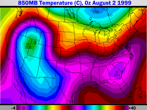
How To Look For Heat Ridge Formation On Weather Charts
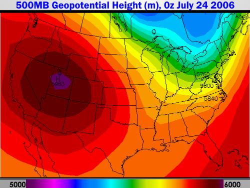
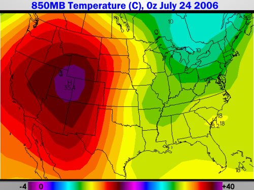
There are three synoptic charts which can tell you of a threat for serious rises in temperatures that are associated with the formation and placement of subtropical highs. As a first order of business, check the 1000-500MB thickness charts for readings of greater than 576dcm. This measurement is the distance between the mid-levels of the atmosphere and close to the surface or sea-level. Next, go the 850MB temperature forecast maps. This corresponds to about 5000 feet above surface, and is a reliable indicator of increasing heat at lower levels. When 850MB readings exceed 20 deg C, corresponding sea level readings will likely be above 100 deg F (or 95 deg F when dewpoints exceed 70 F). Then retrieve the 500MB graphics, and look for the "H" on the map with core readings above 588dcm. If a closed circulation greater than that height level is found, expression of surface hot weather will be more widespread. If the highest value in decameters exceeds 594, then a critical heat wave may occur. In rare cases, the center of the upper level high may reach or surpass 600dcm. In such cases, barring unforeseen anomalies such as sea breezes, trapped marine layers, or valley fog banks, readings may greatly surpass 100 deg F for a number of days. As a last precaution, check out the 700MB relative humidity charts to see if maximum (or at least partial) sunshine is achieved. If the demarcation is below 60 percent, then enough insolation will be present with the compressed, subsident, capped atmosphere to yield dangerous heat levels at surface.
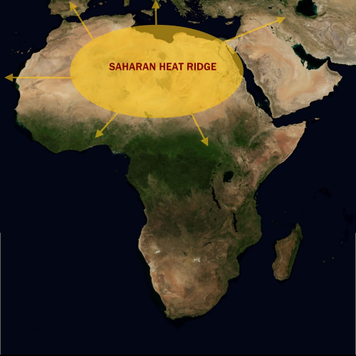
Saharan Heat Ridge
It figures that a vast desert would be the site of continued hot and dry weather. And truth be told, the Sahara Desert is, for the much if not most of any given year, the location for a semi-permanent ridge complex. Simply termed the "Saharan Heat Ridge", this anticyclone is the largest of all 500MB ridges and is the determinant for temperature and general weather trends in Europe, the Middle East, the northern half of Africa.
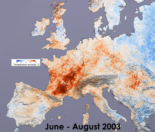
Because of the unique geography of the European subcontinent, it takes a unique combination of expansion of the Saharan heat ridge and a trough over the eastern Atlantic Ocean to produce cases of extreme hot weather in Europe. The massive, prolonged, and often fatal heat wave of June-August 2003 is a classic case of the subtropical high rimming the Mediterranean Sea with cT + mT values forced northward as far afield as the United Kingdom and Germany (France had upwards of 14,000 fatalities).
The position and strength of the positive height anomaly also affects tropical cyclone formation in summer and fall in two ways: setting up an east-to-west steering mechanism for impulses along the ITCZ and also, through imparting dry air and desert sand/dust into the disturbances, eliminating many of the waves through elimination of thunderstorms. A rule to follow, the weaker and more northward the position of the Saharan anticyclone, the better chance that any given low pressure area emerging off of western African shoreline (i.e. "Cape Verde" cyclones) will survive and intensify across warming waters over the equatorial Atlantic Ocean.
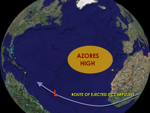
Azores High
The Azores High is a smaller heat ridge located near the island group of the same name. Unlike its larger companion ridge to the east, this anticyclone is a standard fixture only in the summer (although the circulation can turn up at any time of the year). The importance of the appearance of an Azores High is simple: if the ridge is not present, developing tropical waves will recurve northward into the cooler waters of the northern Atlantic Ocean. Also, in cases where this ridging links or becomes merged with the Saharan ridge complex, sand and dust from the desert may move westward, eliminating convection and thereby weakening or destroying ITCZ-born impulses before warm-core cyclogenesis can occur.
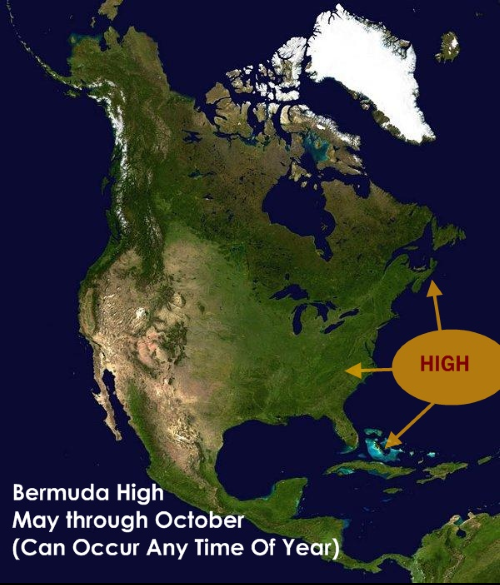
Bermuda High
By itself, the Bermuda High (centered over the Sargasso Sea or near the island commonwealth of the same name) is NOT a frequent contributor to heat waves in the U.S., although its presence favors higher temperatures and sometimes extremely high dewpoints and relative humidity. Since winds about this anticyclone pass over vast quantities of water, the resultant weather pattern is usually accompanied by unstable air with frequent bouts of diurnal or seabreeze convection (thus providing some measure of cooling in late afternoon and evening). This ridge complex is a critical player in steering and development of tropical cyclones; in the classic position any disturbance near the Greater Antilles, just north of same, will almost always strike the continental U.S. And if the SST profile is favorable (warm), the outflow capability provided by the high should enable intensification of any nearby warm-core low.
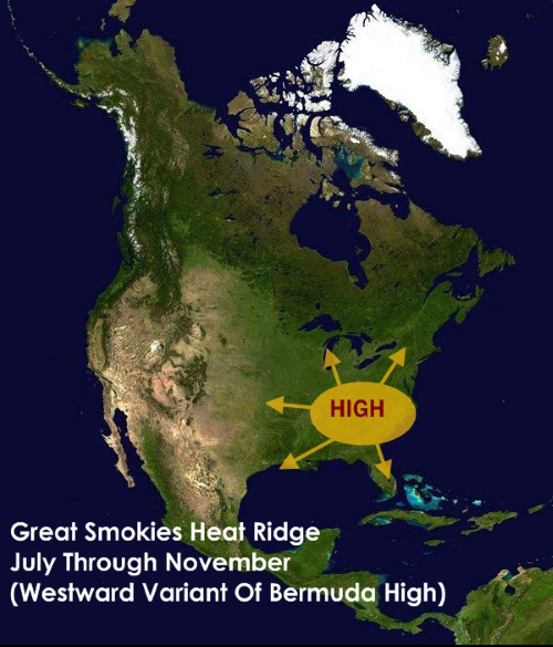
Great Smokies Heat Ridge
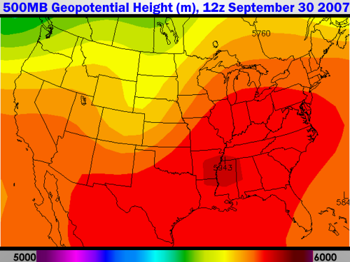
In many cases, the Bermuda High may shift westward, or bridge into an extension centered over the southeastern U.S. In such cases (common under "La Nina" episodes, such as September 2007), this type of heat ridge may last well into the fall. The lower half of the Appalachian Mountain chain is called "the Great Smokies" because early settlers saw haze and smoke trapped over the mountains as a result of stagnant high pressure. When this anticyclone is present, extremely high temperatures, air pollution, and persistent drought will result from the Mason-Dixon line to the Gulf Coast, and often westward to the Ozark Plateau.
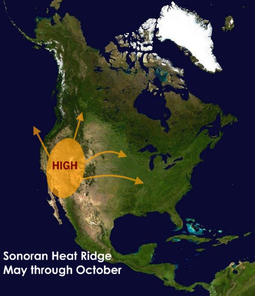
Sonoran Heat Ridge
The Sonoran heat ridge derives its name from the desert of the same name, which straddles the Mexican border with California, Arizona, and New Mexico. A critical player in summer heat waves over the Southwest, Intermountain Region, and the Great Plains, this anticyclone acts in concert with topography and the general atmospheric circulation to enhance heat and drought. If the positive height anomaly becomes situated over the Great Basin and expands westward, then the mP marine layer will stay offshore and the cities of San Francisco, Sacramento, Los Angeles and San Diego will go through an excruciating hot spell with high demands on the power grid (example: July 2006). Northward extension of the subtropical high brings unusual heat to the Pacific Northwest, while dislocation of the highest 500MB heights can render the Salt Lake Valley, Denver CO, and points eastward into the Missouri Valley a veritable furnace with blinding sunshine and parched ground.
Conjoined Anticyclones And Mega-Ridges
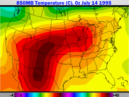
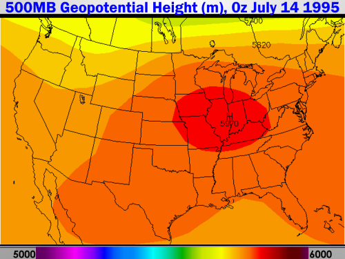
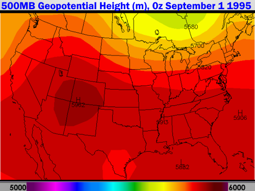
Occasionally, heat ridges may link or merge to produce extreme summer weather conditions. Outright merger of the Sonoran and Great Smokies ridges can occur, such as the infamous July 1995 heat wave which killed about 600 people in the Chicago IL metro during five days in the middle of the month. Such phasing can concentrate dry air aloft over relatively moist air in the lower levels, which produces abundant sunshine over a haze-filled, muggy atmosphere.
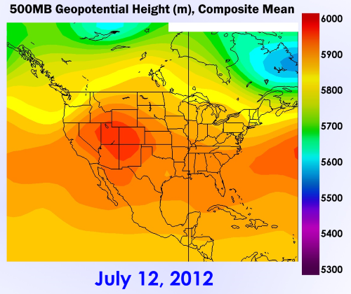
The 2012 summer produced one of the harshest national droughts on record, as the Sonoran anticyclone expanded over already dry areas of the West and Great Plains. Conjuncture with a Sargasso Sea heat ridge led to multiple cases of widespread 100 deg F weather from July into September.
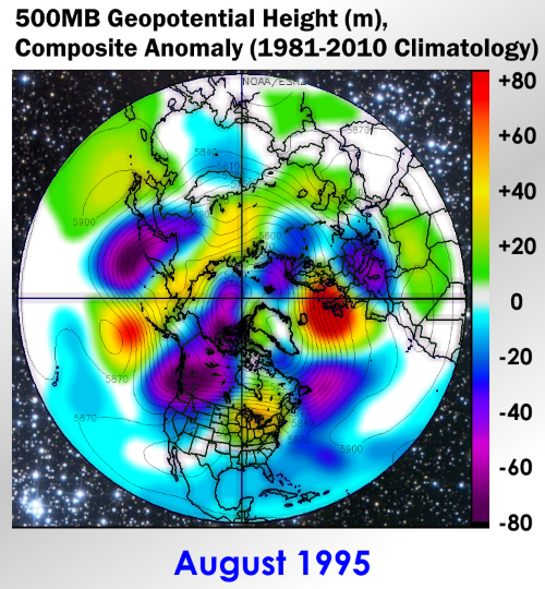
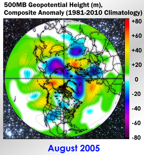
Mega-ridges straddling the tropics are more rare than conjoined subtropical highs over the continents. In high-output tropical cyclone seasons such as 1995 and 2005, heat ridges linked around the Northern Hemisphere, affording maximum potential for intensification of warm-core cyclones while promoting a westward path toward the populated islands and North America. Examining hemispheric charts at 500MB can prove to be a useful tool to determine potential for African ITCZ waves to reach the Greater Antilles, Mexico and The U.S.
Long-Lived Heat Waves
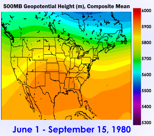
There are cases where hot temperatures may continue for an amazingly long period of time. Besides the toll on the elderly and infirm, utilities such as water and power suffer outages or curtailments. An example of a summer-long heat wave of 1980 that occurred in Dallas TX (and many other cities in the central and southern U.S.), which killed 1700 people and produced an astounding 22 straight days over 100 deg in several locations, shows several outstanding characteristics:
1) Very dry soil leading into the summer period, with rainfall diminishing quickly as the solstice approached
2) A strong, shortwave-laden jet stream running just above the Canadian border (which helped to advect Mexican desert-derived air into the U.S.
3) Entrenched deep mean easterlies that ran from the Greater Antilles into central Mexico
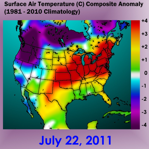
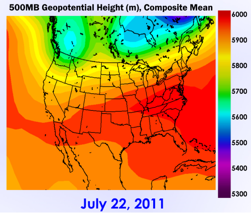
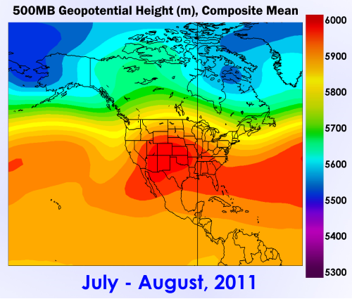
In many instance, extended periods of extreme heat involve a conjoined ridge complex that cover most of the U.S. The summer 2011 case was notable in that the core of the subtropical high routinely pulsed between the Sonoran and Bermudan positions. Note that mean 500MB heights above 585dcm essentially covered the entire nation. When the highest height anomalies were off of the East Coast (as in July 22), the Interstate 95 corridor experienced hellish heat. At other times the Great Plains, Midwest and Old South were placed in the proverbial "frying pan" as the ridge center moved into the Great Smokies and Sonoran signatures.
Keep in mind that ensemble forecasts will most often NOT show such intense heat waves, as averaging of the various model members acts to "blur" positioning of critical atmospheric heights. Use of ANOMALY charts at 500MB are often useful, helping the forecaster to determine the MOST LIKELY position and core height of the ridge in question. If ridging shows up repeatedly and at higher latitudes against strong easterly and westerly flow axes, the subtropical high may venture into critical drought and heat producing ranges.
Trans-Ridge Weaknesses
Close examination via satellite and upper air reports can determine the existence of weaknesses in 500MB heat ridges. Weaknesses (essentially a gap in the anticyclone produced by pockets of cooler air in the upper levels or an actual corridor between the two splitting halves of a ridge complex) are critical for two reasons: a) acting as a steering mechanism for tropical cyclones and other disturbances, and b) setting up thunderstorm clusters which denude the hot character of the air mass.
Reply all
Reply to author
Forward
0 new messages