Google Transit and Merged Feeds
191 views
Skip to first unread message

Paul Harrington
Nov 15, 2018, 11:13:46 AM11/15/18
to Transit Developers
Hi Guys,
I'm looking at a set of separate GTFS feeds at
Stops and stop ids are shared across feeds so when you click on some stops in Google maps and look at the transit layer departure board, the listing include departures across multiple feeds.
This suggests to me that there is some merging of the feeds referenced above. Is this something that can be done in the Google Partner Transit Dashboard ?
Or is it more likely that an integrated GTFS static feed is being referenced by the dashboard ?
Thanks Paul.
Paul Harrington
Nov 16, 2018, 10:29:55 AM11/16/18
to Transit Developers
Anybody ?? Somebody must at least have access to a Google Partner Transit Dashboard and be able to confirm whether or not there is a facility for merging GTFS feeds ?

Raj Jagad
Nov 20, 2018, 7:02:17 PM11/20/18
to transit-d...@googlegroups.com
Hello Paul
There is a Merge script on github https://github.com/google/transitfeed/wiki/Merge
Not sure if this feature is viable inside google partner Transit Dashboard
But there is another option for MergerThere is a Merge script on github https://github.com/google/transitfeed/wiki/Merge
Raj
On Fri, Nov 16, 2018 at 10:29 AM Paul Harrington <harri...@gmail.com> wrote:
Anybody ?? Somebody must at least have access to a Google Partner Transit Dashboard and be able to confirm whether or not there is a facility for merging GTFS feeds ?
--
You received this message because you are subscribed to the Google Groups "Transit Developers" group.
To unsubscribe from this group and stop receiving emails from it, send an email to transit-develop...@googlegroups.com.
For more options, visit https://groups.google.com/d/optout.

Aaron Antrim
Nov 20, 2018, 7:17:47 PM11/20/18
to transit-d...@googlegroups.com
The stops are probably all just located in the same place. Portland Union Station shows several agencies Trillium maintains in separate feeds. We locate the shared stops in precisely the same location.
Sent from my phone

Brian Ferris
Nov 20, 2018, 7:25:51 PM11/20/18
to transit-d...@googlegroups.com
Google internally attempts to merge stops/stations from different feeds that we think are referring to the same physical stop/station. They don't necessarily need to have the exact same name / location, though it certainly helps.
Paul Harrington
Nov 22, 2018, 6:12:53 AM11/22/18
to transit-d...@googlegroups.com
Thanks Raj,
I will check it out but suspect it only works for 2 versions of the same feed
Paul Harrington
Nov 22, 2018, 6:14:36 AM11/22/18
to transit-d...@googlegroups.com
Thanks Brian,
This would explain what I am seeing and reckon I can be fairly confident that there isn't a big merged GTFS schedule that I am not aware off.
Paul.
Paul Harrington
Apr 16, 2019, 4:06:52 PM4/16/19
to Transit Developers
On Wednesday, 21 November 2018 00:25:51 UTC, Brian Ferris wrote:
Google internally attempts to merge stops/stations from different feeds that we think are referring to the same physical stop/station. They don't necessarily need to have the exact same name / location, though it certainly helps.
Just coming back to this again Brian would you be able to give an idea of what the algorithm is. ?
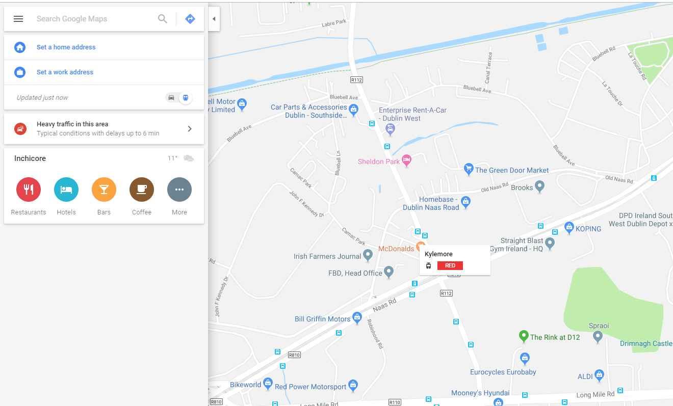
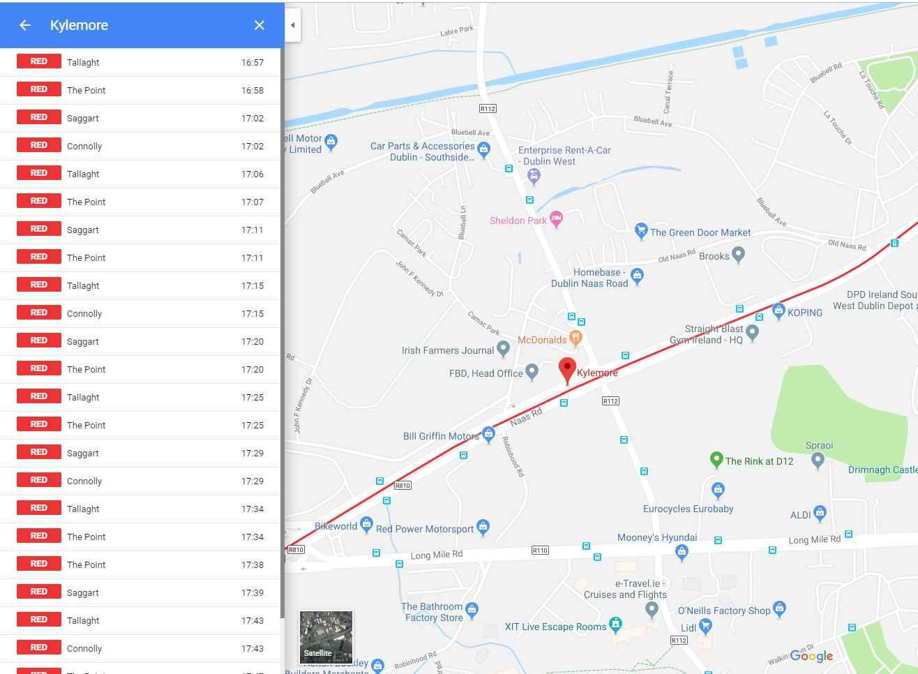
The following two stops are an inbound/outbound pair on a light rail line in Dublin:
stop_id,stop_name,stop_lat,stop_lon
"822GA00356","Kylemore","53.3265889562716","-6.34376337103717"
"822GA00357","Kylemore","53.3266344972522","-6.34380664554678"
Google maps represents these as one, the departure list in the attached image has both inbound and outbound trams: The 2 stops are located about 10m apart. I'm presuming google maps always uses GTFS and is using the stop file with the above extract. I'm wondering for the matching algorithm to work do stop names have to be exactly the same and be within a certain distance of each other ? Or is distance and name on its own enough ? Or is there an application where GTFS stops can be manually paired. Any light on this would be great ? Brian ?
If the pairing requires the name to be the same, then it is not ideal for other GTFS consuming applications that don't show paired stops in the same way. For these the stop names would be better represented as something like "Kylemore Inbound" and "Kylemore Outbound".
Combining stops like this also requires the combining of trips. It is as if a parent station stop is created on the fly with the 2 stops as children... could this be what the google algorithm does in a pre-processing step once it decides 2 stops are a pair ?
A
Reply all
Reply to author
Forward
0 new messages