Fwd: TROPICAL UPDATE TS ERIKA

Evans Mitchell
Evans Mitchell KD4EFM
sent from my HTC 4g LTE on Sprint.
From: "William D. Abernathy" <billyab...@polkfl.com>
Date: Aug 26, 2015 5:07 PM
Subject: TROPICAL UPDATE TS ERIKA
To: "William D. Abernathy" <billyab...@polkfl.com>
Cc:
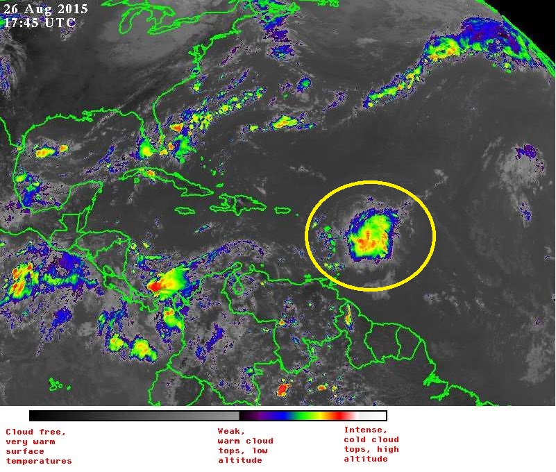
The center of Tropical Storm Erika was located near latitude 16.6 North, longitude 58.9 West. Erika is moving toward the west near 17 mph. A west-northwestward motion at a slightly slower forward speed is expected over the next 48 hours. On the forecast track, the center of Erika will move near or over portions of the Leeward Islands tonight, move near the Virgin Islands and Puerto Rico on Thursday, and be near or just north of the north coast of the Dominican Republic on Friday. Maximum sustained winds are near 45 mph with higher gusts. Little change in strength is forecast during the next 48 hours. Tropical storm force winds extend outward up to 105 miles primarily to the east of the center. The latest minimum central pressure estimated from data from a NOAA Hurricane Hunter aircraft is 1005 mb.
POLK COUNTY EMERGENCY MANAGEMENT EOC WILL CONTINUALLY MONITOR THE TROPICS AND WILL ADVISE OF CHANGES, IF NECESSARY
Billy Abernathy FPEM
Polk County Emergency Management
Emergency Operation Center EM01
1890 Jim Keene Blvd. Winter Haven Fla. 33880
O. 863-298-7001 C. 863-860-8002

Proudly serving since 1983
Like Us - facebook.com/polkcountyem
Follow us on Twitter @PolkEmergency
The “Extra Mile” has no traffic jams.
Evans F. Mitchell KD4EFM <GMail>
--
Evans F. Mitchell / KD4EFM
Field Service Tech.
Fisher Communications - Central Florida Division
C: 863-272-1713
O: 904-384-1270
Confidentiality Notice: "The information contained in this e-mail and all attachments is confidential and is intended only for the use of the person or entity to which it is addressed. If you are not the intended recipient, be aware that any review, disclosure, copying, distribution or use of this e-mail or any attachment is prohibited and may be unlawful. If you have received this e-mail in error, please contact the sender by return e-mail and delete the e-mail and all attachments from your system. Thank you."
From: William D. Abernathy [mailto:billyab...@polkfl.com]
Sent: Friday, August 28, 2015 10:54 AM
To: William D. Abernathy <billyab...@polkfl.com>
Subject: TROPICAL UPDATE TS ERIKA
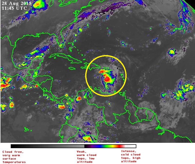
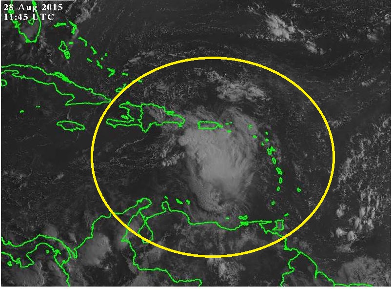
The center of Tropical Storm Erika was located near latitude 17.7 North, longitude 69.4 West. Erika is moving toward the west-northwest near 18 mph and this general motion is expected to continue for the next 48 hours. On the forecast track, the center of Erika will move over the Dominican Republic this afternoon, move near the Turks and Caicos Islands tonight, and move near the central and northwestern Bahamas Saturday and Saturday night. Reports from an Air Force Reserve Hurricane Hunter aircraft indicate that maximum sustained winds are near 50 mph with higher gusts. Some weakening is forecast this afternoon and tonight as Erika moves over land, followed by little change in strength through Saturday night. Tropical storm force winds extend outward up to 150 miles to the east of the center. Punta Cana at the eastern end of the Dominican Republic recently reported a wind gust of 40 mph. The minimum central pressure based on Hurricane Hunter aircraft data is 1008 mb
Evans F. Mitchell KD4EFM <GMail>
--
Evans F. Mitchell / KD4EFM
Field Service Tech.
Fisher Communications - Central Florida Division
C: 863-272-1713
O: 904-384-1270
Confidentiality Notice: "The information contained in this e-mail and all attachments is confidential and is intended only for the use of the person or entity to which it is addressed. If you are not the intended recipient, be aware that any review, disclosure, copying, distribution or use of this e-mail or any attachment is prohibited and may be unlawful. If you have received this e-mail in error, please contact the sender by return e-mail and delete the e-mail and all attachments from your system. Thank you."
From: William D. Abernathy [mailto:billyab...@polkfl.com]
Sent: Friday, August 28, 2015 4:59 PM
To: William D. Abernathy <billyab...@polkfl.com>
Subject: TROPICAL UPDATE TS ERIKA
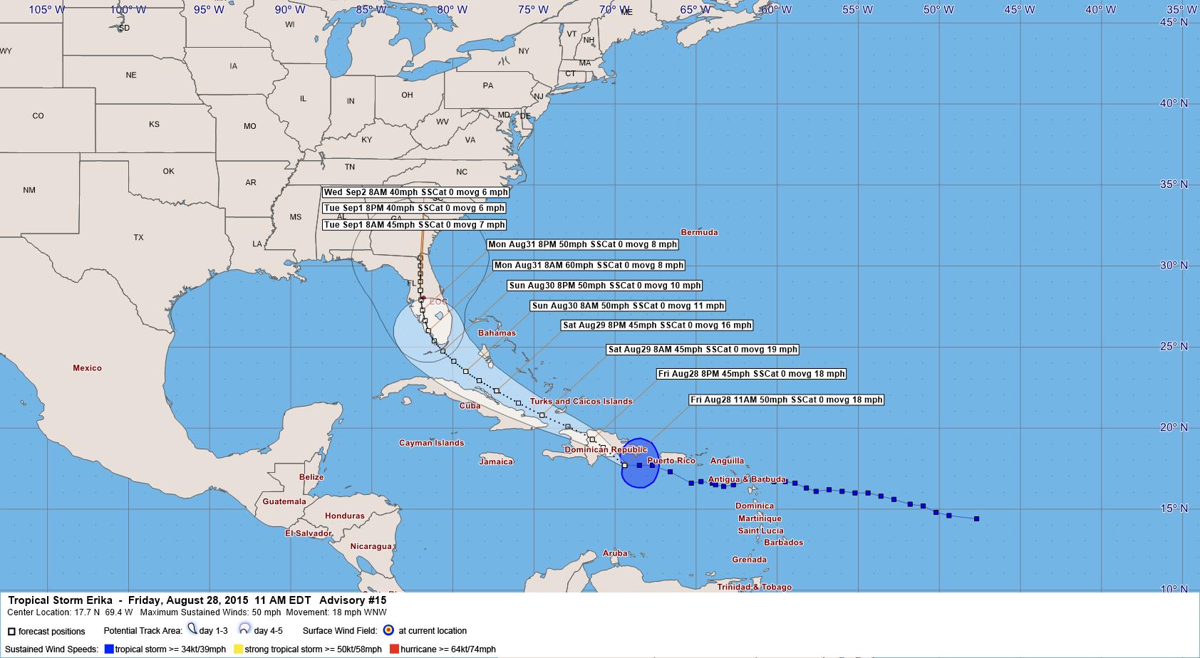
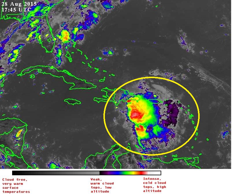
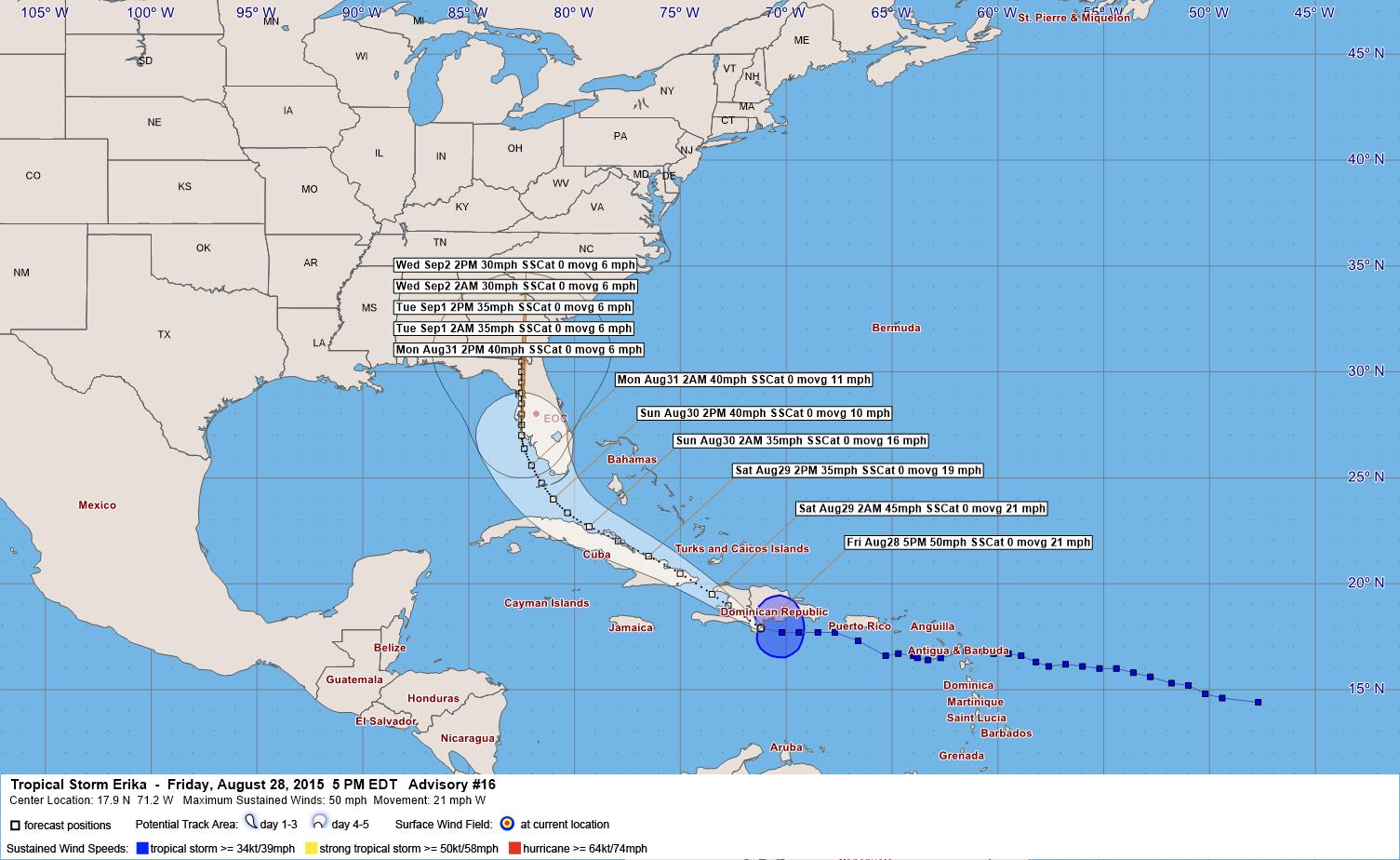
The center of Tropical Storm Erika was estimated near latitude 17.9 North, longitude 71.2 West. Erika is moving toward the west near 21 mph. A turn toward the west-northwest or northwest is expected tonight, with this motion continuing with a decrease in forward speed through Sunday. On the forecast track, the center of Erika will move over the Dominican Republic and Haiti during the next several hours, and be near the southeastern Bahamas or eastern Cuba on Saturday. Maximum sustained winds are near 50 mph with higher gusts. Weakening is forecast during the next 48 hours, and Erika is forecast to weaken to a tropical depression on Saturday. There is a possibility that Erika could dissipate to a trough of low pressure during or after its passage over Hispaniola. Tropical storm force winds extend outward up to 140 miles to the east of the center. Santo Domingo in the Dominican Republic recently reported a wind gust of 51 mph. The estimated minimum central pressure, based on observations from the Dominican Republic, is 1009 mb. Polk County Emergency Management EOC will be monitoring the progress of Tropical Storm Erika ….