Shelton Open Space Article

thomas harbinson

Teresa Gallagher
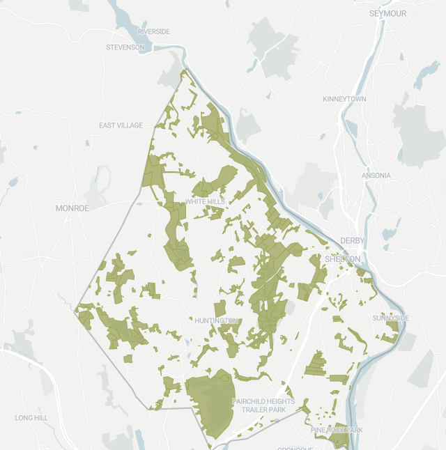
Paywall. Did they include a map in the online version? The print version does. They created it using GIS files I sent to Brian. They specifically requested shapefiles of the open space (the format used by GIS) so I sent them files for that layer. They turned off the PDR properties like Jones Farm, and made all the property types the same green, including Aquarion lands, Indian Well, Land Trust, City property. And they put that on their own base map of Shelton and were said to be really happy about getting the map info in that format.
From: shel...@googlegroups.com <shel...@googlegroups.com>
On Behalf Of thomas harbinson
Sent: Monday, March 28, 2022 10:34 AM
To: Unknown <shel...@googlegroups.com>
Subject: SheltonCC Shelton Open Space Article
|
CAUTION: This email originated from outside your organization. Exercise caution when opening attachments or on clicking links from unknown senders. |
--
You received this message because you are subscribed to the Google Groups "Shelton Conservation Commission" group.
To unsubscribe from this group and stop receiving emails from it, send an email to
sheltoncc+...@googlegroups.com.
To view this discussion on the web visit
https://groups.google.com/d/msgid/sheltoncc/CAG%2BbH5AVSH7pVeqP5aegC%2BF9n9AnmAFaBj2%2BXGoZNHU1hp1UWA%40mail.gmail.com.

Bill Dyer
To view this discussion on the web visit https://groups.google.com/d/msgid/sheltoncc/3883ef16562e46bd9677e58a3bb07e74%40mail.ex2013.local.
thomas harbinson
Photo: Mayor Mark Lauretti on the Riverwalk - creation of which was part of the first step in the redevelopment of Canal Street. The administration of Mayor Mark Lauretti, pictured on the Riverwalk, has purchased more than 1,000 acres of open space in the city in the last 30 years.
Shelton’s business boom drives open space land buys
March 27, 2022
Brian Gioiele / Hearst Connecticut Media
SHELTON — The city’s booming business sector and downtown redevelopment — in which private investors have invested hundreds of millions of dollars — rightly dominate the headlines.
But the city is more than just one giant expanding business sector, it is also home to thousands of acres of open — more than 1,000 of which has been purchased by the city over the last three decades to create a balance that city leaders say only makes Shelton that much more attractive.
“We’ve land-banked close to 2,000 acres in the last 30 years,” said Mayor Mark Lauretti. “We are creating flexibility for the city. This is why we do this.”
Since the mid-1990s, under Lauretti’s stewardship, the city has purchased more than 1,200 acres, according to data from the city’s Conservation Office, at a cost of more than $29 million.
“And it is all paid for,” Lauretti stated.
Shelton’s goal, as stated on the Conservation Commission website, is to preserve at least 15 percent of the land as permanently protected, locally-controlled open space — from city public open space properties to farmland protected by the purchase of development rights to Shelton Land Conservation Trust properties.
“Shelton continues to be served well by those who had forethought decades prior, to begin efforts to ensure that there would be land, both preserved and conserved, to benefit the community,” said Conservation Commission Chair Tom Harbinson said.
Harbinson said, in the early 1970s, there were not as many who saw the value in such planning efforts, mostly because there were still many open and undeveloped areas, but that was beginning to rapidly diminish.
An Open Space Plan was compiled and approved by the Planning & Zoning Commission and the Board of Aldermen. Harbinson said this open space road map outlined goals and concepts for how to achieve them.
“Working together, from both the planning perspective and the fiscal perspective, the benefits were seen by all parties, and the success we enjoy today came from that working together,” Harbinson said.
Permanently protected open space exists, but there are also lands that function as open space but are not permanently protected as such, Harbinson said.
“They all can provide wildlife habitats, and depending upon any funding to acquire them, opportunity for passive or active recreation,” he added.
Shelton presently owns some 2,000 acres of public open space, which are open to the public from dawn to dusk for passive recreational activities. Some areas also have ball fields and playgrounds.
Lauretti said the city has also moved to purchase conservation easements on farmlands totaling 411 acres — a move that protects these lands from future development.
The city has acquired agricultural conservation easements over several properties in the White Hills area, including Jones Family Farms (Homestead Acres, Pumpkinseed Hill, and Valley Farm), Shelton Family Farm, Beardsley Organic Farm; Stockmal Woods; and Little Knoll.
These easements, which stand at some 313 acres and cost the city $5.57 million, preclude housing developments but allow farming activities. The properties remain privately owned and are not normally open to the public except as advertised by the farmer.
“The city has been aggressive,” Conservation Officer Teresa Gallagher said of open space purchases.
The first purchase under Lauretti was the Eklund property, for $227,350 in 1995, followed in 1998 with some $6.5 million spent on seven parcels — the Mill Street “Gristmill Trail,” Traps Falls, Birchbank Mountain, Means Brook, two more Shelton Lakes sites, and Old Kings Highway at Mill Street.
Nicholdale Farm was purchased during Lauretti’s time, earlier than the Eklund land buy. Most of the money for the Nicholdale Farm purchase came from the city, but the land was deeded to the Land Trust.
Purchases continue to this day, with the acquisitions this past month of land on Pearmain Road — owned by the late Guy Beardsley — and 25 acres off Old Mill Road, known for its Christmas tree farm, owned by the Wells family.
The purpose of these purchases has been twofold, according to Gallaher — to extend greenway corridors such as Shelton Lakes, Means Brook and Farm Mill River, plus for wildlife habitats and trails; and also to aid in keeping widespread housing development in check.
“The city reserves the right to own the land and (and) use it for residents’ needs, whether it is recreation or just preserve it for greenway corridors for the environment,” Lauretti said, adding that in years past open space has been used for field space for sports teams and some 15 to 18 acres were used for the intermediate school complex.
“We want that balance,” Gallagher added.
Gallagher said another benefit to open space acquisition is reducing long term taxes. Keeping the number of housing developments in check, she said, helps reduce the demand for services and enrollment hikes in the schools.
brian....@hearstmediact.com
To view this discussion on the web visit https://groups.google.com/d/msgid/sheltoncc/CAH2OifWq-bXB%2B%2B4U1K%3DVPpm0LQfPfeiqaKtR3MPV38W%3Ds6bp8A%40mail.gmail.com.
Teresa Gallagher
Looks like the Mas property got included on their map. I had removed the “Transitory Open Space” items from the map I was exporting into shapefiles for the Herald, but I guess the data is still in there and they turned it on.
From: shel...@googlegroups.com <shel...@googlegroups.com>
On Behalf Of Bill Dyer
Sent: Monday, March 28, 2022 12:11 PM
To: shel...@googlegroups.com
Subject: Re: SheltonCC Shelton Open Space Article
|
CAUTION: This email originated from outside your organization. Exercise caution when opening attachments or on clicking links from unknown senders. |
Here is a copy of the map in the electronic version of the CT Post. Interestingly it includes the location of the Fairchild Heights Trailer Park?

To view this discussion on the web visit https://groups.google.com/d/msgid/sheltoncc/CAH2OifWq-bXB%2B%2B4U1K%3DVPpm0LQfPfeiqaKtR3MPV38W%3Ds6bp8A%40mail.gmail.com.

James W. Tate
Lets have a discussion on this article at our next CC meeting some are missing the point of Open Space purchase, and the balance.
Remember that open space acquisition was largely related to natural resource protection of the major watersheds in the City.
It would be interesting to look at the data in 10 yr. increments starting perhaps in 1970…. To see the growth of the grand list in comparison to open space funding/ purchase.
Balance? Also the added variables of school age children/ vs. 55+ . You may also look at the increase of City recreation/ community service, trails over the same period.
Remember the land area is finite but we seem to continue to develop our raw land… so to keep the balance we must actively be targeting the larger interconnected open spaces and not the developed corridors ???
If we don’t have accurate open space mapping by now we’re in trouble.

To view this discussion on the web visit https://groups.google.com/d/msgid/sheltoncc/CAG%2BbH5AsjAKQij3eZRCvbKY72wThKroo0xwb0i-b2iTQSkPu1Q%40mail.gmail.com.