Possibility to get dose rate from Safecast layer for a list of coordinates?
17 views
Skip to first unread message

Jan Helebrant
Apr 20, 2020, 9:37:59 AM4/20/20
to Safecast Discussion Group
Hi,
the current situation made me look again at some unfinished projects. One of them includes the basis for development of a QGIS plugin for radiation protection - possible topic for students but I did not manage to prepare the input data yet.
1) introduction
It is based on a real situation and real needs. Besides real time monitoring networks like pointcasts, official networks like EURDEP
or national ones like in Germany
or Czech Republic (Early Warning Network)
there are also networks using much cheaper integral measurements - in our case TLD dosimeters
placed in various locations. There are replaced with "new" ones from time to time and in case of some emergency it is planned to perform such replacement more often.
So you take a car, pick up all the dosimeters and take them in a lab to be analysed to get the dose values for each one.
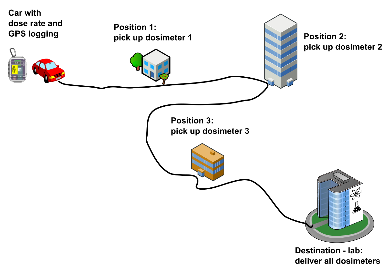
However you do not know how big was the part of the dose obtained during the transport - which may not be negligible for emergency situations and is different for each of the dosimeters:
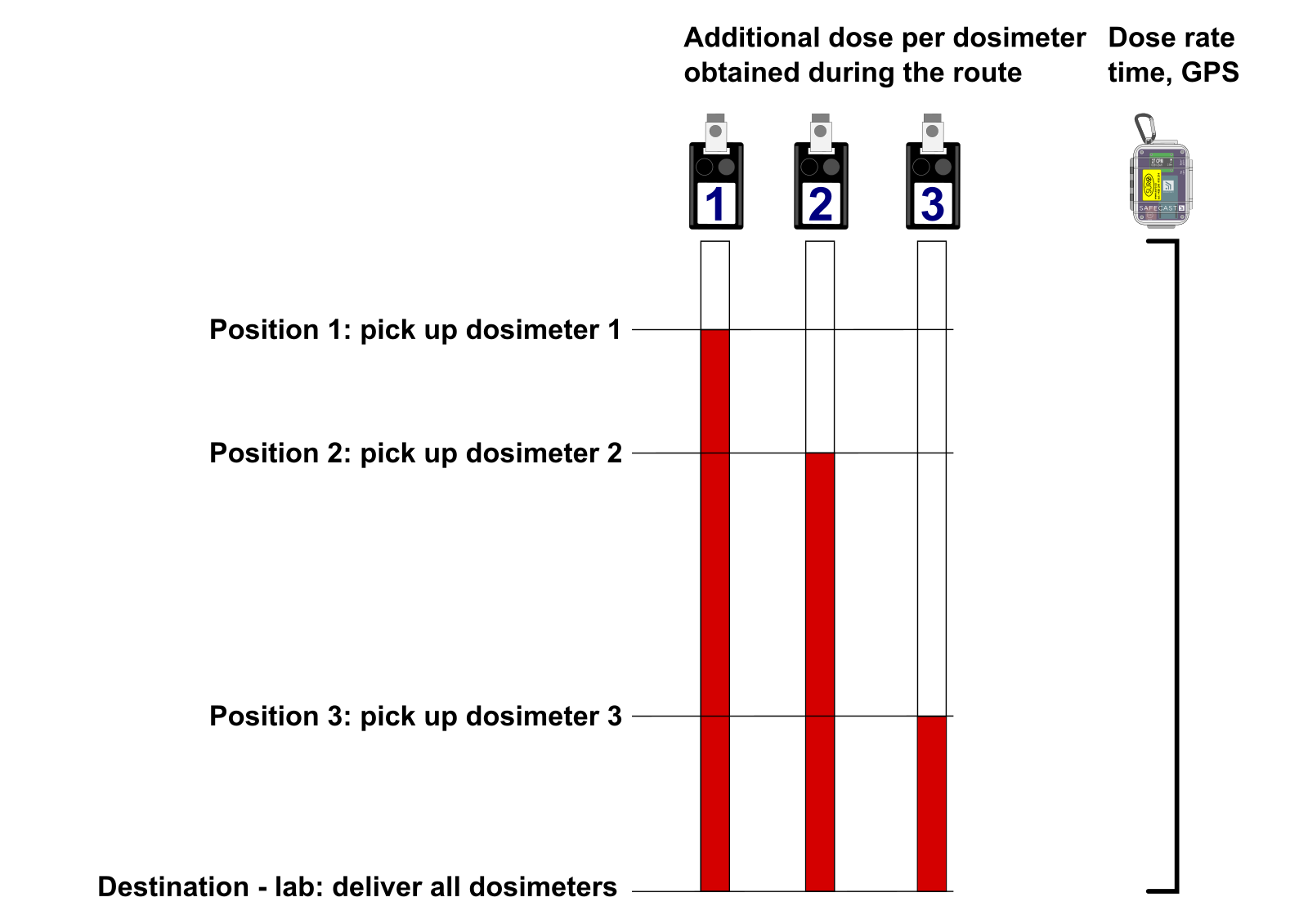
But, you can possibly calculate this in GIS (we prefer QGIS as it is free and you can easily deploy it everywhere) using input dataset of pickup positions and geotagged dose rate measurement (from bGeigie for example).
2) possible student project topic
the students already developed similar plugin for us:
so it is possible but we need some data to play with - no problem to prepare the pickup location dataset with some fictional locations but I need also the measurement data. I would like to use Safecast data from Fukushima region as it was a real situation and the dose calculations for particular routes will differ significantly - illustrative example for the students.
3) what I need?
I have a nice fictional scenario with car starting in Fukushima Daiichi NPP, picking up the dosimeters in several locations (placed in various Japan post offices) and delivering the dosimeters to JAEA - Tokai Research and Development Center, Nuclear Science Research Institute which might be a real destination for such task.
I have some fictional routes in GPX (e.g. a list of coordinates) and would like to add the Safecast values to them. Is it possible to somehow get the values for each coordinate similar way the Crosshair feature does in the Tile Map?
thanks
Jan
PS: it is one-time task in order to prepare few training "measurements" for potential plugin development

Mat Schaffer
Apr 20, 2020, 11:38:55 PM4/20/20
to safecas...@googlegroups.com
You can right click the map to query the api for a given location. Does that help?
--
--
** This is a public discussion mailing list, opinions expressed on this list belong to the individual only, and are not to be taken as official statements from Safecast.
http://groups.google.com/group/safecast-japan
http://safecast.org
---
You received this message because you are subscribed to the Google Groups "Safecast Discussion Group" group.
To unsubscribe from this group and stop receiving emails from it, send an email to safecast-japa...@googlegroups.com.
To view this discussion on the web visit https://groups.google.com/d/msgid/safecast-japan/8cca565e-aa39-46d0-b87e-8ea0f383a852%40googlegroups.com.
Jan Helebrant
Apr 21, 2020, 4:34:27 AM4/21/20
to Safecast Discussion Group
Not much,
Dne úterý 21. dubna 2020 5:38:55 UTC+2 Mat Schaffer napsal(a):
problem is not to get the data in the area of the route - I even have Safecast DB extract in QGIS but it is huuuge... despite the fact I filtered it to contain only limited time interval and only my area of interest...
Problem is that I would often have to put that fictional measurement from various LOGs (I do not think this is good idea and in some parts there are no point data) or use some sort of interpolation. I tried to perform some interpolation in SAGA GIS using my Safecast DB extracted data but it is not possible to handle it for the software.
I was thinking about interpolation in parts to reduce the computer load but being able to get nice resolution - something like tiles - and then I remembered that the Tile Map already has those interpolated tiles and that the Croshair feature is able to pick up the dose rate value for particular coordinate from it.
Jan
Dne úterý 21. dubna 2020 5:38:55 UTC+2 Mat Schaffer napsal(a):
You can right click the map to query the api for a given location. Does that help?
Mat Schaffer
Apr 23, 2020, 10:04:43 AM4/23/20
to safecas...@googlegroups.com
Ah, fair point. I'm not very familiar with the interpolation system but I believe the code is all in https://github.com/bidouilles/safemaps
-Mat
Looks like Nick even did a write up of it back in 2015 https://safecast.org/2015/01/rt-interpolation/
--
--
** This is a public discussion mailing list, opinions expressed on this list belong to the individual only, and are not to be taken as official statements from Safecast.
http://groups.google.com/group/safecast-japan
http://safecast.org
---
You received this message because you are subscribed to the Google Groups "Safecast Discussion Group" group.
To unsubscribe from this group and stop receiving emails from it, send an email to safecast-japa...@googlegroups.com.
To view this discussion on the web visit https://groups.google.com/d/msgid/safecast-japan/b0d60642-d50e-4e7d-a1b2-3a17beee9ffa%40googlegroups.com.
Reply all
Reply to author
Forward
0 new messages