ラスタ化(ベクタのラスタ化)について
4,023 views
Skip to first unread message

takesh ishmoto
Oct 13, 2016, 5:41:14 AM10/13/16
to QGIS初心者質問グループ
初級者ですよろしくお願いいたします。
DEMデータ(ベクタ:点データ)を、ラスタ化したいのですが
Pythonのエラーが発生しますなぜなのでしょうか。
よろしくお願いいたします。
~~~~~~~~~~~~~~~~~~~~~~~~~~~~~~~~~~~~
バージョンは現在の最新版です。
Visit http://download.qgis.org to get your copy of version 2.16.3
WIN8.1 64bit
Pythonのバージョンは2.1のようです。
~~~~~~~~~~~~~~~~~~~~~~~~~~~~~~~~~~~~~

DEMデータ(ベクタ:点データ)を、ラスタ化したいのですが
Pythonのエラーが発生しますなぜなのでしょうか。
よろしくお願いいたします。
~~~~~~~~~~~~~~~~~~~~~~~~~~~~~~~~~~~~
バージョンは現在の最新版です。
Visit http://download.qgis.org to get your copy of version 2.16.3
WIN8.1 64bit
Pythonのバージョンは2.1のようです。
~~~~~~~~~~~~~~~~~~~~~~~~~~~~~~~~~~~~~

fukuoka....@gmail.com
Oct 13, 2016, 9:01:05 AM10/13/16
to QGIS初心者質問グループ
こんばんは
私も初心者に毛の生えた程度なのですが、気になることが2点ほどあります。
1つ目は出力ラスタファイルが入力されていないことです。
選択ボタンをクリックして保存場所とファイル名を指定する必要があると思います。
2つ目ですが、パスやファイル名に2バイト文字(日本語)を使っているところです。
ラスタ化(ベクタのラスタ化)は使ったことは無いのですが、今まで経験したエラーの多くは2バイト文字
を使っていたことが原因でした。
お示しになった画像を見るとフォルダ名に日本語を使っているようですので、これが原因かもしれません。
直感での投稿ですが、解決のお役に立てれば幸いです。
私も初心者に毛の生えた程度なのですが、気になることが2点ほどあります。
1つ目は出力ラスタファイルが入力されていないことです。
選択ボタンをクリックして保存場所とファイル名を指定する必要があると思います。
2つ目ですが、パスやファイル名に2バイト文字(日本語)を使っているところです。
ラスタ化(ベクタのラスタ化)は使ったことは無いのですが、今まで経験したエラーの多くは2バイト文字
を使っていたことが原因でした。
お示しになった画像を見るとフォルダ名に日本語を使っているようですので、これが原因かもしれません。
直感での投稿ですが、解決のお役に立てれば幸いです。
takesh ishmoto
Oct 14, 2016, 2:21:03 AM10/14/16
to QGIS初心者質問グループ
回答ありがとうございました。
ラスタ化(ベクタのラスタ化)につきましては、ベクタファイル(DEM)からラスタを作製する機能かと思っていたのですが、そもそも違うようでした。
2バイトになるように変更したところうまくいきました。
ありがとうございました。
ご存知でしたら教えていただきたのですが、
ベクタファイル(DEM)から、ラスタファイルを作成するツールみたいなもの
ご存知でしたら教えていただけると幸いです。
(株式会社エコリスさんのツールみたいなものです)
fukuoka....@gmail.com
Oct 14, 2016, 6:27:12 AM10/14/16
to QGIS初心者質問グループ
こんばんは
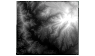
実験してみたら、ラスタ化(ベクタのラスタ化)でDEMを作成出来ました。
まず、基盤地図情報からダウンロードした標高データ(10mメッシュ)をShapeにしてQGISに読み込みました。
次にラスタ化(ベクタのラスタ化)ですが、10mメッシュは正確に10mでは無いので、ラスタ解像度を20mにしてみました。
この設定でラスタ化を行うと、DEMがきれいに出力されました。
解像度の設定でうまく行かなかったような気がしますが、いかがでしょうか?
実験してみたら、ラスタ化(ベクタのラスタ化)でDEMを作成出来ました。
まず、基盤地図情報からダウンロードした標高データ(10mメッシュ)をShapeにしてQGISに読み込みました。
次にラスタ化(ベクタのラスタ化)ですが、10mメッシュは正確に10mでは無いので、ラスタ解像度を20mにしてみました。
この設定でラスタ化を行うと、DEMがきれいに出力されました。
解像度の設定でうまく行かなかったような気がしますが、いかがでしょうか?


takesh ishmoto
Oct 14, 2016, 6:49:52 AM10/14/16
to QGIS初心者質問グループ
こんばんわ
返信ありがとうございます。
先ほど試した時は、ラスタ化のメニューが出てきていなかったのですが出てきました。
それで先ほど試したところ変換できました。
ご指摘の通り、解像度の設定に問題があるようです。
既存のサイズと解像度を保持するはうまくいきませんでしたが、
地図の単位ピクセルでの解像度で設定するとうまくいきました。
ありがとうございました。
>次にラスタ化(ベクタのラスタ化)ですが、10mメッシュは正確に10mでは無いので、ラスタ解像度を20mにしてみました。
ちなみに、DEMデータは、5mメッシュなので、解像度は10にするのがいいのでしょうか?
よろしくお願いいたします。

fukuoka....@gmail.com
Oct 14, 2016, 7:33:28 AM10/14/16
to QGIS初心者質問グループ
見通しがついたようで良かったです。
今回の作業内容にはあまり詳しくは無いのですが知っていることを追記します。
まず5mメッシュは緯度経度で0.2秒間隔、10mメッシュは0.4秒間隔のものだそうです。
実験では最初に解像度を10mにしたところ、縞々模様になってしまいました。
おそらく、標高データの入らないピクセルができでしまったためと予想しました。
そこで20mにしたところ、さきほどの投稿のようにうまくいきました。
質問は解像度は10mにすべきかということですが、10mでDEMはできると思います。
もう少し細かいDEMが必要な場合は、数値を変化させて試すのが良いかと?
あと、私の実験では平面直交座標を使っていましたので数値を20としましたが、緯度経度系でしたら
(1/3600)×0.4=0.000111111
となると思います。
Message has been deleted
takesh ishmoto
Oct 17, 2016, 1:07:25 AM10/17/16
to QGIS初心者質問グループ
解像度の件、大変参考になりました。
ありがとうございました。
Reply all
Reply to author
Forward
0 new messages