Is this a bug of pycoast 0.5.2?
46 views
Skip to first unread message

張伯誠
Dec 15, 2014, 10:56:39 PM12/15/14
to pyt...@googlegroups.com
Hello,
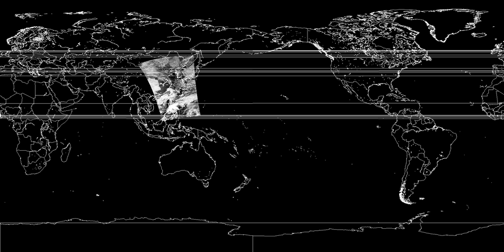
See the attached images, the area definition of lon_0_lat_0.png is:
REGION:equirectangular{
NAME:eqc
PCS_ID:eqc
PCS_DEF: proj=eqc, lat_0=0.0, lon_0=0.0
XSIZE:2048
YSIZE:1024
AREA_EXTENT:(-20037508.342789244,-10018754.171394622,20037508.342789244,10018754.171394622)
};
the other is lat_0=0.0, lon_0=180.0, the remaining is the same.
lon_0_lat_0.png is nice but lon_180_lat_0.png has many useless horizontal lines.
If you take a closer look at it, you would find that the lines come from the border of South Africa.
Is it a bug of pycoast 0.5.2?
I think pycoast does not handle such situation,
e.g., half continent is in the right side while the other part is in the left side.
Bocheng

Hróbjartur Þorsteinsson
Dec 16, 2014, 4:47:15 AM12/16/14
to pyt...@googlegroups.com
You are right.
Coastlines need a consistency check
that drawn line-segments do not exceed some sort
of threshold. We had considered that, but now
I think I should add that improvement.
Cheers,
Hrob.
Coastlines need a consistency check
that drawn line-segments do not exceed some sort
of threshold. We had considered that, but now
I think I should add that improvement.
Cheers,
Hrob.
--
You received this message because you are subscribed to the Google Groups "pytroll" group.
To unsubscribe from this group and stop receiving emails from it, send an email to pytroll+u...@googlegroups.com.
For more options, visit https://groups.google.com/d/optout.
You received this message because you are subscribed to the Google Groups "pytroll" group.
To unsubscribe from this group and stop receiving emails from it, send an email to pytroll+u...@googlegroups.com.
For more options, visit https://groups.google.com/d/optout.
Veðurstofa Íslands | Icelandic Met Office
Bústaðavegur 7-9, 150 Reykjavík
Sími +354 522 6000
www.vedur.is | en.vedur.is
E-mail Disclaimer
Bústaðavegur 7-9, 150 Reykjavík
Sími +354 522 6000
www.vedur.is | en.vedur.is
E-mail Disclaimer
Reply all
Reply to author
Forward
0 new messages