MTI1 FCI l1c test data problem
56 views
Skip to first unread message

lobsiger...@gmail.com
Aug 1, 2022, 7:28:20 AM8/1/22
to pytroll
Dear developers,
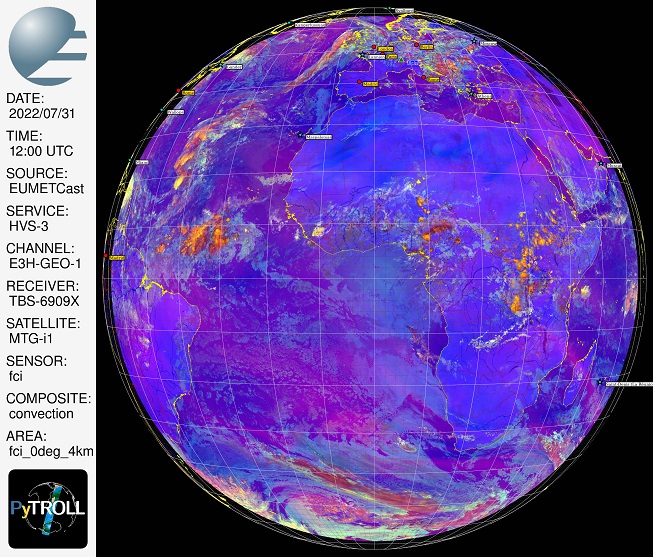
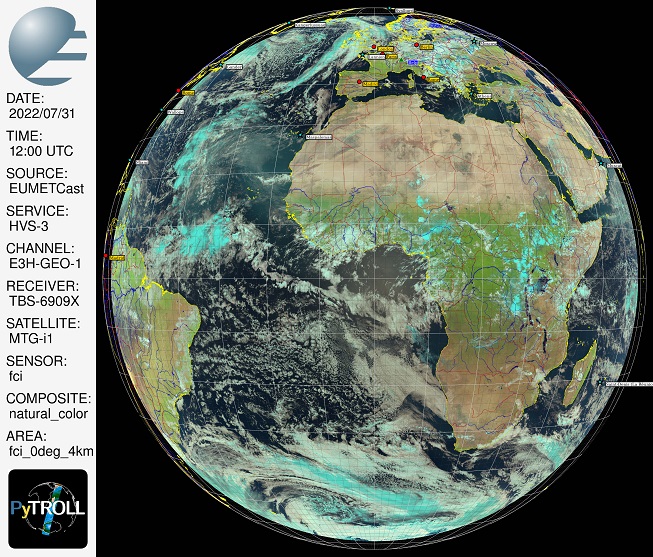
I downloaded 1 repeat cycle (RC0072, noon) of MTI1 FCI l1c data from:
I noted that many enhancement failed probably because solar angles
and the like are not yet available in the test data or cannot be
read by the current FCI reader. Nevertheless I could make a couple
of full disk composites that I resampled with area 'fci_0deg_4km':
While coastlines fit well the data does currently not seem to fully
fill the (GEOS) FCI area definition as distributed with SatPy 0.36.
My 'fci_0deg_4km' is the SatPy distributed 'fci_0deg_2km' where
I simply set the pixel sizes from (5568 x 5568) to (2784 x 2784).
What is the problem? Is this a FCI reader problem or are all pixels
in the test data towards the limb empty or maybe flagged unusable?
Best regards,
Ernst
P.S: reader='fci_l1c_nc' , three 20%x20% reduced size examples attached
I downloaded 1 repeat cycle (RC0072, noon) of MTI1 FCI l1c data from:
and the like are not yet available in the test data or cannot be
read by the current FCI reader. Nevertheless I could make a couple
of full disk composites that I resampled with area 'fci_0deg_4km':
https://we.tl/t-3MO8OF53DI wetransfer, link valid 1 week, 65MB
While coastlines fit well the data does currently not seem to fully
fill the (GEOS) FCI area definition as distributed with SatPy 0.36.
My 'fci_0deg_4km' is the SatPy distributed 'fci_0deg_2km' where
I simply set the pixel sizes from (5568 x 5568) to (2784 x 2784).
What is the problem? Is this a FCI reader problem or are all pixels
in the test data towards the limb empty or maybe flagged unusable?
Best regards,
Ernst
P.S: reader='fci_l1c_nc' , three 20%x20% reduced size examples attached
lobsiger...@gmail.com
Aug 4, 2022, 9:55:31 AM8/4/22
to pytroll
Hi again,
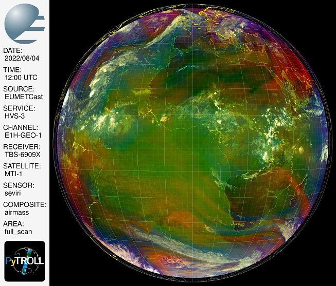
with the same MTI test data I made an area='full_scan' image which means in my script using resampler='native' resulting in a 5568x5568 pixel image.
When overlaying the grid and coastlines with Pycoast I see the same problem at the limb as before. Attached a reduced picture 10%x10% + legend at left.
Does this result again point to a problem in the EUMETSAT distibuted test data? Any easy possible tests I could still do to find out? Any other ideas?
Regards,
Ernst
lobsiger...@gmail.com
Aug 4, 2022, 1:45:47 PM8/4/22
to pytroll
It's me once more,
After finally reading this document
chapter "4.2.7 Missing Pixels at High Satellite Zenith Angles" explained it all. Sorry for not doing my homework. But at least I did RTFM before asking silly questions to OPS.
As I suspected before the missing pixels are flagged unusable <cite>
with “missing_warning” in the pixel quality variable. </cite>. So everything falls into place now :-).
Cheers,
Ernst

martin....@smhi.se
Aug 5, 2022, 3:22:58 AM8/5/22
to pyt...@googlegroups.com
Hi Ernst!
Sorry for not answering earlier, many of us are on holiday at the moment, and I myself have been quite busy.
But, yeah, as you found out this is a "feature" of the test dataset. Happy you got your answer already.
Best regards,
Martin
On 04/08/2022 19:45, "lobsiger...@gmail.com" <lobsiger...@gmail.com> wrote:
> It's me once more,
>
> After finally reading this document
>
> https://sftp.eumetsat.int/public/folder/UsCVknVOOkSyCdgpMimJNQ/User-Materials/Test-Data/MTG/MTG_FCI_L1C_SpectrallyRepresentative_TD-360_May2022/MTGTD-360%20Spectrally%20Representative%20FCI%20L1C%20Test%20Products%20-%20Package%20Description%20(1290888%20V1).pdf
>
> chapter "4.2.7Missing Pixels at High Satellite Zenith Angles" explained
> https://we.tl/t-3MO8OF53DI <https://we.tl/t-3MO8OF53DI>
> You received this message because you are subscribed to the Google
> Groups "pytroll" group.
> To unsubscribe from this group and stop receiving emails from it, send
> an email to pytroll+u...@googlegroups.com
> <mailto:pytroll+u...@googlegroups.com>.
> To view this discussion on the web, visit
> https://groups.google.com/d/msgid/pytroll/4624bdc1-ab71-44b6-9a32-4f5f38ed3c34n%40googlegroups.com
> <https://groups.google.com/d/msgid/pytroll/4624bdc1-ab71-44b6-9a32-4f5f38ed3c34n%40googlegroups.com?utm_medium=email&utm_source=footer>.
>
Sorry for not answering earlier, many of us are on holiday at the moment, and I myself have been quite busy.
But, yeah, as you found out this is a "feature" of the test dataset. Happy you got your answer already.
Best regards,
Martin
On 04/08/2022 19:45, "lobsiger...@gmail.com" <lobsiger...@gmail.com> wrote:
> It's me once more,
>
> After finally reading this document
>
> https://sftp.eumetsat.int/public/folder/UsCVknVOOkSyCdgpMimJNQ/User-Materials/Test-Data/MTG/MTG_FCI_L1C_SpectrallyRepresentative_TD-360_May2022/MTGTD-360%20Spectrally%20Representative%20FCI%20L1C%20Test%20Products%20-%20Package%20Description%20(1290888%20V1).pdf
>
> wetransfer, link valid 1 week, 65MB
>
> While coastlines fit well the data does currently not seem to fully
> fill the (GEOS) FCI area definition as distributed with SatPy 0.36.
> My 'fci_0deg_4km' is the SatPy distributed 'fci_0deg_2km' where
> I simply set the pixel sizes from (5568 x 5568) to (2784 x 2784).
>
> What is the problem? Is this a FCI reader problem or are all pixels
> in the test data towards the limb empty or maybe flagged unusable?
>
>
> Best regards,
> Ernst
>
> P.S: reader='fci_l1c_nc' , three 20%x20% reduced size examples
> attached
>
> --
>
> While coastlines fit well the data does currently not seem to fully
> fill the (GEOS) FCI area definition as distributed with SatPy 0.36.
> My 'fci_0deg_4km' is the SatPy distributed 'fci_0deg_2km' where
> I simply set the pixel sizes from (5568 x 5568) to (2784 x 2784).
>
> What is the problem? Is this a FCI reader problem or are all pixels
> in the test data towards the limb empty or maybe flagged unusable?
>
>
> Best regards,
> Ernst
>
> P.S: reader='fci_l1c_nc' , three 20%x20% reduced size examples
> attached
>
> You received this message because you are subscribed to the Google
> Groups "pytroll" group.
> To unsubscribe from this group and stop receiving emails from it, send
> an email to pytroll+u...@googlegroups.com
> <mailto:pytroll+u...@googlegroups.com>.
> To view this discussion on the web, visit
> https://groups.google.com/d/msgid/pytroll/4624bdc1-ab71-44b6-9a32-4f5f38ed3c34n%40googlegroups.com
> <https://groups.google.com/d/msgid/pytroll/4624bdc1-ab71-44b6-9a32-4f5f38ed3c34n%40googlegroups.com?utm_medium=email&utm_source=footer>.
>
lobsiger...@gmail.com
Aug 5, 2022, 3:44:17 AM8/5/22
to pytroll
Hi Martin,
this was my bad. Quite embarrassing as I often insist that people should RTFM. Another "feature", as I have suspected, is the reason for most enhancements not working:
<cite>
In particular, the following variables under the /state/celestial group are not currently computed
by the simulation code:
• solar_elevation
• solar_azimuth
• orbit_phase
• sun_eclipse_by_earth
• sun_eclipse_by_moon
Note that the solar_elevation and solar_azimuth variables are intended to describe the solar
angles in the instrument frame (as seen by the satellite), rather than for each pixel on the ground.
</cite>
Have a nice day,
Ernst
Reply all
Reply to author
Forward
0 new messages