Drone mapping
267 views
Skip to first unread message

Keir Vaughan-taylor
Dec 6, 2021, 3:42:18 PM12/6/21
to PTGui Support
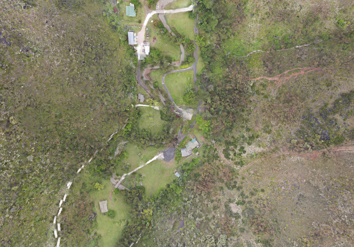
I use a Mavic Enterprise Dual Visual and Infrared drone to map terrains especially in Cavernous terrains.
It would be really good if PTGui camera databas included the Mavic amera in its database. For the record the visual camera has a sensor diameter of 8.2mm or 1/2.3 inch
- Sensor1/2.3" CMOS; Effective pixels: 12M
- LensFOV: approx. 85°
- 35 mm format equivalent:24 mmAperture: f/2.8
Focus: 0.5 m to ∞
I acknowledge with mapping Iiam pushing PTGui to extreme limits using 4k images and stitching about 500 images. PTGui uses my graphics card and is fast to produce a result.
Recognising that best results are from images take from a single location and minimises parallax my stitched images across a terrain are almost good enough. I also stitch and compare the visual and infrared images.
There are problems. the attached stitched image (scaled down 720x500) was created in very unsuitable conditions in a rugged terrain on a foggy morning. I will need to go back and do it again.
Even so notice the left hand road which is disjointed. I tried adding many control points but the problem persists. Does anyone have an idea what causes it and how this effect can be minimised

PTGui Support
Dec 7, 2021, 2:11:04 AM12/7/21
to pt...@googlegroups.com
Hi Keir,
I'm sorry but in general PTGui is unsuitable for creating aerial maps.
Stitching breaks completely as soon as there is any elevation. This is
due to parallax: once you fly to a different location, the perspective
changes. Images with parallax cannot be stitched perfectly. Mosaic
stitching only works if the subject is absolutely flat.
Kind regards,
Joost Nieuwenhuijse
www.ptgui.com
On 06/12/2021 21:42, Keir Vaughan-taylor wrote:
> I use a Mavic Enterprise Dual Visual and Infrared drone to map terrains
> especially in Cavernous terrains.
>
> It would be really good if PTGui camera databas included the Mavic amera
> in its database. For the record the visual camera has a sensor diameter
> of 8.2mm or 1/2.3 inch
>
> * Sensor1/2.3" CMOS; Effective pixels: 12M
> * LensFOV: approx. 85°
> *
> You received this message because you are subscribed to the Google
> Groups "PTGui Support" group.
> To unsubscribe from this group and stop receiving emails from it, send
> an email to ptgui+un...@googlegroups.com
> <mailto:ptgui+un...@googlegroups.com>.
> To view this discussion on the web visit
> https://groups.google.com/d/msgid/ptgui/98eb8cbc-e46e-4259-92a2-2f28c2c61a4bn%40googlegroups.com
> <https://groups.google.com/d/msgid/ptgui/98eb8cbc-e46e-4259-92a2-2f28c2c61a4bn%40googlegroups.com?utm_medium=email&utm_source=footer>.
I'm sorry but in general PTGui is unsuitable for creating aerial maps.
Stitching breaks completely as soon as there is any elevation. This is
due to parallax: once you fly to a different location, the perspective
changes. Images with parallax cannot be stitched perfectly. Mosaic
stitching only works if the subject is absolutely flat.
Kind regards,
Joost Nieuwenhuijse
www.ptgui.com
On 06/12/2021 21:42, Keir Vaughan-taylor wrote:
> I use a Mavic Enterprise Dual Visual and Infrared drone to map terrains
> especially in Cavernous terrains.
>
> It would be really good if PTGui camera databas included the Mavic amera
> in its database. For the record the visual camera has a sensor diameter
> of 8.2mm or 1/2.3 inch
>
> * LensFOV: approx. 85°
> *
> 35 mm format equivalent:24 mmAperture: f/2.8
> Focus: 0.5 m to ∞
>
> I acknowledge with mapping Iiam pushing PTGui to extreme limits using 4k
> images and stitching about 500 images. PTGui uses my graphics card and
> is fast to produce a result.
> Recognising that best results are from images take from a single
> location and minimises parallax my stitched images across a terrain are
> almost good enough. I also stitch and compare the visual and infrared
> images.
>
> There are problems. the attached stitched image (scaled down 720x500)
> was created in very unsuitable conditions in a rugged terrain on a foggy
> morning. I will need to go back and do it again.
> Even so notice the left hand road which is disjointed. I tried adding
> many control points but the problem persists. Does anyone have an idea
> what causes it and how this effect can be minimised
>
> --
> Focus: 0.5 m to ∞
>
> I acknowledge with mapping Iiam pushing PTGui to extreme limits using 4k
> images and stitching about 500 images. PTGui uses my graphics card and
> is fast to produce a result.
> Recognising that best results are from images take from a single
> location and minimises parallax my stitched images across a terrain are
> almost good enough. I also stitch and compare the visual and infrared
> images.
>
> There are problems. the attached stitched image (scaled down 720x500)
> was created in very unsuitable conditions in a rugged terrain on a foggy
> morning. I will need to go back and do it again.
> Even so notice the left hand road which is disjointed. I tried adding
> many control points but the problem persists. Does anyone have an idea
> what causes it and how this effect can be minimised
>
> You received this message because you are subscribed to the Google
> Groups "PTGui Support" group.
> To unsubscribe from this group and stop receiving emails from it, send
> an email to ptgui+un...@googlegroups.com
> <mailto:ptgui+un...@googlegroups.com>.
> To view this discussion on the web visit
> https://groups.google.com/d/msgid/ptgui/98eb8cbc-e46e-4259-92a2-2f28c2c61a4bn%40googlegroups.com
> <https://groups.google.com/d/msgid/ptgui/98eb8cbc-e46e-4259-92a2-2f28c2c61a4bn%40googlegroups.com?utm_medium=email&utm_source=footer>.

Kelly
Dec 7, 2021, 7:25:11 AM12/7/21
to PTGui Support
I've been and will forever remain a great fan of PTGui Pro for many years and as a land surveyor, I've also tried in vain to use it on UAV acquired imagery. It's an exercise in futility, one of those things that you learn from. The best advice I can offer is to use photogrammetry software that's intended for aerial images. The program that I use is made by Blue Marble Geographics called Global Mapper Pro. Using one of its many tools, Pixels to Points (P2P), you can achieve seamless ortho images, 3-d terrain models, meshes, etc. which uses structure-from-motion or SfM for its photogrammetry processing which is not the same as classical aerotriangulation adjustment. It's way cheaper than Pix4D, however it still is a serious investment at about $1350 USD, but there's way, way more to GM than P2P. You don't have to be a surveyor and you don't have to establish ground control points as long as you don't require highly accurate maps tied to a known spatial reference system.
Keir Vaughan-taylor
Jan 12, 2022, 4:54:05 PM1/12/22
to pt...@googlegroups.com
Thank you for your considered reply. Although PTGui Support says that PTGui is unsuitable for aerial applications the results I am getting are pretty good. I will try taking the drone higher which will reduce parallax and reduce the number of images to cover an area.
I took a look at Global Mapper Pro which looks amazing (the lidar processing looks very interesting) but this software is too expensive with more features than I am going to have time for. Also I am a Linux specialist whereas Global Mapper Pro is Windows based. PTGui sings with the Linux operating system.
As an aside, there seems to be a bug in the PTGui lens entry. When I try to set the various parameters for the Mavic lenses the system the system keeps changing sensor size HOV and so on to something the system thinks it should be. In the end I just set the sensor size and that seemed to work.
--
You received this message because you are subscribed to the Google Groups "PTGui Support" group.
To unsubscribe from this group and stop receiving emails from it, send an email to ptgui+un...@googlegroups.com.
To view this discussion on the web visit https://groups.google.com/d/msgid/ptgui/867866e6-a7d4-4825-a53a-7c97e6eec1ccn%40googlegroups.com.

FlyoverG
Feb 11, 2022, 2:13:11 PM2/11/22
to PTGui Support
Kelly--- really was glad to see this reply of yours. I have a question or 2, about your experience in drone mapping and particularly your use of Global Mapper. About 5 years ago I got great ortho-mapping results with Agisoft Photoscan but since then upgraded to Agisoft Metascan and have yet to produce decent results with very similar photo-sets (about 200 photos or less). I used Global Mapper for processing topo maps years ago and loved it. Am considering a new license but was wondering about how long it takes in your workflow you to produce a decent GeoTiff or the like with say about 150 to 300 photos (with heavy overlapping in most cases). Metascan takes hours and I have to jack with 3D point-clouds and things I do not need. ptGui rocked on the first 2 or 3 sets of images I tried (though these were relatively flat areas). I'd hoped I could convert the big 24,000x24000 pixel jpgs to Geotiffs, then georectify with QGIS or the like, but it sounds like ptgui might choke on hilly areas. Anyway, would appreciate anything you might add about the speed of a Global Mapper stitching operation. Thanks!
Kelly
Feb 11, 2022, 2:44:47 PM2/11/22
to PTGui Support
As I'm currently beta testing GM v23.1, and if you like, I could time how long it takes for a test dataset to process using my 6-year old system. Send a private email with the link to the zipped up dataset of your test images which must contain geographic coordinates in each image. Global Mapper cannot process images without geospatial data, unlike Photoscan.
Reply all
Reply to author
Forward
0 new messages