Geospatial data from Network Rail
1,182 views
Skip to first unread message

Peter Hicks
Jun 16, 2022, 5:52:50 AM6/16/22
to A gathering place for the Open Rail Data community
All,
I made a request to Network Rail to release some sets of geospatial data under FOI/EIR. I'm pleased to say they've responded with the data, published under the Open Government Licence (OGL).
To make it easier to re-use, I've uploaded the data - without any changes to the shapefiles - at https://github.com/openraildata/network-rail-gis
Please comment on this thread if you find the data useful.
Peter

Matt Carlson
Jun 17, 2022, 9:37:45 AM6/17/22
to A gathering place for the Open Rail Data community
Hello Peter,
This dataset looks good! Geographically, it looks very rich - but does anyone know whether there is a linkage between the various fields to TIPLOCs for instance?
Thanks for posting this,
Matt
Peter Hicks
Jun 17, 2022, 9:57:02 AM6/17/22
to openrail...@googlegroups.com
HI Matt
This is just a representation of the physical layout - the train planning domain isn't mapped on to it.
Various bits of data exist which list the latitude/longitude of TIPLOCs, but I am not aware of any official source, nor am I aware of any unofficial source which does not have restrictions or caveats on reuse (e.g. attribution, non-commercial only).
Peter
--
You received this message because you are subscribed to the Google Groups "A gathering place for the Open Rail Data community" group.
To unsubscribe from this group and stop receiving emails from it, send an email to openraildata-t...@googlegroups.com.
To view this discussion on the web, visit https://groups.google.com/d/msgid/openraildata-talk/af54d4cd-8a8f-4708-ade9-01f98049d3dcn%40googlegroups.com.

Mike F (Hastings Line)
Jul 23, 2022, 5:36:23 AM7/23/22
to A gathering place for the Open Rail Data community
Wow, this is really useful - I just published an app for travel on the Hastings Line with map data and ended up tracing and encoding the rail route by hand
Mike (hastingsline.travel)

Legolash2o
Jul 27, 2022, 11:55:11 AM7/27/22
to A gathering place for the Open Rail Data community
The geospatial data is great as you can do things like this:
https://railmap.azurewebsites.net/Public/Route?origin=CHRX&via1=WLOE&via2=EWERSTJ&via3=LNDNBDE&via4=BLUANCR&via5=NWCROSS&via6=NWCRTHJ&via7=PKBGJN&via8=HTHRGRN&via9=GRVPK&via10=CHSLHRS&via11=PETSWDJ&via12=ORPNGTN&via13=SVNOAKS&via14=TONBDG&via15=SMHLTUN&via16=HBROOMS&via17=TUNWTJN&via18=TUNWELL&via19=STWHTNL&via20=FRANT&via21=WADHRST&via22=WADHTLS&via23=SNGT&via24=ETCHNGM&via25=RBRTSBD&via26=MNTFLDT&via27=BATTLE&via28=CRWHRST&via29=WSLE&via30=BOPEEPJ&via31=STLNRWS&destination=HASTING
https://railmap.azurewebsites.net/Public/Route?origin=CHRX&via1=WLOE&via2=EWERSTJ&via3=LNDNBDE&via4=BLUANCR&via5=NWCROSS&via6=NWCRTHJ&via7=PKBGJN&via8=HTHRGRN&via9=GRVPK&via10=CHSLHRS&via11=PETSWDJ&via12=ORPNGTN&via13=SVNOAKS&via14=TONBDG&via15=SMHLTUN&via16=HBROOMS&via17=TUNWTJN&via18=TUNWELL&via19=STWHTNL&via20=FRANT&via21=WADHRST&via22=WADHTLS&via23=SNGT&via24=ETCHNGM&via25=RBRTSBD&via26=MNTFLDT&via27=BATTLE&via28=CRWHRST&via29=WSLE&via30=BOPEEPJ&via31=STLNRWS&destination=HASTING

Adrian Hicks
Oct 25, 2022, 6:37:56 AM10/25/22
to A gathering place for the Open Rail Data community
This looks amazing. I’ve been searching for weeks for geospatial data for the UK rail network. Until now I’ve been forced to use Overpass-turbo and OSM to try and pull data that I’ve then had to parse through GPSVisualizer. It has been a massive faff and has resulted in many hours of manual labour.
Could someone tell me how would I start trying to use this data? My python is infant level.
A little background in what I’m trying to do and the data I would normally work with. I’m trying to create motion graphics with geospatial correct data. This is integrated to map tiles pulled from various servers. This is all used in Adobe’s After Effects using a plugin called Geolayers3. Normally I’d use a GPX file or if available JSON data, for a route.
This dataset seems to be just the ticket [sorry]
But understanding how to utilise it is my hurdle.
And and all info very gratefully received.
Cheers
Adrian

Luke Scott
Nov 26, 2022, 2:24:32 AM11/26/22
to A gathering place for the Open Rail Data community
Hi,
Im a student looking to use some of this data for some climate change analysis based around the uk rail network, this seems like the perfect thing for me but i fall down on knowing how to access the data.
Could anyone provide a guide/point me in the direction of some instructions as to how this data can be visualised on a map?
any help would be much appreciated.
Luke.
Adrian Hicks
Nov 26, 2022, 6:39:11 AM11/26/22
to A gathering place for the Open Rail Data community
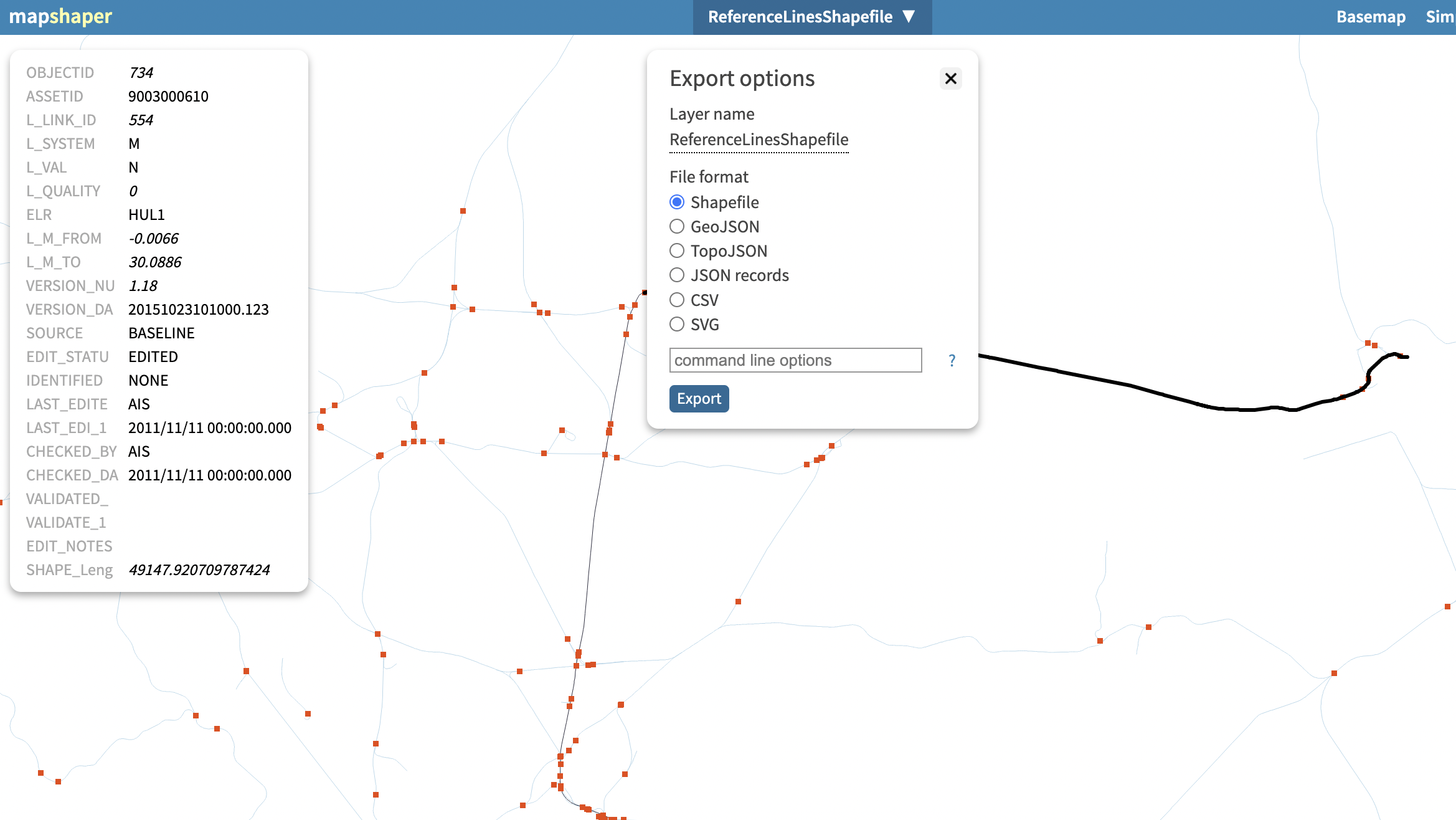
I've discovered a site called https://mapshaper.org/ this allows you to import the data from github and then you can even select the features of interest and export only those.
Seems to be very lightweight and handy.
I've created the start of a project which you can see here;
https://1drv.ms/v/s!Ap5IR9dQ9eMPgdohmp1MRZH5BP_zRQ?e=HOz7Vq
Seems to be very lightweight and handy.
I've created the start of a project which you can see here;
https://1drv.ms/v/s!Ap5IR9dQ9eMPgdohmp1MRZH5BP_zRQ?e=HOz7Vq
Luke Scott
Nov 26, 2022, 6:55:44 AM11/26/22
to openrail...@googlegroups.com
Cool I will have to check that out as well, thanks for the update!
You received this message because you are subscribed to a topic in the Google Groups "A gathering place for the Open Rail Data community" group.
To unsubscribe from this topic, visit https://groups.google.com/d/topic/openraildata-talk/_2FPq3rcFU8/unsubscribe.
To unsubscribe from this group and all its topics, send an email to openraildata-t...@googlegroups.com.
To view this discussion on the web, visit https://groups.google.com/d/msgid/openraildata-talk/5b79186c-f8a6-43b1-bccf-00e031b5f3efn%40googlegroups.com.
Peter Hicks
Mar 17, 2023, 3:05:05 PM3/17/23
to A gathering place for the Open Rail Data community
All,
This data has now been updated to March 2023 and is at https://github.com/openraildata/network-rail-gis/releases/tag/20230317-01
Peter

Ajay Gupta
Mar 26, 2023, 5:51:51 AM3/26/23
to A gathering place for the Open Rail Data community
Hello all,
This data set and the tool/app in the link https://railmap.azurewebsites.net/ is extremely useful! Thank you for sharing this.
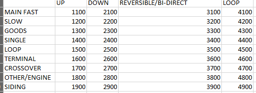
Could someone help me understand if there exists an identifier variable that assigns a up or down direction to each network link?
If not, can it be inferred from the other attributes?
Thank you,
Ajay
Legolash2o
Mar 26, 2023, 3:33:26 PM3/26/23
to A gathering place for the Open Rail Data community
There should be a TRID value which indicates the direction and type of track.
Ajay Gupta
Apr 2, 2023, 2:11:31 PM4/2/23
to A gathering place for the Open Rail Data community
Thank you so much Legolash2o!
This is exactly what I was looking for.
Reply all
Reply to author
Forward
0 new messages