Dear fellow adventure aficionados, We are conducting the beautiful Rupin pass trek in October this year. Please do go through the detailed program in our events page. This autumnal odyssey is guaranteed to be a memorable experience.
13 views
Skip to first unread message

Snowleopard
Aug 17, 2012, 3:28:59 AM8/17/12
to mystichima...@googlegroups.com
THE MYSTIC HIMALAYAN TRAILS RUPIN PASS TREK (OCT. 2012)
(An exiting and adventurous trek, which crosses over from Uttranchal to Kinnaur witnessing the onset of the beautiful Himalayan Autumn.)
This trek begins in the Garhwal Himalayas and takes you through some of the remotest Himalayan villages and culminates fittingly in lush green valley of Sangla in Himachal Pradesh. On crossing this pass you will witness the change in culture- from Hinduism of the Garhwal to a mix of Hinduism and Budhism in the Sangla valley. From the Rupin Pass at an altitude of 15,225 Ft. one can view the awesome Kinner Kailash range at close quarters.
The trek to the pass meanders along the Rupin River through picturesque villages and into the evergreen Deodar forests. The descent from the pass is equally spectacular with the view of both –the verdant Sangla Valley and the Baspa River. This trek is the perfect amalgamation of the landscapes of Garhwal & Kinnaur and perfect for trekkers seeking a somewhat ‘off the beaten path’ kind of experience.
TREK ITINERARY:
Day01- Pick up from Dehradun railway station.
Whole day drive through Mussoorie, Yamuna Pul, Nowgaon, Damta, Purola, Mori and Naitwar. The 11 km stretch to Dhaula from Naitwar is through the most enchanting forest that you will ever drive through. Night stay at Dhaula camp.
Day02- Daula 5,500 ft to Sewa 6,300 ft 7 kms. 6 hrs.
Level: Long climbs with short gentle walks in between.
Altitude gain: 360 mts/1180 ft. 11 kms).
Trek starts at Dhaula, a sleepy hamlet consisting of only a dozen or so homes and the last road head of Uttarakhand. Take the trail that starts at the village and heads up the valley to Sewa village. After crossing the sewa village, descend to Rupin river. Sewa is the last village of Uttrakhand. Overnight stay at bank of the Rupin river.
Day03- Sewa 6,300 ft to Jhaka 8,700 ft. 9 kms. 6½ hrs . Via Jiskun 7,600 ft.
Level: Long climbs with short gentle walks in between. Altitude gain: 730 mts/2394 ft. 9 kms)
The trail goes to Gosangu village and follows the Himanchal govt. road. The trek starts gradually and builds up into a steep ascent to Jiskun. Jiskun sits high above the confluence of Nargani and Rupin and is a village in two parts – upper and lower Jiskun. Lower Jiskun which is now called Bawta, is 3½ km ahead of Jakha, the highest and the last village on the Rupin pass trek.
The trail out of Jiskun descends rapidly through a forest of deodars and walnut until it reaches an enchanting dark fold in the mountain. We descend only to start climbing again finally reaching Jakha (the highest village in the valley)! Know that the day will be tiring and enjoy the beautiful scenery and the people. Overnight stay in the village.
Day04- Jhaka 8,700 ft to Saruwas thatch 11,150 ft. 6 kms. 5½ hrs.
Level: Mostly climbs with one gentle walk in between.
Altitude gain: 650 mts/2132 ft. 6 kms).
Trek through Pine and Maple forest and then descend to walk along the banks of the Rupin River. The well defined trail ascends past the playground, passing through fields of the upper Jakha village before entering a magnificent Fir forest. The entry to the forest is, again, so sudden that it is almost like someone has opened up a gate to let you in. The towering blue Pines, each more than few centuries old, takes you through a terrain that is pristine and untouched. Overnight stay in Camp.
Day05- Saruwas thatch 11,150 ft to Dhanderas thatch 11,680 ft (lower water fall camp) 5 kms. 4½ hrs.
Level: Initial short climb followed by easy undulating walks.
Altitude gain: 210 mts/680 ft. 6 kms)
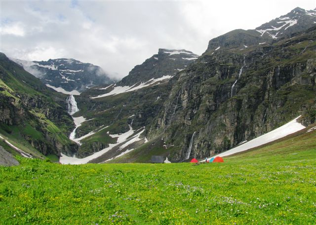
The valley is a picture of serenity, with the waterfall at its center and wildflowers all around. The climb through the forests and shrubs makes leads the way to a grand amphitheater of greenery. You stand on the edge and enjoy front row seats of a grand scale production. As you peer from the lip of the U-Shaped valley you notice thousands of waterfalls cascading down its brown walls to meet the Rupin. In contrast, laid out in front of you are miles of green meadows, dotted with thousands of yellow marigold. The undulating meadows the Rupin gracefully snakes its way up to its waterfall source. And, as an icing on the cake, you have white snow patches lying scattered all along on the edges of the meadows. Overnight stay in camp.
Day06 - Dhanderas thatch 11,680 ft to Upper Waterfall camp13,120 ft. 2 kms. 3hrs.
Level: Steep climb. (2 hrs steep climb.
Altitude gain: 210 mts/1444 ft.)
It is a short but a steep ascent towards the rocky cliffs before reaching the flower covered meadows at the top. The snow patch at the base of the waterfall can be quite challenging. Avoiding the snow patch directly, we climb on its boulder strewn hill side until we come to the trail that cuts across the snow patch. It would make sense to have a stick or trekking pole for support. An ice-axe is extremely helpful here. Overnight stay at camp.
Day07 - Upper Waterfall 13,120 ft to Rupin Pass 15,250 ft to Ronti Gad 13,420 ft. 10 kms. 11 hrs.
Level: Steep climb initially, followed by a gradual ascending trail. Short sharp climb to the pass, followed by a steep descent.
This is most important and longest day of the itinerary. The trail to Rati Pheri starts out to the left of the meadow, climbing steeply along a snowpatch that looks a mile long. The climb gains altitude. An hour into the climb, the ascent veers left rounding the shoulder of a ridge and opens out to the camping grounds of Rati Pheri. Stop here for a breather and much needed drink of water (and also fill your bottles for water source is limited until you cross the pass). Also, marvel at the change in scenery.
The Rupin valley that has been your companion for the last six days is lost to view, and the alpine Dhauladar range takes its place to your right and across the valley. It is now snow fields and alpine country till you get to the Rupin pass. This is a good time to put on your gaiters if you are carrying them. Trek takes us up to the pass where we will have unobstructed view of the entire Kinnaur Kailash Range, here we will spend some time taking it all in. There is a sharp descent to the endless meadows that stretch all the way to Sangla Kanda. At the base of the descent there is a stream alongside which we pitch camp. Old remnants of camping fire are another way to recognize the camping ground – otherwise indistinguishable from the surrounding. This is the camping grounds of Ronti Gad – another green paradise on earth.
Day08- Ronti Gad 13,420 ft to Sangla 8,800 ft. 12 kms. 6½ hrs.Level: Gradual to steep descent.
Trek winds down from the fields of Sangla kanda through a forest of Oak, Deodar ,Pine and blue Pine. Across the Baspa River, Shangla appears almost out of nowhere giving you a bit of a start, as the nature journey ends and you start walking through a bazaar! Sangla is a small village, surrounded by high mountains & well known for trout fishing. The Kinnar Kailash mountain range towers over the Sangla valley. (Overnight in a guesthouse)
Day09- Sangla to Shimla . Night travel to Delhi.260km., 7-8 hrs. drive.
We drive down to Shimla and reach by evening to take the overnight bus or a flight to NewDelhi. One can also take a train from Kalka.
TREK ENDS. BON VOYAGE.
SERVICES INCLUDED / EXCLUDED IN THE TRIP COSTS:
COST INCLUSIONS:
The trek package includes the following services,
• The services of an educated Mystic Himalayan Trails representative or escort / guide, well versed with native flora/fauna, topography & culture during the entire trek program.
• During the trek, all camping logistics and mules / porters/ to carry luggage. Participants will be required to carry only their day sacks with their daily essentials etc.
• Camping on twin sharing basis in 2-man tents, with foam mattresses, sleeping bags and kitchen tent, toilet tent etc.
• One Cook and camp helper with all necessary kitchen items, utensils etc.
• All transportation as per the itinerary, inclusive of transfers to the roadhead before the trek and transfer from the roadhead to Shimla (Your hotel), after the conclusion of the trek.
• Boiled drinking water during the trek and warm water for personal ablutions in the morning.
• All meals during the trek program.
• Wildlife / environmental Permits and Levies, wherever required.
• All camping charges.
• Trek Briefing / debriefing & guides charges.
• Charges for following the global ‘Leave No Trace’ protocol.
• Insurance of the trekking staff
• Good medical / first aid kit.
COST EXCLUSIONS:
The tour package excludes the following,
• Any accidental, travel or medical insurance. It is advisable for the participants to get themselves comprehensively insured before the tour.
• Any expenses of a personal nature.
• Any and all evacuation charges (medical or otherwise), or hospitalisation or physicians consultation charges. Your own insurance policy should also, ideally, cover this.
• Accommodation or meals in any hotel in Shimla, before the commencement of the trek or after its conclusion In Sangla (can be arranged by us if desired).
• Any air (or surface) transfers or airfare between Delhi and Dehradun or vice versa Shimla and Delhi
• Beverages or drinks of any sort, including soft drinks, alcoholic / non-alcoholic drinks or bottled / mineral water.
• Tipping of the drivers or guides etc.
• Any photography or camera charges or batteries.
• Any shopping charges or transfers for personal visits to the market etc.
• Any other services not specifically mentioned in the service inclusions.
ADDITIONAL INFO.
On How to Reach:
By Air:- Jolly Grant Airport is the airport serving Dehradun, located about 25 km from the city. There is a daily flight from Delhi for Dehradun
By Train:-An excellent rail network connects Dehradun to other important cities like Delhi, Mussoorie, Mumbai, Varanasi, Lucknow, and Kolkata.
From Delhi- DDN NZM AC EXPRESS (2205)
By Road : - By road, Dehradun is well connected with major destinations of the country. NH72 connects Dehradun to Nahan (95 km) to the north-west, and thereon to Panchkula, Chandi¬garh and Shimla. NH 72 terminates at Haridwar, which is at 54km from Dehradun. Dehradun is located at a distance of 235 km from Delhi. NH72A links Dehra Dun to NH58 at Roorkee (67 km) and thereon south to Meerut (170 km) and Delhi (235 km). There is regular bus service from Delhi for Dehradun from Delhi’s ISBT Kashmere Gate.
Dear friends, in case you are intrested in joining this program and need further information / clarifications. It shall be our pleasure to provide the same. Kindly do get in touch with us by sending us a mail at: rahu...@gmail.com / mystichima...@gmail.com
Or call us on ++ 91 9816084461 / ++ 91 1902 251274
Assuring you of our superlative service benchmarks & with the warmest regards,
THE MYSTIC HIMALAYAN TRAILS TEAM.
Reply all
Reply to author
Forward
0 new messages