get direction from insert coordinate to current location
213 views
Skip to first unread message

fadlin...@gmail.com
Dec 14, 2013, 12:49:20 PM12/14/13
to mitappinv...@googlegroups.com
hello, i have done create app name WHERE MY CAR.. I CURRENTLY want to create app that give direction from inserted long,latitute to my current position.. can someone help me out.. i really2 have no idea how to build it

Hal Abelson
Dec 14, 2013, 2:03:57 PM12/14/13
to mitappinv...@googlegroups.com, fadlin...@gmail.com
You can use the location sensor to get your current latitude and longitude. Knowing that, and also the latitude and longitude of the car, you can compute the direction. You'll need to do some math
fadlin...@gmail.com
Dec 14, 2013, 2:09:21 PM12/14/13
to mitappinv...@googlegroups.com, fadlin...@gmail.com
On Saturday, 14 December 2013 11:03:57 UTC-8, Hal Abelson wrote:
> You can use the location sensor to get your current latitude and longitude. Knowing that, and also the latitude and longitude of the car, you can compute the direction. You'll need to do some math
>
>
>
> On Saturday, December 14, 2013 12:49:20 PM UTC-5, fadlin...@gmail.com wrote:hello, i have done create app name WHERE MY CAR.. I CURRENTLY want to create app that give direction from inserted long,latitute to my current position.. can someone help me out.. i really2 have no idea how to build it
ok, actually i working on tracking system.. i want user put the latitude/longitude of where he want to go and then from current position will give navigate via google.map. it like set 2 point of coordinate and get direction like gps system of the car.> You can use the location sensor to get your current latitude and longitude. Knowing that, and also the latitude and longitude of the car, you can compute the direction. You'll need to do some math
>
>
>
> On Saturday, December 14, 2013 12:49:20 PM UTC-5, fadlin...@gmail.com wrote:hello, i have done create app name WHERE MY CAR.. I CURRENTLY want to create app that give direction from inserted long,latitute to my current position.. can someone help me out.. i really2 have no idea how to build it

Ankush Gupta
Dec 14, 2013, 2:23:17 PM12/14/13
to mitappinv...@googlegroups.com, fadlin...@gmail.com
Take a look at using the ActivityStarter component to launch Google Maps with the given latitude and longitude: http://appinventor.mit.edu/explore/content/using-activity-starter.html (under the "Show a map for a location" section).
fadlin...@gmail.com
Dec 14, 2013, 3:35:38 PM12/14/13
to mitappinv...@googlegroups.com, fadlin...@gmail.com
fadlin...@gmail.com
Dec 14, 2013, 3:46:36 PM12/14/13
to mitappinv...@googlegroups.com, fadlin...@gmail.com
Ankush Gupta
Dec 14, 2013, 3:50:42 PM12/14/13
to fadlin...@gmail.com, mitappinv...@googlegroups.com
Can you post a screenshot of what you have attempted? Something like this should probably get the job done: 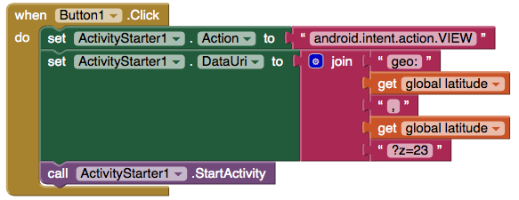
To view this discussion on the web visit https://groups.google.com/d/msgid/mitappinventortest/3133f123-0a89-4425-a972-f6fde1e4eec8%40googlegroups.com.
--
You received this message because you are subscribed to a topic in the Google Groups "MIT App Inventor Forum" group.
To unsubscribe from this topic, visit https://groups.google.com/d/topic/mitappinventortest/ZbyrpWPXPCY/unsubscribe.
To unsubscribe from this group and all its topics, send an email to mitappinventort...@googlegroups.com.
To post to this group, send email to mitappinv...@googlegroups.com.
For more options, visit https://groups.google.com/groups/opt_out.
fadlin...@gmail.com
Dec 14, 2013, 4:37:37 PM12/14/13
to mitappinv...@googlegroups.com, fadlin...@gmail.com
On Saturday, 14 December 2013 12:50:42 UTC-8, Ankush Gupta wrote:
> Can you post a screenshot of what you have attempted? Something like this should probably get the job done:
>
>
>
>
>
> Can you post a screenshot of what you have attempted? Something like this should probably get the job done:
>
>
>
>
>
Ankush Gupta
Dec 14, 2013, 5:10:49 PM12/14/13
to mitappinv...@googlegroups.com, fadlin...@gmail.com
You can take a screenshot and attach it.
The blocks that I posted launches an Activity (an application, in this case Google Maps assuming it's installed) to handle the Intent (a special message) with the information as following
- Action = android.intent.action.VIEW
- this means that the application that handles the Intent needs to be able to perform a VIEW action on it
- DataUri = "geo:" longitude "," latitude "?z=23"
- in this case, "geo:" is a special prefix that indicates that this is a geographical location.
- longitude is the longitude of the location you wish to open in Google Maps
- latitude is the latitude of the location you with to open in Google Maps
- "?z=23" is a suffix that tells Google Maps how far to zoom in, with 23 being the most zoomed in as possible (and 1 showing the entire earth)
fadlin...@gmail.com
Dec 15, 2013, 5:47:31 AM12/15/13
to mitappinv...@googlegroups.com, fadlin...@gmail.com
On Saturday, 14 December 2013 14:10:49 UTC-8, Ankush Gupta wrote:
> You can take a screenshot and attach it.
>
>
> The blocks that I posted launches an Activity (an application, in this case Google Maps assuming it's installed) to handle the Intent (a special message) with the information as following
> Action = android.intent.action.VIEWthis means that the application that handles the Intent needs to be able to perform a VIEW action on itDataUri = "geo:" longitude "," latitude "?z=23"in this case, "geo:" is a special prefix that indicates that this is a geographical location.longitude is the longitude of the location you wish to open in Google Mapslatitude is the latitude of the location you with to open in Google Maps"?z=23" is a suffix that tells Google Maps how far to zoom in, with 23 being the most zoomed in as possible (and 1 showing the entire earth)
> You can take a screenshot and attach it.
>
>
> The blocks that I posted launches an Activity (an application, in this case Google Maps assuming it's installed) to handle the Intent (a special message) with the information as following
>
> On Saturday, December 14, 2013 4:37:37 PM UTC-5, fadlin...@gmail.com wrote:i dont know how to attach my block diagram.. i have search but i really confuse. there have not any button to attach.. i dont make like ur diagram.. can i ask u, from your diagram , how it function.? this is show our location or target position on maps??
hey thank you.. i have done my app.. thank for ur help. it very helpful.. right now i want to create sms system.. how to create a button when click it will sent a message and no. that was program. like a static message and no?? are that posibble to built> On Saturday, December 14, 2013 4:37:37 PM UTC-5, fadlin...@gmail.com wrote:i dont know how to attach my block diagram.. i have search but i really confuse. there have not any button to attach.. i dont make like ur diagram.. can i ask u, from your diagram , how it function.? this is show our location or target position on maps??
Ankush Gupta
Dec 15, 2013, 1:52:50 PM12/15/13
to mitappinv...@googlegroups.com, fadlin...@gmail.com
You can use the Texting component from the Social drawer! Here's an example of how to use the Texting component to text a specified number with a specific message:

You can also check out this tutorial to see some more advanced apps using the Texting component.
Reply all
Reply to author
Forward
0 new messages