ALOS2 geocode problem
259 views
Skip to first unread message

朱海雄
Apr 29, 2021, 10:35:55 PM4/29/21
to MintPy
I use 13 ALOS2 data to verify the baige landslide occurring in 2018 Nov by ISCE and MintPy, 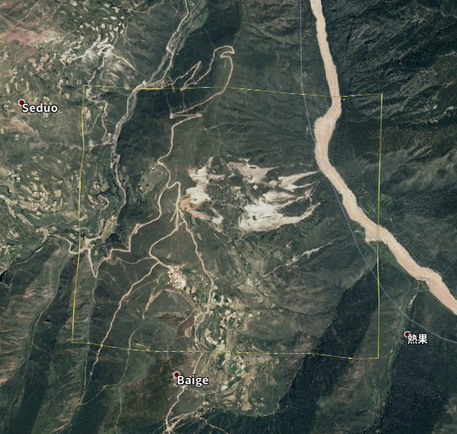
the isce command i used was:
stackStripMap.py -s /media/leslie/F/Data/ALOS-2/SLC -d /media/leslie/F/Data/ALOS-2/DEM/demLat_N31_N32_Lon_E098_E099.dem.wgs84 -m 20171127 -W interferogram -x '31.05 31.1 98.68 98.72' -t 500 -b 200 -a 2 -r 4 -S alos -u snaphu --nofocus
after unwarp I can invert the displacement in mintpy successfully , i open the geo_velocity.kmz in google earth but found the outcome location seems a litttle shift:
Figue1 shows the LandSlide in the boundingBox
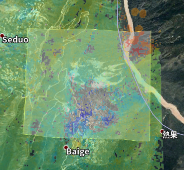
Figure 2 overlay the geo_velocity on the bounding box blue represents
the InSAR landslie by ALOS2
there is a obvious shift between the google earth and insar outcome, i wonder why this phenomenon , i also check my other topsStack results and the location is the same with googel earth.

Zhang Yunjun
Apr 29, 2021, 10:42:05 PM4/29/21
to MintPy
Hi Zhu,
You need to turn on the --zero option since ALOS-2 (stripmap I assume) SLC is focused on the zero Doppler geometry. Check the relevant discussion here: http://earthdef.caltech.edu/boards/4/topics/3737
Yunjun
朱海雄
Apr 30, 2021, 3:22:20 AM4/30/21
to min...@googlegroups.com
thank you so much your quickly reply really help me, As your solution the --zero option shoule be set during stripstack process,and I check my TerraSAR stripmap sample,it is really right!!!
before I getting your reply i think the error maybe caused by ratio of multilook,bacause in stackStripMap.py (line 324 ) the azimuth looks will multiply by 4 if the sensor is defined as alos,I wonder why?
Zhang Yunjun <yunju...@gmail.com> 于2021年4月30日周五 上午10:42写道:
--
You received this message because you are subscribed to a topic in the Google Groups "MintPy" group.
To unsubscribe from this topic, visit https://groups.google.com/d/topic/mintpy/fqQq2pzFryA/unsubscribe.
To unsubscribe from this group and all its topics, send an email to mintpy+un...@googlegroups.com.
To view this discussion on the web visit https://groups.google.com/d/msgid/mintpy/d9f1d652-ee6a-4d7b-8340-3c30cf2f6db7n%40googlegroups.com.

geolee
Apr 16, 2023, 8:30:57 AM4/16/23
to MintPy
Hello Yunjun,
I'm processing ERS and Envisat SLC via stackStripMap.py and Mintpy as well.
It's confusing whether I should turn on the --zero option when I'm setting stackStripMap.py parameters.
I can barely find some information about this.
Thank you in advance.
Zhang Yunjun 在 2021年4月30日 星期五上午10:42:05 [UTC+8] 的信中寫道:

mirzadeh...@gmail.com
Apr 17, 2023, 9:01:06 AM4/17/23
to MintPy
Hi Yunjun,
I processed the stack of the ALOS-1 dataset (raw format downloaded from the ASF service) using the ISCE and MintPy and observed this shift in my results between the ALOS-1 and Sentinel-1. Should I
turn on the --zero option for the ALOS-1 dataset processing? And how about --nofocus option?
-z, --zero Use zero Doppler geometry for processing - Default : No
--nofocus If input data is already focused to SLCs - Default : do focus
--nofocus If input data is already focused to SLCs - Default : do focus
Sincerely,
Sayyed
Zhang Yunjun
Apr 19, 2023, 1:05:56 AM4/19/23
to MintPy
Here (https://github.com/isce-framework/isce2/blob/c2d1a218020d81071574cd70033b7d673e2f5092/components/isceobj/StripmapProc/Factories.py#L61) is the zero Doppler SLC info in isce2. It's not easy to locate, unfortunately, someone could issue a PR for it!
For ALOS raw data, isce2 is focusing it into zero doppler by default.
Yunjun
Reply all
Reply to author
Forward
0 new messages