Atttibute tables not accessible for non superusers
36 views
Skip to first unread message

Severin Menard
Mar 18, 2023, 12:07:08 PM3/18/23
to mapstore-users
Version
MapStore2-geOrchestra:2022.02.xx(570f0f9f)
MapStore2:2022.02.xx(61914023)
MapStore2-geOrchestra:2022.02.xx(570f0f9f)
MapStore2:2022.02.xx(61914023)
GeoServer Version
2.20.4-georchestra
Git Revision bce43c1237283ab259a7144baf5ff511cc2609b9
Build Date 09-Dec-2022 17:16
GeoTools Version 26.4 (rev 528edf98521245d91fa38cde4fea5f5dc369ddc8)
GeoWebCache Version 1.20.2 (rev 1.20.x/7859501431095a04f5a5c57d0f1c28ef10005a17):
Git Revision bce43c1237283ab259a7144baf5ff511cc2609b9
Build Date 09-Dec-2022 17:16
GeoTools Version 26.4 (rev 528edf98521245d91fa38cde4fea5f5dc369ddc8)
GeoWebCache Version 1.20.2 (rev 1.20.x/7859501431095a04f5a5c57d0f1c28ef10005a17):
Hi,
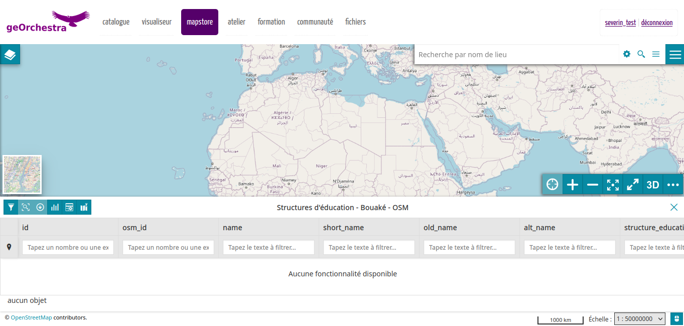
Both not connected users or connected users with simple USER rights in geOrchestra cannot access the attribute tables of any layer that is freely accessible on our SDI, while there is no problem for users with SUPERUSER rights.
Example below in video with the layer Cohesion_OSM_data:osm_cohesion_education (but I also tried with multiple other ones) accessible in visualization without being connected, the info sheet works fine on click and provides the information of the object, but the access to the attributed table requires a connection:
For a simple user, no login pop-up but the attribute table also remains empty:
On the GeoServer logs, I have this message:
2023-03-18 16:28:30,556 WARN [geotools.xsd] - Sax parser property 'http://www.oracle.com/xml/jaxp/properties/entityExpansionLimit' not recognized. Xerces version is incompatible.
Any clue to solve this?
Sincerely,
Séverin

Tobia Di Pisa
Mar 20, 2023, 6:14:43 AM3/20/23
to mapstor...@googlegroups.com
Dear Séverin,
At a first look it seems like a GS issue. I tried with a MS 2022.02.xx and a vanilla GeoServer 2.20.4 locally and all seems working fine. Did you already try the same?
Best regards,
Tobia Di Pisa
--
You received this message because you are subscribed to the Google Groups "mapstore-users" group.
To unsubscribe from this group and stop receiving emails from it, send an email to mapstore-user...@googlegroups.com.
To view this discussion on the web visit https://groups.google.com/d/msgid/mapstore-users/4148eaa0-a060-4d3a-b22c-dbac10f87129n%40googlegroups.com.
==
GeoServer Professional Services from the experts!
Visit http://bit.ly/gs-services-us for more information.
==
Dott. Ing. Tobia Di Pisa
Technical Lead / Project Manager
GeoSolutions Group
phone: +39 0584 962313
mobile: +39 340 1781783
fax: +39 0584 1660272
https://www.geosolutionsgroup.com/
http://twitter.com/geosolutions_it
-------------------------------------------------------
Con riferimento alla normativa sul trattamento dei dati personali (Reg. UE 2016/679 - Regolamento generale sulla protezione dei dati “GDPR”), si precisa che ogni circostanza inerente alla presente email (il suo contenuto, gli eventuali allegati, etc.) è un dato la cui conoscenza è riservata al/i solo/i destinatario/i indicati dallo scrivente. Se il messaggio Le è giunto per errore, è tenuta/o a cancellarlo, ogni altra operazione è illecita. Le sarei comunque grato se potesse darmene notizia.
This email is intended only for the person or entity to which it is addressed and may contain information that is privileged, confidential or otherwise protected from disclosure. We remind that - as provided by European Regulation 2016/679 “GDPR” - copying, dissemination or use of this e-mail or the information herein by anyone other than the intended recipient is prohibited. If you have received this email by mistake, please notify us immediately by telephone or e-mail.

Stefan Overkamp
Mar 20, 2023, 6:42:53 AM3/20/23
to mapstor...@googlegroups.com
Hi,
I would look on the security configuration in Geoserver:
I would look on the security configuration in Geoserver:
- (data rules) reading access to the workspace or the specific layers of the workspace for the (unauthenticated) users
- (service rules) wfs.getFeatures, wfs.DescribeFeatureType allowed for the (unauthenticated) users
To view this discussion on the web visit https://groups.google.com/d/msgid/mapstore-users/CAPO-MmTCENavc56pARihDUYa-hJyfCWTX_AfX47hdCQ6_KGQeA%40mail.gmail.com.
--
Dipl. Ing. Stefan Overkamp
Laakmannsbusch 44, 42555 Velbert
tel.: 0177 / 79 76 159
over...@posteo.de
https://mapstore.geodaten-velbert.de

Lorenzo Natali
Mar 24, 2023, 7:49:15 AM3/24/23
to mapstore-users
Yes,
I was able to find out the catalog you mention and browse the same data.
I've seen that GeoServer requires basic authentication for the request (WFS GetFeature request, POST method).
I'm Agree with Stefan, you should check the configuration of the GeoServer.
I did a couple of tests and I noticed that the WFS services works with GET requests (even GetFeature request works with HTTP GET Method), while they fail when
trying to send a POST request (as the feature grid does).
So probably you should focus your investigation on some security rule that blocks the POST requests (WFS).
Hope it helps.
Reply all
Reply to author
Forward
0 new messages