Offset (and invisible) layers when loaded from the Catalog
40 views
Skip to first unread message

Severin Menard
Sep 8, 2022, 6:08:20 PM9/8/22
to mapstore-users
Hi,
Any attempt from loading layers from https://ifl.francophonelibre.org/mapstore/#/ ends with zooming in a totally different area of the one covered by the layer (and the zoom on layer button does not change anything), while everything is fine when loading the same layers directly from GeoServer (called here IFL - Les Libres Geographes).
I guess it is related to some wrong CRS instructions, but where can I fix that?
Sincerely,
Severin

Matteo Velludini
Sep 9, 2022, 5:41:03 AM9/9/22
to mapstor...@googlegroups.com
Hi Severin,
is it possible that this problem is related to the wrong bbox associated with that layer in geoserver?
Can you check in geoserver if the bbox is correctly assigned?
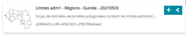
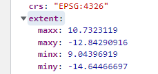
for example for this layer (Guinee_PNLTHA_hors_osm_public:GN_limites_adm1_regions_ocha_20210503)
the bbox associated is
which indeed makes the "zoom to layer extent" action zoom where no data are present.
please, let me know if this was helpful
Severin Menard
Sep 9, 2022, 4:34:13 PM9/9/22
to mapstore-users
Hi Matteo,
Thanks for your answer.
The GeoServer bbox is different than the one you found (where?) associated to the layer:

and as I mentioned in my previous message, there is no problem to load the layers from GeoServer.
So it seems there is something between GS and MapStore that changes the bbox. Any clue?
Matteo Velludini
Sep 12, 2022, 10:45:33 AM9/12/22
to mapstor...@googlegroups.com
Hi,
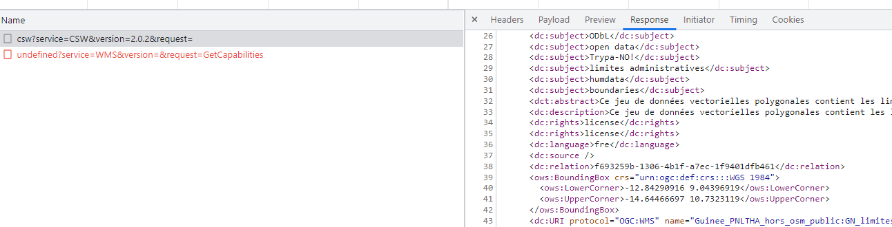
i noticed that the wrong crs are received from the get capabilities here
request
curl 'https://ifl.francophonelibre.org/geonetwork/srv/fre/csw?service=CSW&version=2.0.2&request=' \
-H 'Accept: application/json, text/plain, */*' \
-H 'Accept-Language: en-US,en;q=0.9' \
-H 'Cache-Control: no-cache' \
-H 'Connection: keep-alive' \
-H 'Content-Type: application/xml' \
-H 'Cookie: JSESSIONID=1B838532B57F3CF003E51E4882E4B80F' \
-H 'Origin: https://ifl.francophonelibre.org' \
-H 'Pragma: no-cache' \
-H 'Referer: https://ifl.francophonelibre.org/mapstore/' \
-H 'Sec-Fetch-Dest: empty' \
-H 'Sec-Fetch-Mode: cors' \
-H 'Sec-Fetch-Site: same-origin' \
-H 'User-Agent: Mozilla/5.0 (Windows NT 10.0; Win64; x64) AppleWebKit/537.36 (KHTML, like Gecko) Chrome/105.0.0.0 Safari/537.36' \
-H 'sec-ch-ua: "Google Chrome";v="105", "Not)A;Brand";v="8", "Chromium";v="105"' \
-H 'sec-ch-ua-mobile: ?0' \
-H 'sec-ch-ua-platform: "Windows"' \
--data-raw $'<csw:GetRecords xmlns:csw="http://www.opengis.net/cat/csw/2.0.2" xmlns:ogc="http://www.opengis.net/ogc" xmlns:gml="http://www.opengis.net/gml" xmlns:dc="http://purl.org/dc/elements/1.1/" xmlns:dct="http://purl.org/dc/terms/" xmlns:gmd="http://www.isotc211.org/2005/gmd" xmlns:gco="http://www.isotc211.org/2005/gco" xmlns:gmi="http://www.isotc211.org/2005/gmi" xmlns:ows="http://www.opengis.net/ows" service="CSW" version="2.0.2" resultType="results" startPosition="1" maxRecords="4"> <csw:Query typeNames="csw:Record"> <csw:ElementSetName>full</csw:ElementSetName> <csw:Constraint version="1.1.0"> <ogc:Filter> <ogc:Or>\n <ogc:PropertyIsEqualTo>\n <ogc:PropertyName>dc:type</ogc:PropertyName>\n <ogc:Literal>dataset</ogc:Literal>\n </ogc:PropertyIsEqualTo>\n <ogc:PropertyIsEqualTo>\n <ogc:PropertyName>dc:type</ogc:PropertyName>\n <ogc:Literal>http://purl.org/dc/dcmitype/Dataset</ogc:Literal>\n </ogc:PropertyIsEqualTo>\n </ogc:Or> </ogc:Filter> </csw:Constraint> </csw:Query> </csw:GetRecords>' \
--compressed
So mapstore is using what geoserver is returning
Severin Menard
Sep 20, 2022, 4:42:24 PM9/20/22
to mapstore-users
Hi,
Someone from the geOrchestra community told me there is (was?) actually a bug with the Zoom to layer extent function. A way to bypass it is to add these settings in the MapStore contexts within the Catalog plugin:
{
"cfg": {
"zoomToLayer": false,
"wrap": true
},
"override": {}
}
and also to add this in the LocalConfig.json file, in the desktop section:
{
"name": "MetadataExplorer",
"cfg": {
"zoomToLayer": false,
"wrap": true
}
"name": "MetadataExplorer",
"cfg": {
"zoomToLayer": false,
"wrap": true
}
and this works: no (wrong) zoom to layer when loading a layer. But of course if you click on the Zoom to layer button, you still end up at the wrong place.
The bug may have been solved in the last MapStore version for geOrchestra, but I have been advised to wait for the next one.
Sincerely,
Severin
Matteo Velludini
Oct 11, 2022, 11:09:59 AM10/11/22
to mapstore-users
Reply all
Reply to author
Forward
0 new messages