RE: RE: RE: RE: RE:[mapstore-users] Cannot enable WMS Time vizualization

Maël REBOUX
Hi !
Some news.
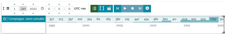
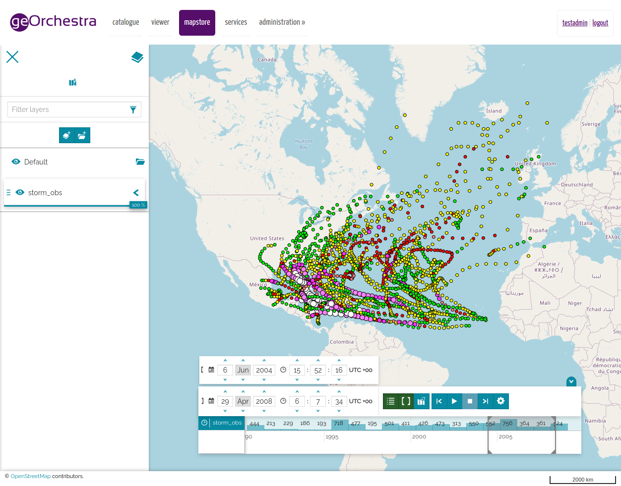
I succeed in setting up a WMS Time layer in GeoServer and was able to obtain the WMS Time Controller in MapStore.
BUT : I want to test the same layer but on a vanilla GeoServer, not our geOrchestra GeoServer. And it is not working.
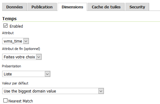
In the geOrchestra GeoServer (v 2.17.2) we choose this settings for our layer :
Dimensions :
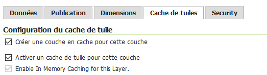
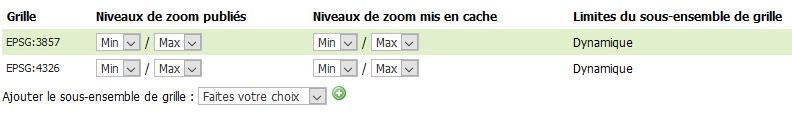
Cached layer + tile cache service
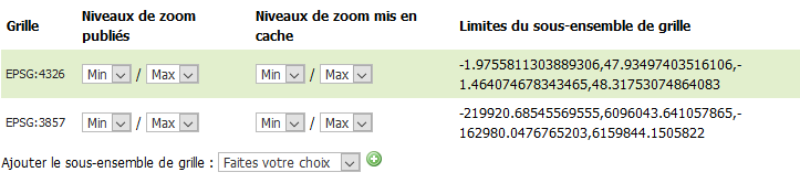
2 gridsets :
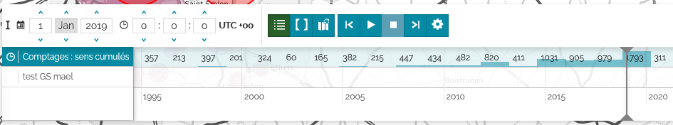
The result of loading the layer in MapStore : working !
Now, in the vanilla GeoServer (v 2.17.5), same configuration :
Dimensions :
Cached layer + tile cache service
2 gridsets :
The result of loading the layer in MapStore : the layer is not identified as WMS time
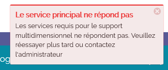
What could be missing in the Vanilla GeoServer ?
De : mapstor...@googlegroups.com <mapstor...@googlegroups.com> De la part de Maël REBOUX
Envoyé : mercredi 24 mars 2021 16:37
À : mapstor...@googlegroups.com
Objet : [NEWSLETTER] *** SPAM RISK *** RE: RE: RE: RE:[mapstore-users] Cannot enable WMS Time vizualization
That was it Lorenzo !
Since we have disable third party plugins : the timeline plugins is working.
FYI : one have to set up only a WMS layer. No need to have a WMTS layer.
But I want to make more tests because I saw a different behaviout between our georchestra geoserver and a vanilla geoserver.
Maël
De : mapstor...@googlegroups.com <mapstor...@googlegroups.com> De la part de Lorenzo Natali
Envoyé : mardi 23 mars 2021 13:08
À : mapstore-users <mapstor...@googlegroups.com>
Objet : Re: RE: RE: RE:[mapstore-users] Cannot enable WMS Time vizualization
Hi
Everything looks correct...
If you are working with GeOrchestra, I noticed that some extensions do not correctly update the map layout, and then they break the position (bottom) property that is needed to timeline, so the timeline is present but not visible.
So you could try to uninstall your extensions to see if this solves the problem.
Please let me know
Il giorno venerdì 19 marzo 2021 alle 15:34:49 UTC+1 m.re...@rennesmetropole.fr ha scritto:
Well.
I read many times your answer : " WMS layer from a GeoServer with WMTS-Multidim plugin installed".
So I load the same layer with 3 differents ways :
- WMS layer from GeoServer WMS
- WMTS layer from the GeoWebCache embedded in GeoServer
- WMS (WMS-C) layer from the GeoWebCache embedded in GeoServer
Anyway : the timeline controls are not present.
Note : I can getFeatureInfo with the WMS-C layer.
What do I miss ?
De : Maël REBOUX [mailto:m.re...@rennesmetropole.fr]
Envoyé : vendredi 19 mars 2021 15:19
À : mapstor...@googlegroups.com
Objet : RE: RE: RE: RE:[mapstore-users] Cannot enable WMS Time vizualization
OK.
We have updated the proxy.properties file and the hostnameWhitelist
So I can load the WMS and WMTS layer in mapstore.
Now, I have the WMS layaer and WMTS layer loaded in my map.
But nothing happens : no timeline controls :(
And I cannot query the WMTS layer
Is it linked ?
<?xml version="1.0" encoding="UTF-8"?>
<ExceptionReport version="1.1.0" xmlns="http://www.opengis.net/ows/1.1"
xmlns:xsi="http://www.w3.org/2001/XMLSchema-instance"
xsi:schemaLocation="http://www.opengis.net/ows/1.1 http://geowebcache.org/schema/ows/1.1.0/owsExceptionReport.xsd">
<Exception exceptionCode="InvalidParameterValue" locator="TILEMATRIX">
<ExceptionText>Unknown TILEMATRIX </ExceptionText>
</Exception>
</ExceptionReport>
De : mapstor...@googlegroups.com [mailto:mapstor...@googlegroups.com] De la part de Maël REBOUX
Envoyé : jeudi 18 mars 2021 16:23
À : mapstor...@googlegroups.com
Objet : [NEWSLETTER] RE: RE: RE:[mapstore-users] Cannot enable WMS Time vizualization
OK. I'm on the way.
I set up a all new (vanilla) GeoServer
And install the jar in the /lib/ directory
Mount a layer
Check the DescribeDomains query --> I've got a <SpaceDomain> answer
So all seems good but…
I cannot acces to my new GS from mapstore2 : nothing just an error message.
Is there something to configure in the LocalConfig.json ?
This server is on my LAN
De : mapstor...@googlegroups.com [mailto:mapstor...@googlegroups.com] De la part de Maël REBOUX
Envoyé : mercredi 17 mars 2021 10:42
À : mapstor...@googlegroups.com
Objet : [NEWSLETTER] RE: RE:[mapstore-users] Cannot enable WMS Time vizualization
Thank you for these complete answer Lorenzo.
We don't have the where WMTS-Multidim extension installed in our GeoServer.
I'll install it and come back here after.
De : mapstor...@googlegroups.com [mailto:mapstor...@googlegroups.com] De la part de Lorenzo Natali
Envoyé : mardi 16 mars 2021 18:01
À : mapstore-users <mapstor...@googlegroups.com>
Objet : Re: RE:[mapstore-users] Cannot enable WMS Time vizualization
Hi,
the documentation is unclear about this point, as I specified in this issue, I'm going to change the doc to make this point less hard for users.
You need the WMTS-Multidim extension, but you need to use WMS layers anyway. This because MapStore doesn't support WMS time values in WMS GetCapabilities yet, and it works only using the extension's services.
The support for time value in WMTS layers is still to be implemented, too.
If you want to follow progress of them:
- issue to support time values from WMS Capabilities
- issue to support time parameter WMTS layers
So to use the timeline you need WMS layers from a server where WMTS-Multidim extension is installed.
About creating a context, I successfully created a context in geOrchestra adding the Timeline plugin (the playback plugin is included automatically, hidden in the UI) and a WMS layer from a GeoServer with WMTS-Multidim plugin installed).
So the first attempt was correct, we need to find out why the timeline was not shown . Do you have more information about this (errors in console, failing requests ...)?
Il giorno martedì 16 marzo 2021 alle 15:07:28 UTC+1 m.re...@rennesmetropole.fr ha scritto:
Maybe a MS2 : I had to delete my map because it still use a bad tile matrix despite erasing a reloading several times the layer. Should I create an issue ?
So : all new map context with the same layer.
Here the GetFeatureInfo query is better :
/geoserver/gwc/service/wmts?layer=trp_rout:v_comptage_station_stats
&service=WMTS
&request=GetFeatureInfo
&infoformat=text/plain
&style=point
&tilematrix={"identifier":"EPSG:3857:15","ranges":{"cols":{"min":"16204","max":"16250"},"rows":{"min":"11347","max":"11399"}}}
&tilematrixset=EPSG:3857
&tilecol=16232
&tilerow=11375
&i=94
&j=255
But I still get a http 400 bad request answer.
De : mapstor...@googlegroups.com [mailto:mapstor...@googlegroups.com] De la part de Maël REBOUX
Envoyé : mardi 16 mars 2021 14:28
À : mapstor...@googlegroups.com
Objet : [NEWSLETTER] RE:[mapstore-users] Cannot enable WMS Time vizualization
Well. I just detected that I get a 400 http error while clicking on one of of the point of my layer.
I don't know if it related to my problem but obviously MS2 create a request beside ?
#GWC demo
/geoserver/gwc/service/wmts?VERSION=1.0.0&LAYER=trp_rout:v_comptage_station_stats
&SERVICE=WMTS
&REQUEST=GetFeatureInfo
&INFOFORMAT=text/html
&FORMAT=image/png
&STYLE=
&TILEMATRIX=EPSG:3857:13
&TILEMATRIXSET=EPSG:3857
&TileCol=4057
&TileRow=2846
&I=6
&J=71
# mapstore
&service=WMTS
&request=GetFeatureInfo
&infoformat=text/plain
&style=point
&tilematrix={"identifier":"EPSG:3857:13","ranges":{"cols":{"min":"4051","max":"4062"},"rows":{"min":"2836","max":"2849"}}}
&tilematrixset=EPSG:3857
&tilecol=4057
&tilerow=2846
&i=6
&j=70
The error
<?xml version="1.0" encoding="UTF-8"?>
<ExceptionReport version="1.1.0" xmlns="http://www.opengis.net/ows/1.1" xmlns:xsi="http://www.w3.org/2001/XMLSchema-instance" xsi:schemaLocation="http://www.opengis.net/ows/1.1 http://geowebcache.org/schema/ows/1.1.0/owsExceptionReport.xsd">
<Exception exceptionCode="InvalidParameterValue" locator="TILEMATRIX">
<ExceptionText>
Unknown TILEMATRIX {"identifier":"EPSG:3857:13","ranges":{"cols":{"min":"4051","max":"4062"},"rows":{"min":"2836","max":"2849"}}}
</ExceptionText>
</Exception>
</ExceptionReport>
De : mapstor...@googlegroups.com [mailto:mapstor...@googlegroups.com] De la part de Maël REBOUX
Envoyé : mardi 16 mars 2021 12:08
À : 'mapstore-users' <mapstor...@googlegroups.com>
Objet : [NEWSLETTER] [mapstore-users] Cannot enable WMS Time vizualization
Hello from Britanny
I'm currently trying to set up a map context to show datas with a time dimension.
So :
I set up a WMS layer in GeoServer with a date attribute. The capacities seem OK because I see :
<Dimension name="time" default="current" units="ISO8601">1995-01-01T00:00:00.000Z/2021-01-01T00:00:00.000Z/PT1S</Dimension>
Then I set up a new map context with the Timeline plugin enabled.
Then I load this map context but nothing appens : no timeline.
Big disappointment, I read here this advertise : "Timeline actually works only with WMTS-Multidim extension (WMS time in capabilities is not fully supported). From now on, the layers that the Timeline can manage will be addressed as time layers."
Okay… let's configure a cached version of my layer in the embeded GeoWebCache.
Quite easy. I think all is correct because I see this in the capacities :
<Dimension><ows:Identifier>time</ows:Identifier><Default>current</Default><Value>1995-01-01T00:00:00.000Z--2021-01-01T00:00:00.000Z</Value></Dimension>
The I modify my map to load the WMTS version layer. But still nothing : no timeline.
As I read the plugin documentation, TimeLine requires the playback plugin
https://mapstore.geo-solutions.it/mapstore/docs/api/plugins#plugins.Timeline
https://mapstore.geo-solutions.it/mapstore/docs/api/plugins#plugins.Playback
OK but the doc mention the TimeLine reducer.
Should I always create a specific JSON configuration in the timeline plugin to make it work ?
As I understand the reducer is here only to reduce bounds in case of big datas.
I believed that the time functionality is auto setting when you load a wms time layer. Isn't it ?
Thank you for your advices and help.
Maël REBOUX
Service Information Géographique Rennes Métropole
Chargé de mission données et diffusion02 99 86 63 71
Twitter : @mael_reboux_ig
https://public.sig.rennesmetropole.fr | https://data.rennesmetropole.fr
--
You received this message because you are subscribed to the Google Groups "mapstore-users" group.
To unsubscribe from this group and stop receiving emails from it, send an email to mapstore-user...@googlegroups.com.
To view this discussion on the web visit https://groups.google.com/d/msgid/mapstore-users/007301d71a54%2495c80e10%24c1582a30%24%40rennesmetropole.fr.--
You received this message because you are subscribed to the Google Groups "mapstore-users" group.
To unsubscribe from this group and stop receiving emails from it, send an email to mapstore-user...@googlegroups.com.To view this discussion on the web visit https://groups.google.com/d/msgid/mapstore-users/00a401d71a68%2433ce7b90%249b6b72b0%24%40rennesmetropole.fr.
--
You received this message because you are subscribed to the Google Groups "mapstore-users" group.
To unsubscribe from this group and stop receiving emails from it, send an email to mapstore-user...@googlegroups.com.
To view this discussion on the web visit https://groups.google.com/d/msgid/mapstore-users/15bdf8b0-6fca-490d-b09d-120cec286c8cn%40googlegroups.com.--
You received this message because you are subscribed to the Google Groups "mapstore-users" group.
To unsubscribe from this group and stop receiving emails from it, send an email to mapstore-user...@googlegroups.com.
To view this discussion on the web visit https://groups.google.com/d/msgid/mapstore-users/00aa01d71b11%24ce5463b0%246afd2b10%24%40rennesmetropole.fr.--
You received this message because you are subscribed to the Google Groups "mapstore-users" group.
To unsubscribe from this group and stop receiving emails from it, send an email to mapstore-user...@googlegroups.com.
To view this discussion on the web visit https://groups.google.com/d/msgid/mapstore-users/001d01d71c0a%24943019f0%24bc904dd0%24%40rennesmetropole.fr.
--
You received this message because you are subscribed to the Google Groups "mapstore-users" group.
To unsubscribe from this group and stop receiving emails from it, send an email to mapstore-user...@googlegroups.com.
To view this discussion on the web visit https://groups.google.com/d/msgid/mapstore-users/55a75cb6-7e43-4b92-a9e2-6e0bf7a3f420n%40googlegroups.com.
--
You received this message because you are subscribed to the Google Groups "mapstore-users" group.
To unsubscribe from this group and stop receiving emails from it, send an email to mapstore-user...@googlegroups.com.
To view this discussion on the web visit https://groups.google.com/d/msgid/mapstore-users/00e201d720c3%24833c5600%2489b50200%24%40rennesmetropole.fr.
