Jason exportbto shp

Estudio CAD

Mauro Bartolomeoli

Hi.. i need the anotations in my map export yo shp.. but dont work convert json2shp i need help.. tus a lot oscar
--
You received this message because you are subscribed to the Google Groups "mapstore-developers" group.
To unsubscribe from this group and stop receiving emails from it, send an email to mapstore-develo...@googlegroups.com.
To view this discussion on the web, visit https://groups.google.com/d/msgid/mapstore-developers/594d9fb7-2ec5-465e-bd57-b4ad0b239d2bo%40googlegroups.com.
Regards,
Mauro Bartolomeoli
==
GeoServer Professional Services from the experts! Visit http://goo.gl/it488V for more information.
==
Dott. Mauro Bartolomeoli
@mauro_bart
Technical Lead
GeoSolutions S.A.S.
Via di Montramito 3/A
55054 Massarosa (LU)
Italy
mobile: +39 393 904 1756
phone: +39 0584 962313
fax: +39 0584 1660272
http://www.geo-solutions.it
http://twitter.com/geosolutions_it
-------------------------------------------------------
Con riferimento alla normativa sul trattamento dei dati personali (Reg. UE 2016/679 - Regolamento generale sulla protezione dei dati “GDPR”), si precisa che ogni circostanza inerente alla presente email (il suo contenuto, gli eventuali allegati, etc.) è un dato la cui conoscenza è riservata al/i solo/i destinatario/i indicati dallo scrivente. Se il messaggio Le è giunto per errore, è tenuta/o a cancellarlo, ogni altra operazione è illecita. Le sarei comunque grato se potesse darmene notizia.
This email is intended only for the person or entity to which it is addressed and may contain information that is privileged, confidential or otherwise protected from disclosure. We remind that - as provided by European Regulation 2016/679 “GDPR” - copying, dissemination or use of this e-mail or the information herein by anyone other than the intended recipient is prohibited. If you have received this email by mistake, please notify us immediately by telephone or e-mail.
Estudio CAD
To view this discussion on the web, visit https://groups.google.com/d/msgid/mapstore-developers/CAMyxr67jBXJgb0D3Z1LOCV_8YfCcHoUAm9JP1p9nVpNWgySCFA%40mail.gmail.com.
Mauro Bartolomeoli
To view this discussion on the web, visit https://groups.google.com/d/msgid/mapstore-developers/CAAQz6AeudpSPsJF%3D3BkO3%2BXWFS7tPAgDJbMcMrA_KRx17zFcLQ%40mail.gmail.com.

Matteo Velludini
You should take(in a new file) every single FeatureCollection in the array in order to do the conversion.
To view this discussion on the web, visit https://groups.google.com/d/msgid/mapstore-developers/CAMyxr67JU8GGNsE5ZLx7wH9X7%3DvqM_yspHTCyCm6%2Bvi8H0Reug%40mail.gmail.com.
Regards,
Matteo Velludini
==
GeoServer Professional Services from the experts! Visit http://goo.gl/it488V for more information.
==
Matteo Velludini
Software Engineer
GeoSolutions S.A.S.
Via di Montramito 3/A
55054 Massarosa (LU)
Italy
AVVERTENZE AI SENSI DEL D.Lgs. 196/2003
Le informazioni contenute in questo messaggio di posta elettronica e/o nel/i file/s allegato/i sono da considerarsi strettamente riservate. Il loro utilizzo è consentito esclusivamente al destinatario del messaggio, per le finalità indicate nel messaggio stesso. Qualora riceviate questo messaggio senza esserne il destinatario, Vi preghiamo cortesemente di darcene notizia via e-mail e di procedere alla distruzione del messaggio stesso, cancellandolo dal Vostro sistema. Conservare il messaggio stesso, divulgarlo anche in parte, distribuirlo ad altri soggetti, copiarlo, od utilizzarlo per finalità diverse, costituisce comportamento contrario ai principi dettati dal D.Lgs. 196/2003.
The information in this message and/or attachments, is intended solely for the attention and use of the named addressee(s) and may be confidential or proprietary in nature or covered by the provisions of privacy act (Legislative Decree June, 30 2003, no.196 - Italy's New Data Protection Code).Any use not in accord with its purpose, any disclosure, reproduction, copying, distribution, or either dissemination, either whole or partial, is strictly forbidden except previous formal approval of the named addressee(s). If you are not the intended recipient, please contact immediately the sender by telephone, fax or e-mail and delete the information in this message that has been received in error. The sender does not give any warranty or accept liability as the content, accuracy or completeness of sent messages and accepts no responsibility for changes made after they were sent or for other risks which arise as a result of e-mail transmission, viruses, etc.
Matteo Velludini
Estudio CAD
To view this discussion on the web, visit https://groups.google.com/d/msgid/mapstore-developers/CAMyxr67JU8GGNsE5ZLx7wH9X7%3DvqM_yspHTCyCm6%2Bvi8H0Reug%40mail.gmail.com.
Estudio CAD
To view this discussion on the web, visit https://groups.google.com/d/msgid/mapstore-developers/CAE%3D21_e%2BgTJH8QMNmA5FpDgt-1JZpsj%3DVADygES2md1WgqpnCA%40mail.gmail.com.

Erwin Sterrenburg
On Wednesday, June 24, 2020 at 2:00:17 PM UTC+2, Estudio CAD wrote:
hi tks for the answer.. this is my annotation file tks a lot
El mié., 24 jun. 2020 a las 3:33, Mauro Bartolomeoli (<mauro.ba...@geo-solutions.it>) escribió:
Good morning Oscar,can you attach a GeoJSON file produced from your export, so that we can test it?Mauro
Il giorno mar 23 giu 2020 alle ore 19:01 Estudio CAD <ans...@gmail.com> ha scritto:
hi, thks for answer but i try export and qgis and other cant open de json file create in annotations... not recognized format...etc thk for helpme oscar from argentina
El mar., 23 jun. 2020 a las 12:52, Mauro Bartolomeoli (<mauro.ba...@geo-solutions.it>) escribió:
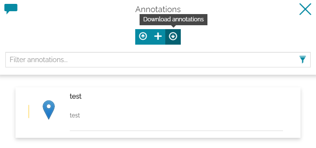
Hi Oscar,you can currently export Annotations directly from the Annotations panel:They will be exported in GeoJSON format. Shapefile is not supported, but you should be able to use GeoJSON with other tools, or convert it to Shapefile with GDAL or other utilities.Mauro
Il giorno lun 22 giu 2020 alle ore 22:05 Estudio CAD <ans...@gmail.com> ha scritto:
Hi.. i need the anotations in my map export yo shp.. but dont work convert json2shp i need help.. tus a lot oscar
--
You received this message because you are subscribed to the Google Groups "mapstore-developers" group.
To unsubscribe from this group and stop receiving emails from it, send an email to mapstore-developers+unsub...@googlegroups.com.
To view this discussion on the web, visit https://groups.google.com/d/msgid/mapstore-developers/594d9fb7-2ec5-465e-bd57-b4ad0b239d2bo%40googlegroups.com.
----Regards,
Mauro Bartolomeoli
==
GeoServer Professional Services from the experts! Visit http://goo.gl/it488V for more information.
==
Dott. Mauro Bartolomeoli
@mauro_bart
Technical Lead
GeoSolutions S.A.S.
Via di Montramito 3/A
55054 Massarosa (LU)
Italymobile: +39 393 904 1756
phone: +39 0584 962313
fax: +39 0584 1660272
http://www.geo-solutions.it
http://twitter.com/geosolutions_it
-------------------------------------------------------Con riferimento alla normativa sul trattamento dei dati personali (Reg. UE 2016/679 - Regolamento generale sulla protezione dei dati “GDPR”), si precisa che ogni circostanza inerente alla presente email (il suo contenuto, gli eventuali allegati, etc.) è un dato la cui conoscenza è riservata al/i solo/i destinatario/i indicati dallo scrivente. Se il messaggio Le è giunto per errore, è tenuta/o a cancellarlo, ogni altra operazione è illecita. Le sarei comunque grato se potesse darmene notizia.
This email is intended only for the person or entity to which it is addressed and may contain information that is privileged, confidential or otherwise protected from disclosure. We remind that - as provided by European Regulation 2016/679 “GDPR” - copying, dissemination or use of this e-mail or the information herein by anyone other than the intended recipient is prohibited. If you have received this email by mistake, please notify us immediately by telephone or e-mail.
You received this message because you are subscribed to the Google Groups "mapstore-developers" group.
To unsubscribe from this group and stop receiving emails from it, send an email to mapstore-developers+unsub...@googlegroups.com.
To view this discussion on the web, visit https://groups.google.com/d/msgid/mapstore-developers/CAMyxr67jBXJgb0D3Z1LOCV_8YfCcHoUAm9JP1p9nVpNWgySCFA%40mail.gmail.com.
--
You received this message because you are subscribed to the Google Groups "mapstore-developers" group.
To unsubscribe from this group and stop receiving emails from it, send an email to mapstore-developers+unsub...@googlegroups.com.
To view this discussion on the web, visit https://groups.google.com/d/msgid/mapstore-developers/CAAQz6AeudpSPsJF%3D3BkO3%2BXWFS7tPAgDJbMcMrA_KRx17zFcLQ%40mail.gmail.com.
----Regards,
Mauro Bartolomeoli
==
GeoServer Professional Services from the experts! Visit http://goo.gl/it488V for more information.
==
Dott. Mauro Bartolomeoli
@mauro_bart
Technical Lead
GeoSolutions S.A.S.
Via di Montramito 3/A
55054 Massarosa (LU)
Italymobile: +39 393 904 1756
phone: +39 0584 962313
fax: +39 0584 1660272
http://www.geo-solutions.it
http://twitter.com/geosolutions_it
-------------------------------------------------------Con riferimento alla normativa sul trattamento dei dati personali (Reg. UE 2016/679 - Regolamento generale sulla protezione dei dati “GDPR”), si precisa che ogni circostanza inerente alla presente email (il suo contenuto, gli eventuali allegati, etc.) è un dato la cui conoscenza è riservata al/i solo/i destinatario/i indicati dallo scrivente. Se il messaggio Le è giunto per errore, è tenuta/o a cancellarlo, ogni altra operazione è illecita. Le sarei comunque grato se potesse darmene notizia.
This email is intended only for the person or entity to which it is addressed and may contain information that is privileged, confidential or otherwise protected from disclosure. We remind that - as provided by European Regulation 2016/679 “GDPR” - copying, dissemination or use of this e-mail or the information herein by anyone other than the intended recipient is prohibited. If you have received this email by mistake, please notify us immediately by telephone or e-mail.
You received this message because you are subscribed to the Google Groups "mapstore-developers" group.
To unsubscribe from this group and stop receiving emails from it, send an email to mapstore-developers+unsub...@googlegroups.com.
Estudio CAD
Usa iface para acceder a la interfaz de la API de QGIS o digita help(iface) para más información
Aviso de advertencia: digitar instrucciones desde una fuente no confiable puede conllevar a pérdida o fuga de datos
# -*- coding: utf-8 -*-
import json
from PyQt5.QtGui import QColor, QFont
from qgis.core import QgsPalLayerSettings, QgsTextFormat
from qgis.core import QgsTextBufferSettings, QgsVectorLayerSimpleLabeling
def turnOnLabels(layer, expression):
layer_settings = QgsPalLayerSettings()
text_format = QgsTextFormat()
text_format.setFont(QFont("Arial", 10))
Traceback (most recent call last):
File "C:\PROGRA~1\QGIS3~1.12\apps\Python37\lib\code.py", line 63, in runsource
code = self.compile(source, filename, symbol)
File "C:\PROGRA~1\QGIS3~1.12\apps\Python37\lib\codeop.py", line 168, in __call__
return _maybe_compile(self.compiler, source, filename, symbol)
File "C:\PROGRA~1\QGIS3~1.12\apps\Python37\lib\codeop.py", line 99, in _maybe_compile
raise err1
File "C:\PROGRA~1\QGIS3~1.12\apps\Python37\lib\codeop.py", line 87, in _maybe_compile
code1 = compiler(source + "\n", filename, symbol)
File "C:\PROGRA~1\QGIS3~1.12\apps\Python37\lib\codeop.py", line 133, in __call__
codeob = compile(source, filename, symbol, self.flags, 1)
File "<input>", line 1
text_format.setFont(QFont("Arial", 10))
^
IndentationError: unexpected indent
text_format.setSize(10)
Traceback (most recent call last):
File "C:\PROGRA~1\QGIS3~1.12\apps\Python37\lib\code.py", line 63, in runsource
code = self.compile(source, filename, symbol)
File "C:\PROGRA~1\QGIS3~1.12\apps\Python37\lib\codeop.py", line 168, in __call__
return _maybe_compile(self.compiler, source, filename, symbol)
File "C:\PROGRA~1\QGIS3~1.12\apps\Python37\lib\codeop.py", line 99, in _maybe_compile
raise err1
File "C:\PROGRA~1\QGIS3~1.12\apps\Python37\lib\codeop.py", line 87, in _maybe_compile
code1 = compiler(source + "\n", filename, symbol)
File "C:\PROGRA~1\QGIS3~1.12\apps\Python37\lib\codeop.py", line 133, in __call__
codeob = compile(source, filename, symbol, self.flags, 1)
File "<input>", line 1
text_format.setSize(10)
^
IndentationError: unexpected indent
buffer_settings = QgsTextBufferSettings()
Traceback (most recent call last):
File "C:\PROGRA~1\QGIS3~1.12\apps\Python37\lib\code.py", line 63, in runsource
code = self.compile(source, filename, symbol)
File "C:\PROGRA~1\QGIS3~1.12\apps\Python37\lib\codeop.py", line 168, in __call__
return _maybe_compile(self.compiler, source, filename, symbol)
File "C:\PROGRA~1\QGIS3~1.12\apps\Python37\lib\codeop.py", line 99, in _maybe_compile
raise err1
File "C:\PROGRA~1\QGIS3~1.12\apps\Python37\lib\codeop.py", line 87, in _maybe_compile
code1 = compiler(source + "\n", filename, symbol)
File "C:\PROGRA~1\QGIS3~1.12\apps\Python37\lib\codeop.py", line 133, in __call__
codeob = compile(source, filename, symbol, self.flags, 1)
File "<input>", line 1
buffer_settings = QgsTextBufferSettings()
^
IndentationError: unexpected indent
buffer_settings.setEnabled(True)
Traceback (most recent call last):
File "C:\PROGRA~1\QGIS3~1.12\apps\Python37\lib\code.py", line 63, in runsource
code = self.compile(source, filename, symbol)
File "C:\PROGRA~1\QGIS3~1.12\apps\Python37\lib\codeop.py", line 168, in __call__
return _maybe_compile(self.compiler, source, filename, symbol)
File "C:\PROGRA~1\QGIS3~1.12\apps\Python37\lib\codeop.py", line 99, in _maybe_compile
raise err1
File "C:\PROGRA~1\QGIS3~1.12\apps\Python37\lib\codeop.py", line 87, in _maybe_compile
code1 = compiler(source + "\n", filename, symbol)
File "C:\PROGRA~1\QGIS3~1.12\apps\Python37\lib\codeop.py", line 133, in __call__
codeob = compile(source, filename, symbol, self.flags, 1)
File "<input>", line 1
buffer_settings.setEnabled(True)
^
IndentationError: unexpected indent
buffer_settings.setSize(0.10)
Traceback (most recent call last):
File "C:\PROGRA~1\QGIS3~1.12\apps\Python37\lib\code.py", line 63, in runsource
code = self.compile(source, filename, symbol)
File "C:\PROGRA~1\QGIS3~1.12\apps\Python37\lib\codeop.py", line 168, in __call__
return _maybe_compile(self.compiler, source, filename, symbol)
File "C:\PROGRA~1\QGIS3~1.12\apps\Python37\lib\codeop.py", line 99, in _maybe_compile
raise err1
File "C:\PROGRA~1\QGIS3~1.12\apps\Python37\lib\codeop.py", line 87, in _maybe_compile
code1 = compiler(source + "\n", filename, symbol)
File "C:\PROGRA~1\QGIS3~1.12\apps\Python37\lib\codeop.py", line 133, in __call__
codeob = compile(source, filename, symbol, self.flags, 1)
File "<input>", line 1
buffer_settings.setSize(0.10)
^
IndentationError: unexpected indent
buffer_settings.setColor(QColor("black"))
Traceback (most recent call last):
File "C:\PROGRA~1\QGIS3~1.12\apps\Python37\lib\code.py", line 63, in runsource
code = self.compile(source, filename, symbol)
File "C:\PROGRA~1\QGIS3~1.12\apps\Python37\lib\codeop.py", line 168, in __call__
return _maybe_compile(self.compiler, source, filename, symbol)
File "C:\PROGRA~1\QGIS3~1.12\apps\Python37\lib\codeop.py", line 99, in _maybe_compile
raise err1
File "C:\PROGRA~1\QGIS3~1.12\apps\Python37\lib\codeop.py", line 87, in _maybe_compile
code1 = compiler(source + "\n", filename, symbol)
File "C:\PROGRA~1\QGIS3~1.12\apps\Python37\lib\codeop.py", line 133, in __call__
codeob = compile(source, filename, symbol, self.flags, 1)
File "<input>", line 1
buffer_settings.setColor(QColor("black"))
^
IndentationError: unexpected indent
text_format.setBuffer(buffer_settings)
Traceback (most recent call last):
File "C:\PROGRA~1\QGIS3~1.12\apps\Python37\lib\code.py", line 63, in runsource
code = self.compile(source, filename, symbol)
File "C:\PROGRA~1\QGIS3~1.12\apps\Python37\lib\codeop.py", line 168, in __call__
return _maybe_compile(self.compiler, source, filename, symbol)
File "C:\PROGRA~1\QGIS3~1.12\apps\Python37\lib\codeop.py", line 99, in _maybe_compile
raise err1
File "C:\PROGRA~1\QGIS3~1.12\apps\Python37\lib\codeop.py", line 87, in _maybe_compile
code1 = compiler(source + "\n", filename, symbol)
File "C:\PROGRA~1\QGIS3~1.12\apps\Python37\lib\codeop.py", line 133, in __call__
codeob = compile(source, filename, symbol, self.flags, 1)
File "<input>", line 1
text_format.setBuffer(buffer_settings)
^
IndentationError: unexpected indent
layer_settings.setFormat(text_format)
Traceback (most recent call last):
File "C:\PROGRA~1\QGIS3~1.12\apps\Python37\lib\code.py", line 63, in runsource
code = self.compile(source, filename, symbol)
File "C:\PROGRA~1\QGIS3~1.12\apps\Python37\lib\codeop.py", line 168, in __call__
return _maybe_compile(self.compiler, source, filename, symbol)
File "C:\PROGRA~1\QGIS3~1.12\apps\Python37\lib\codeop.py", line 99, in _maybe_compile
raise err1
File "C:\PROGRA~1\QGIS3~1.12\apps\Python37\lib\codeop.py", line 87, in _maybe_compile
code1 = compiler(source + "\n", filename, symbol)
File "C:\PROGRA~1\QGIS3~1.12\apps\Python37\lib\codeop.py", line 133, in __call__
codeob = compile(source, filename, symbol, self.flags, 1)
File "<input>", line 1
layer_settings.setFormat(text_format)
^
IndentationError: unexpected indent
layer_settings.fieldName = expression
Traceback (most recent call last):
File "C:\PROGRA~1\QGIS3~1.12\apps\Python37\lib\code.py", line 63, in runsource
code = self.compile(source, filename, symbol)
File "C:\PROGRA~1\QGIS3~1.12\apps\Python37\lib\codeop.py", line 168, in __call__
return _maybe_compile(self.compiler, source, filename, symbol)
File "C:\PROGRA~1\QGIS3~1.12\apps\Python37\lib\codeop.py", line 99, in _maybe_compile
raise err1
File "C:\PROGRA~1\QGIS3~1.12\apps\Python37\lib\codeop.py", line 87, in _maybe_compile
code1 = compiler(source + "\n", filename, symbol)
File "C:\PROGRA~1\QGIS3~1.12\apps\Python37\lib\codeop.py", line 133, in __call__
codeob = compile(source, filename, symbol, self.flags, 1)
File "<input>", line 1
layer_settings.fieldName = expression
^
IndentationError: unexpected indent
layer_settings.isExpression = True
Traceback (most recent call last):
File "C:\PROGRA~1\QGIS3~1.12\apps\Python37\lib\code.py", line 63, in runsource
code = self.compile(source, filename, symbol)
File "C:\PROGRA~1\QGIS3~1.12\apps\Python37\lib\codeop.py", line 168, in __call__
return _maybe_compile(self.compiler, source, filename, symbol)
File "C:\PROGRA~1\QGIS3~1.12\apps\Python37\lib\codeop.py", line 99, in _maybe_compile
raise err1
File "C:\PROGRA~1\QGIS3~1.12\apps\Python37\lib\codeop.py", line 87, in _maybe_compile
code1 = compiler(source + "\n", filename, symbol)
File "C:\PROGRA~1\QGIS3~1.12\apps\Python37\lib\codeop.py", line 133, in __call__
codeob = compile(source, filename, symbol, self.flags, 1)
File "<input>", line 1
layer_settings.isExpression = True
^
IndentationError: unexpected indent
layer_settings.placement = 4
Traceback (most recent call last):
File "C:\PROGRA~1\QGIS3~1.12\apps\Python37\lib\code.py", line 63, in runsource
code = self.compile(source, filename, symbol)
File "C:\PROGRA~1\QGIS3~1.12\apps\Python37\lib\codeop.py", line 168, in __call__
return _maybe_compile(self.compiler, source, filename, symbol)
File "C:\PROGRA~1\QGIS3~1.12\apps\Python37\lib\codeop.py", line 99, in _maybe_compile
raise err1
File "C:\PROGRA~1\QGIS3~1.12\apps\Python37\lib\codeop.py", line 87, in _maybe_compile
code1 = compiler(source + "\n", filename, symbol)
File "C:\PROGRA~1\QGIS3~1.12\apps\Python37\lib\codeop.py", line 133, in __call__
codeob = compile(source, filename, symbol, self.flags, 1)
File "<input>", line 1
layer_settings.placement = 4
^
IndentationError: unexpected indent
layer_settings.enabled = True
Traceback (most recent call last):
File "C:\PROGRA~1\QGIS3~1.12\apps\Python37\lib\code.py", line 63, in runsource
code = self.compile(source, filename, symbol)
File "C:\PROGRA~1\QGIS3~1.12\apps\Python37\lib\codeop.py", line 168, in __call__
return _maybe_compile(self.compiler, source, filename, symbol)
File "C:\PROGRA~1\QGIS3~1.12\apps\Python37\lib\codeop.py", line 99, in _maybe_compile
raise err1
File "C:\PROGRA~1\QGIS3~1.12\apps\Python37\lib\codeop.py", line 87, in _maybe_compile
code1 = compiler(source + "\n", filename, symbol)
File "C:\PROGRA~1\QGIS3~1.12\apps\Python37\lib\codeop.py", line 133, in __call__
codeob = compile(source, filename, symbol, self.flags, 1)
File "<input>", line 1
layer_settings.enabled = True
^
IndentationError: unexpected indent
layer_settings = QgsVectorLayerSimpleLabeling(layer_settings)
Traceback (most recent call last):
File "C:\PROGRA~1\QGIS3~1.12\apps\Python37\lib\code.py", line 63, in runsource
code = self.compile(source, filename, symbol)
File "C:\PROGRA~1\QGIS3~1.12\apps\Python37\lib\codeop.py", line 168, in __call__
return _maybe_compile(self.compiler, source, filename, symbol)
File "C:\PROGRA~1\QGIS3~1.12\apps\Python37\lib\codeop.py", line 99, in _maybe_compile
raise err1
File "C:\PROGRA~1\QGIS3~1.12\apps\Python37\lib\codeop.py", line 87, in _maybe_compile
code1 = compiler(source + "\n", filename, symbol)
File "C:\PROGRA~1\QGIS3~1.12\apps\Python37\lib\codeop.py", line 133, in __call__
codeob = compile(source, filename, symbol, self.flags, 1)
File "<input>", line 1
layer_settings = QgsVectorLayerSimpleLabeling(layer_settings)
^
IndentationError: unexpected indent
layer.setLabelsEnabled(True)
Traceback (most recent call last):
File "C:\PROGRA~1\QGIS3~1.12\apps\Python37\lib\code.py", line 63, in runsource
code = self.compile(source, filename, symbol)
File "C:\PROGRA~1\QGIS3~1.12\apps\Python37\lib\codeop.py", line 168, in __call__
return _maybe_compile(self.compiler, source, filename, symbol)
File "C:\PROGRA~1\QGIS3~1.12\apps\Python37\lib\codeop.py", line 99, in _maybe_compile
raise err1
File "C:\PROGRA~1\QGIS3~1.12\apps\Python37\lib\codeop.py", line 87, in _maybe_compile
code1 = compiler(source + "\n", filename, symbol)
File "C:\PROGRA~1\QGIS3~1.12\apps\Python37\lib\codeop.py", line 133, in __call__
codeob = compile(source, filename, symbol, self.flags, 1)
File "<input>", line 1
layer.setLabelsEnabled(True)
^
IndentationError: unexpected indent
layer.setLabeling(layer_settings)
Traceback (most recent call last):
File "C:\PROGRA~1\QGIS3~1.12\apps\Python37\lib\code.py", line 63, in runsource
code = self.compile(source, filename, symbol)
File "C:\PROGRA~1\QGIS3~1.12\apps\Python37\lib\codeop.py", line 168, in __call__
return _maybe_compile(self.compiler, source, filename, symbol)
File "C:\PROGRA~1\QGIS3~1.12\apps\Python37\lib\codeop.py", line 99, in _maybe_compile
raise err1
File "C:\PROGRA~1\QGIS3~1.12\apps\Python37\lib\codeop.py", line 87, in _maybe_compile
code1 = compiler(source + "\n", filename, symbol)
File "C:\PROGRA~1\QGIS3~1.12\apps\Python37\lib\codeop.py", line 133, in __call__
codeob = compile(source, filename, symbol, self.flags, 1)
File "<input>", line 1
layer.setLabeling(layer_settings)
^
IndentationError: unexpected indent
layer.triggerRepaint()
Traceback (most recent call last):
File "C:\PROGRA~1\QGIS3~1.12\apps\Python37\lib\code.py", line 63, in runsource
code = self.compile(source, filename, symbol)
File "C:\PROGRA~1\QGIS3~1.12\apps\Python37\lib\codeop.py", line 168, in __call__
return _maybe_compile(self.compiler, source, filename, symbol)
File "C:\PROGRA~1\QGIS3~1.12\apps\Python37\lib\codeop.py", line 99, in _maybe_compile
raise err1
File "C:\PROGRA~1\QGIS3~1.12\apps\Python37\lib\codeop.py", line 87, in _maybe_compile
code1 = compiler(source + "\n", filename, symbol)
File "C:\PROGRA~1\QGIS3~1.12\apps\Python37\lib\codeop.py", line 133, in __call__
codeob = compile(source, filename, symbol, self.flags, 1)
File "<input>", line 1
layer.triggerRepaint()
^
IndentationError: unexpected indent
input_file_path = unicode(r"C:\Users\NL01031\Downloads\Seguimiento Rio Salado.json")
groupName ="Annotations"
project = QgsProject.instance()
root = project.layerTreeRoot()
group = root.addGroup(groupName)
lineLayer = QgsVectorLayer("linestring?crs=epsg:4326&field=id:string(36)&field=title:string&field=description:string&index=yes", "PolyLines", "memory")
project.addMapLayer(lineLayer, False)
<QgsMapLayer: 'PolyLines' (memory)>
group.addLayer(lineLayer)
<qgis._core.QgsLayerTreeLayer object at 0x0000026B79645DC8>
pointLayer = QgsVectorLayer("point?crs=epsg:4326&field=id:string(36)&field=title:string&field=description:string&field=textvalue:string&&index=yes", "Points", "memory")
project.addMapLayer(pointLayer, False)
<QgsMapLayer: 'Points' (memory)>
group.addLayer(pointLayer)
<qgis._core.QgsLayerTreeLayer object at 0x0000026B79645DC8>
polygonLayer = QgsVectorLayer("polygon?crs=epsg:4326&field=id:string(36)&field=title:string&field=description:string&index=yes", "Polygons", "memory")
project.addMapLayer(polygonLayer, False)
<QgsMapLayer: 'Polygons' (memory)>
group.addLayer(polygonLayer)
<qgis._core.QgsLayerTreeLayer object at 0x0000026B79645DC8>
annotationFile = open(input_file_path)
Traceback (most recent call last):
File "C:\PROGRA~1\QGIS3~1.12\apps\Python37\lib\code.py", line 90, in runcode
exec(code, self.locals)
File "<input>", line 1, in <module>
FileNotFoundError: [Errno 2] No such file or directory: 'C:\\Users\\NL01031\\Downloads\\Seguimiento Rio Salado.json'
annotations = json.loads(annotationFile.read())
Traceback (most recent call last):
File "C:\PROGRA~1\QGIS3~1.12\apps\Python37\lib\code.py", line 90, in runcode
exec(code, self.locals)
File "<input>", line 1, in <module>
NameError: name 'annotationFile' is not defined
features = annotations['features']
Traceback (most recent call last):
File "C:\PROGRA~1\QGIS3~1.12\apps\Python37\lib\code.py", line 90, in runcode
exec(code, self.locals)
File "<input>", line 1, in <module>
NameError: name 'annotations' is not defined
for feature in features:
attributeId = feature['properties']['id']
attributeTitle = feature['properties']['title']
try:
attributeDescription = feature['properties']['description']
except KeyError:
attributeDescription = None
subParts = feature['features']
for subPart in subParts:
featureType = subPart['geometry']['type']
if featureType == 'LineString':
vertices = []
for coord in subPart['geometry']['coordinates']:
vertex = QgsPoint(coord[0], coord[1])
vertices.append(vertex)
geom = QgsGeometry.fromPolyline(vertices)
feat = QgsFeature(lineLayer.fields())
elif featureType == 'Point':
coord = subPart['geometry']['coordinates']
pointXY = QgsPointXY(coord[0], coord[1])
geom = QgsGeometry.fromPointXY(pointXY)
feat = QgsFeature(pointLayer.fields())
try:
attributeTextValue = subPart['properties']['valueText']
except KeyError:
attributeTextValue = ''
feat.setAttribute('textvalue', attributeTextValue)
elif featureType == 'Polygon':
vertices = []
for coord in subPart['geometry']['coordinates'][0]:
vertex = QgsPointXY(coord[0], coord[1])
vertices.append(vertex)
geom = QgsGeometry.fromPolygonXY([vertices])
geom.addRing(vertices)
feat = QgsFeature(polygonLayer.fields())
Traceback (most recent call last):
File "C:\PROGRA~1\QGIS3~1.12\apps\Python37\lib\code.py", line 90, in runcode
exec(code, self.locals)
File "<input>", line 1, in <module>
NameError: name 'features' is not defined
feat.setGeometry(geom)
Traceback (most recent call last):
File "C:\PROGRA~1\QGIS3~1.12\apps\Python37\lib\code.py", line 63, in runsource
code = self.compile(source, filename, symbol)
File "C:\PROGRA~1\QGIS3~1.12\apps\Python37\lib\codeop.py", line 168, in __call__
return _maybe_compile(self.compiler, source, filename, symbol)
File "C:\PROGRA~1\QGIS3~1.12\apps\Python37\lib\codeop.py", line 99, in _maybe_compile
raise err1
File "C:\PROGRA~1\QGIS3~1.12\apps\Python37\lib\codeop.py", line 87, in _maybe_compile
code1 = compiler(source + "\n", filename, symbol)
File "C:\PROGRA~1\QGIS3~1.12\apps\Python37\lib\codeop.py", line 133, in __call__
codeob = compile(source, filename, symbol, self.flags, 1)
File "<input>", line 1
feat.setGeometry(geom)
^
IndentationError: unexpected indent
feat.setAttribute('id', attributeId)
Traceback (most recent call last):
File "C:\PROGRA~1\QGIS3~1.12\apps\Python37\lib\code.py", line 63, in runsource
code = self.compile(source, filename, symbol)
File "C:\PROGRA~1\QGIS3~1.12\apps\Python37\lib\codeop.py", line 168, in __call__
return _maybe_compile(self.compiler, source, filename, symbol)
File "C:\PROGRA~1\QGIS3~1.12\apps\Python37\lib\codeop.py", line 99, in _maybe_compile
raise err1
File "C:\PROGRA~1\QGIS3~1.12\apps\Python37\lib\codeop.py", line 87, in _maybe_compile
code1 = compiler(source + "\n", filename, symbol)
File "C:\PROGRA~1\QGIS3~1.12\apps\Python37\lib\codeop.py", line 133, in __call__
codeob = compile(source, filename, symbol, self.flags, 1)
File "<input>", line 1
feat.setAttribute('id', attributeId)
^
IndentationError: unexpected indent
feat.setAttribute('title', attributeTitle)
Traceback (most recent call last):
File "C:\PROGRA~1\QGIS3~1.12\apps\Python37\lib\code.py", line 63, in runsource
code = self.compile(source, filename, symbol)
File "C:\PROGRA~1\QGIS3~1.12\apps\Python37\lib\codeop.py", line 168, in __call__
return _maybe_compile(self.compiler, source, filename, symbol)
File "C:\PROGRA~1\QGIS3~1.12\apps\Python37\lib\codeop.py", line 99, in _maybe_compile
raise err1
File "C:\PROGRA~1\QGIS3~1.12\apps\Python37\lib\codeop.py", line 87, in _maybe_compile
code1 = compiler(source + "\n", filename, symbol)
File "C:\PROGRA~1\QGIS3~1.12\apps\Python37\lib\codeop.py", line 133, in __call__
codeob = compile(source, filename, symbol, self.flags, 1)
File "<input>", line 1
feat.setAttribute('title', attributeTitle)
^
IndentationError: unexpected indent
feat.setAttribute('description', attributeDescription)
Traceback (most recent call last):
File "C:\PROGRA~1\QGIS3~1.12\apps\Python37\lib\code.py", line 63, in runsource
code = self.compile(source, filename, symbol)
File "C:\PROGRA~1\QGIS3~1.12\apps\Python37\lib\codeop.py", line 168, in __call__
return _maybe_compile(self.compiler, source, filename, symbol)
File "C:\PROGRA~1\QGIS3~1.12\apps\Python37\lib\codeop.py", line 99, in _maybe_compile
raise err1
File "C:\PROGRA~1\QGIS3~1.12\apps\Python37\lib\codeop.py", line 87, in _maybe_compile
code1 = compiler(source + "\n", filename, symbol)
File "C:\PROGRA~1\QGIS3~1.12\apps\Python37\lib\codeop.py", line 133, in __call__
codeob = compile(source, filename, symbol, self.flags, 1)
File "<input>", line 1
feat.setAttribute('description', attributeDescription)
^
IndentationError: unexpected indent
if featureType == 'LineString':
Traceback (most recent call last):
File "C:\PROGRA~1\QGIS3~1.12\apps\Python37\lib\code.py", line 63, in runsource
code = self.compile(source, filename, symbol)
File "C:\PROGRA~1\QGIS3~1.12\apps\Python37\lib\codeop.py", line 168, in __call__
return _maybe_compile(self.compiler, source, filename, symbol)
File "C:\PROGRA~1\QGIS3~1.12\apps\Python37\lib\codeop.py", line 99, in _maybe_compile
raise err1
File "C:\PROGRA~1\QGIS3~1.12\apps\Python37\lib\codeop.py", line 87, in _maybe_compile
code1 = compiler(source + "\n", filename, symbol)
File "C:\PROGRA~1\QGIS3~1.12\apps\Python37\lib\codeop.py", line 133, in __call__
codeob = compile(source, filename, symbol, self.flags, 1)
File "<input>", line 1
if featureType == 'LineString':
^
IndentationError: unexpected indent
(res, outFeats) = lineLayer.dataProvider().addFeatures([feat])
Traceback (most recent call last):
File "C:\PROGRA~1\QGIS3~1.12\apps\Python37\lib\code.py", line 63, in runsource
code = self.compile(source, filename, symbol)
File "C:\PROGRA~1\QGIS3~1.12\apps\Python37\lib\codeop.py", line 168, in __call__
return _maybe_compile(self.compiler, source, filename, symbol)
File "C:\PROGRA~1\QGIS3~1.12\apps\Python37\lib\codeop.py", line 99, in _maybe_compile
raise err1
File "C:\PROGRA~1\QGIS3~1.12\apps\Python37\lib\codeop.py", line 87, in _maybe_compile
code1 = compiler(source + "\n", filename, symbol)
File "C:\PROGRA~1\QGIS3~1.12\apps\Python37\lib\codeop.py", line 133, in __call__
codeob = compile(source, filename, symbol, self.flags, 1)
File "<input>", line 1
(res, outFeats) = lineLayer.dataProvider().addFeatures([feat])
^
IndentationError: unexpected indent
elif featureType == 'Point':
Traceback (most recent call last):
File "C:\PROGRA~1\QGIS3~1.12\apps\Python37\lib\code.py", line 63, in runsource
code = self.compile(source, filename, symbol)
File "C:\PROGRA~1\QGIS3~1.12\apps\Python37\lib\codeop.py", line 168, in __call__
return _maybe_compile(self.compiler, source, filename, symbol)
File "C:\PROGRA~1\QGIS3~1.12\apps\Python37\lib\codeop.py", line 99, in _maybe_compile
raise err1
File "C:\PROGRA~1\QGIS3~1.12\apps\Python37\lib\codeop.py", line 87, in _maybe_compile
code1 = compiler(source + "\n", filename, symbol)
File "C:\PROGRA~1\QGIS3~1.12\apps\Python37\lib\codeop.py", line 133, in __call__
codeob = compile(source, filename, symbol, self.flags, 1)
File "<input>", line 1
elif featureType == 'Point':
^
IndentationError: unexpected indent
(res, outFeats) = pointLayer.dataProvider().addFeatures([feat])
Traceback (most recent call last):
File "C:\PROGRA~1\QGIS3~1.12\apps\Python37\lib\code.py", line 63, in runsource
code = self.compile(source, filename, symbol)
File "C:\PROGRA~1\QGIS3~1.12\apps\Python37\lib\codeop.py", line 168, in __call__
return _maybe_compile(self.compiler, source, filename, symbol)
File "C:\PROGRA~1\QGIS3~1.12\apps\Python37\lib\codeop.py", line 99, in _maybe_compile
raise err1
File "C:\PROGRA~1\QGIS3~1.12\apps\Python37\lib\codeop.py", line 87, in _maybe_compile
code1 = compiler(source + "\n", filename, symbol)
File "C:\PROGRA~1\QGIS3~1.12\apps\Python37\lib\codeop.py", line 133, in __call__
codeob = compile(source, filename, symbol, self.flags, 1)
File "<input>", line 1
(res, outFeats) = pointLayer.dataProvider().addFeatures([feat])
^
IndentationError: unexpected indent
elif featureType == 'Polygon':
Traceback (most recent call last):
File "C:\PROGRA~1\QGIS3~1.12\apps\Python37\lib\code.py", line 63, in runsource
code = self.compile(source, filename, symbol)
File "C:\PROGRA~1\QGIS3~1.12\apps\Python37\lib\codeop.py", line 168, in __call__
return _maybe_compile(self.compiler, source, filename, symbol)
File "C:\PROGRA~1\QGIS3~1.12\apps\Python37\lib\codeop.py", line 99, in _maybe_compile
raise err1
File "C:\PROGRA~1\QGIS3~1.12\apps\Python37\lib\codeop.py", line 87, in _maybe_compile
code1 = compiler(source + "\n", filename, symbol)
File "C:\PROGRA~1\QGIS3~1.12\apps\Python37\lib\codeop.py", line 133, in __call__
codeob = compile(source, filename, symbol, self.flags, 1)
File "<input>", line 1
elif featureType == 'Polygon':
^
IndentationError: unexpected indent
(res, outFeats) = polygonLayer.dataProvider().addFeatures([feat])
Traceback (most recent call last):
File "C:\PROGRA~1\QGIS3~1.12\apps\Python37\lib\code.py", line 63, in runsource
code = self.compile(source, filename, symbol)
File "C:\PROGRA~1\QGIS3~1.12\apps\Python37\lib\codeop.py", line 168, in __call__
return _maybe_compile(self.compiler, source, filename, symbol)
File "C:\PROGRA~1\QGIS3~1.12\apps\Python37\lib\codeop.py", line 99, in _maybe_compile
raise err1
File "C:\PROGRA~1\QGIS3~1.12\apps\Python37\lib\codeop.py", line 87, in _maybe_compile
code1 = compiler(source + "\n", filename, symbol)
File "C:\PROGRA~1\QGIS3~1.12\apps\Python37\lib\codeop.py", line 133, in __call__
codeob = compile(source, filename, symbol, self.flags, 1)
File "<input>", line 1
(res, outFeats) = polygonLayer.dataProvider().addFeatures([feat])
^
IndentationError: unexpected indent
turnOnLabels(pointLayer, '"title" || \' - \' || "textvalue"')
turnOnLabels(lineLayer, '"title"')
# -*- coding: utf-8 -*-
import json
from PyQt5.QtGui import QColor, QFont
from qgis.core import QgsPalLayerSettings, QgsTextFormat
from qgis.core import QgsTextBufferSettings, QgsVectorLayerSimpleLabeling
def turnOnLabels(layer, expression):
layer_settings = QgsPalLayerSettings()
text_format = QgsTextFormat()
text_format.setFont(QFont("Arial", 10))
Traceback (most recent call last):
File "C:\PROGRA~1\QGIS3~1.12\apps\Python37\lib\code.py", line 63, in runsource
code = self.compile(source, filename, symbol)
File "C:\PROGRA~1\QGIS3~1.12\apps\Python37\lib\codeop.py", line 168, in __call__
return _maybe_compile(self.compiler, source, filename, symbol)
File "C:\PROGRA~1\QGIS3~1.12\apps\Python37\lib\codeop.py", line 99, in _maybe_compile
raise err1
File "C:\PROGRA~1\QGIS3~1.12\apps\Python37\lib\codeop.py", line 87, in _maybe_compile
code1 = compiler(source + "\n", filename, symbol)
File "C:\PROGRA~1\QGIS3~1.12\apps\Python37\lib\codeop.py", line 133, in __call__
codeob = compile(source, filename, symbol, self.flags, 1)
File "<input>", line 1
text_format.setFont(QFont("Arial", 10))
^
IndentationError: unexpected indent
text_format.setSize(10)
Traceback (most recent call last):
File "C:\PROGRA~1\QGIS3~1.12\apps\Python37\lib\code.py", line 63, in runsource
code = self.compile(source, filename, symbol)
File "C:\PROGRA~1\QGIS3~1.12\apps\Python37\lib\codeop.py", line 168, in __call__
return _maybe_compile(self.compiler, source, filename, symbol)
File "C:\PROGRA~1\QGIS3~1.12\apps\Python37\lib\codeop.py", line 99, in _maybe_compile
raise err1
File "C:\PROGRA~1\QGIS3~1.12\apps\Python37\lib\codeop.py", line 87, in _maybe_compile
code1 = compiler(source + "\n", filename, symbol)
File "C:\PROGRA~1\QGIS3~1.12\apps\Python37\lib\codeop.py", line 133, in __call__
codeob = compile(source, filename, symbol, self.flags, 1)
File "<input>", line 1
text_format.setSize(10)
^
IndentationError: unexpected indent
buffer_settings = QgsTextBufferSettings()
Traceback (most recent call last):
File "C:\PROGRA~1\QGIS3~1.12\apps\Python37\lib\code.py", line 63, in runsource
code = self.compile(source, filename, symbol)
File "C:\PROGRA~1\QGIS3~1.12\apps\Python37\lib\codeop.py", line 168, in __call__
return _maybe_compile(self.compiler, source, filename, symbol)
File "C:\PROGRA~1\QGIS3~1.12\apps\Python37\lib\codeop.py", line 99, in _maybe_compile
raise err1
File "C:\PROGRA~1\QGIS3~1.12\apps\Python37\lib\codeop.py", line 87, in _maybe_compile
code1 = compiler(source + "\n", filename, symbol)
File "C:\PROGRA~1\QGIS3~1.12\apps\Python37\lib\codeop.py", line 133, in __call__
codeob = compile(source, filename, symbol, self.flags, 1)
File "<input>", line 1
buffer_settings = QgsTextBufferSettings()
^
IndentationError: unexpected indent
buffer_settings.setEnabled(True)
Traceback (most recent call last):
File "C:\PROGRA~1\QGIS3~1.12\apps\Python37\lib\code.py", line 63, in runsource
code = self.compile(source, filename, symbol)
File "C:\PROGRA~1\QGIS3~1.12\apps\Python37\lib\codeop.py", line 168, in __call__
return _maybe_compile(self.compiler, source, filename, symbol)
File "C:\PROGRA~1\QGIS3~1.12\apps\Python37\lib\codeop.py", line 99, in _maybe_compile
raise err1
File "C:\PROGRA~1\QGIS3~1.12\apps\Python37\lib\codeop.py", line 87, in _maybe_compile
code1 = compiler(source + "\n", filename, symbol)
File "C:\PROGRA~1\QGIS3~1.12\apps\Python37\lib\codeop.py", line 133, in __call__
codeob = compile(source, filename, symbol, self.flags, 1)
File "<input>", line 1
buffer_settings.setEnabled(True)
^
IndentationError: unexpected indent
buffer_settings.setSize(0.10)
Traceback (most recent call last):
File "C:\PROGRA~1\QGIS3~1.12\apps\Python37\lib\code.py", line 63, in runsource
code = self.compile(source, filename, symbol)
File "C:\PROGRA~1\QGIS3~1.12\apps\Python37\lib\codeop.py", line 168, in __call__
return _maybe_compile(self.compiler, source, filename, symbol)
File "C:\PROGRA~1\QGIS3~1.12\apps\Python37\lib\codeop.py", line 99, in _maybe_compile
raise err1
File "C:\PROGRA~1\QGIS3~1.12\apps\Python37\lib\codeop.py", line 87, in _maybe_compile
code1 = compiler(source + "\n", filename, symbol)
File "C:\PROGRA~1\QGIS3~1.12\apps\Python37\lib\codeop.py", line 133, in __call__
codeob = compile(source, filename, symbol, self.flags, 1)
File "<input>", line 1
buffer_settings.setSize(0.10)
^
IndentationError: unexpected indent
buffer_settings.setColor(QColor("black"))
Traceback (most recent call last):
File "C:\PROGRA~1\QGIS3~1.12\apps\Python37\lib\code.py", line 63, in runsource
code = self.compile(source, filename, symbol)
File "C:\PROGRA~1\QGIS3~1.12\apps\Python37\lib\codeop.py", line 168, in __call__
return _maybe_compile(self.compiler, source, filename, symbol)
File "C:\PROGRA~1\QGIS3~1.12\apps\Python37\lib\codeop.py", line 99, in _maybe_compile
raise err1
File "C:\PROGRA~1\QGIS3~1.12\apps\Python37\lib\codeop.py", line 87, in _maybe_compile
code1 = compiler(source + "\n", filename, symbol)
File "C:\PROGRA~1\QGIS3~1.12\apps\Python37\lib\codeop.py", line 133, in __call__
codeob = compile(source, filename, symbol, self.flags, 1)
File "<input>", line 1
buffer_settings.setColor(QColor("black"))
^
IndentationError: unexpected indent
text_format.setBuffer(buffer_settings)
Traceback (most recent call last):
File "C:\PROGRA~1\QGIS3~1.12\apps\Python37\lib\code.py", line 63, in runsource
code = self.compile(source, filename, symbol)
File "C:\PROGRA~1\QGIS3~1.12\apps\Python37\lib\codeop.py", line 168, in __call__
return _maybe_compile(self.compiler, source, filename, symbol)
File "C:\PROGRA~1\QGIS3~1.12\apps\Python37\lib\codeop.py", line 99, in _maybe_compile
raise err1
File "C:\PROGRA~1\QGIS3~1.12\apps\Python37\lib\codeop.py", line 87, in _maybe_compile
code1 = compiler(source + "\n", filename, symbol)
File "C:\PROGRA~1\QGIS3~1.12\apps\Python37\lib\codeop.py", line 133, in __call__
codeob = compile(source, filename, symbol, self.flags, 1)
File "<input>", line 1
text_format.setBuffer(buffer_settings)
^
IndentationError: unexpected indent
layer_settings.setFormat(text_format)
Traceback (most recent call last):
File "C:\PROGRA~1\QGIS3~1.12\apps\Python37\lib\code.py", line 63, in runsource
code = self.compile(source, filename, symbol)
File "C:\PROGRA~1\QGIS3~1.12\apps\Python37\lib\codeop.py", line 168, in __call__
return _maybe_compile(self.compiler, source, filename, symbol)
File "C:\PROGRA~1\QGIS3~1.12\apps\Python37\lib\codeop.py", line 99, in _maybe_compile
raise err1
File "C:\PROGRA~1\QGIS3~1.12\apps\Python37\lib\codeop.py", line 87, in _maybe_compile
code1 = compiler(source + "\n", filename, symbol)
File "C:\PROGRA~1\QGIS3~1.12\apps\Python37\lib\codeop.py", line 133, in __call__
codeob = compile(source, filename, symbol, self.flags, 1)
File "<input>", line 1
layer_settings.setFormat(text_format)
^
IndentationError: unexpected indent
layer_settings.fieldName = expression
Traceback (most recent call last):
File "C:\PROGRA~1\QGIS3~1.12\apps\Python37\lib\code.py", line 63, in runsource
code = self.compile(source, filename, symbol)
File "C:\PROGRA~1\QGIS3~1.12\apps\Python37\lib\codeop.py", line 168, in __call__
return _maybe_compile(self.compiler, source, filename, symbol)
File "C:\PROGRA~1\QGIS3~1.12\apps\Python37\lib\codeop.py", line 99, in _maybe_compile
raise err1
File "C:\PROGRA~1\QGIS3~1.12\apps\Python37\lib\codeop.py", line 87, in _maybe_compile
code1 = compiler(source + "\n", filename, symbol)
File "C:\PROGRA~1\QGIS3~1.12\apps\Python37\lib\codeop.py", line 133, in __call__
codeob = compile(source, filename, symbol, self.flags, 1)
File "<input>", line 1
layer_settings.fieldName = expression
^
IndentationError: unexpected indent
layer_settings.isExpression = True
Traceback (most recent call last):
File "C:\PROGRA~1\QGIS3~1.12\apps\Python37\lib\code.py", line 63, in runsource
code = self.compile(source, filename, symbol)
File "C:\PROGRA~1\QGIS3~1.12\apps\Python37\lib\codeop.py", line 168, in __call__
return _maybe_compile(self.compiler, source, filename, symbol)
File "C:\PROGRA~1\QGIS3~1.12\apps\Python37\lib\codeop.py", line 99, in _maybe_compile
raise err1
File "C:\PROGRA~1\QGIS3~1.12\apps\Python37\lib\codeop.py", line 87, in _maybe_compile
code1 = compiler(source + "\n", filename, symbol)
File "C:\PROGRA~1\QGIS3~1.12\apps\Python37\lib\codeop.py", line 133, in __call__
codeob = compile(source, filename, symbol, self.flags, 1)
File "<input>", line 1
layer_settings.isExpression = True
^
IndentationError: unexpected indent
layer_settings.placement = 4
Traceback (most recent call last):
File "C:\PROGRA~1\QGIS3~1.12\apps\Python37\lib\code.py", line 63, in runsource
code = self.compile(source, filename, symbol)
File "C:\PROGRA~1\QGIS3~1.12\apps\Python37\lib\codeop.py", line 168, in __call__
return _maybe_compile(self.compiler, source, filename, symbol)
File "C:\PROGRA~1\QGIS3~1.12\apps\Python37\lib\codeop.py", line 99, in _maybe_compile
raise err1
File "C:\PROGRA~1\QGIS3~1.12\apps\Python37\lib\codeop.py", line 87, in _maybe_compile
code1 = compiler(source + "\n", filename, symbol)
File "C:\PROGRA~1\QGIS3~1.12\apps\Python37\lib\codeop.py", line 133, in __call__
codeob = compile(source, filename, symbol, self.flags, 1)
File "<input>", line 1
layer_settings.placement = 4
^
IndentationError: unexpected indent
layer_settings.enabled = True
Traceback (most recent call last):
File "C:\PROGRA~1\QGIS3~1.12\apps\Python37\lib\code.py", line 63, in runsource
code = self.compile(source, filename, symbol)
File "C:\PROGRA~1\QGIS3~1.12\apps\Python37\lib\codeop.py", line 168, in __call__
return _maybe_compile(self.compiler, source, filename, symbol)
File "C:\PROGRA~1\QGIS3~1.12\apps\Python37\lib\codeop.py", line 99, in _maybe_compile
raise err1
File "C:\PROGRA~1\QGIS3~1.12\apps\Python37\lib\codeop.py", line 87, in _maybe_compile
code1 = compiler(source + "\n", filename, symbol)
File "C:\PROGRA~1\QGIS3~1.12\apps\Python37\lib\codeop.py", line 133, in __call__
codeob = compile(source, filename, symbol, self.flags, 1)
File "<input>", line 1
layer_settings.enabled = True
^
IndentationError: unexpected indent
layer_settings = QgsVectorLayerSimpleLabeling(layer_settings)
Traceback (most recent call last):
File "C:\PROGRA~1\QGIS3~1.12\apps\Python37\lib\code.py", line 63, in runsource
code = self.compile(source, filename, symbol)
File "C:\PROGRA~1\QGIS3~1.12\apps\Python37\lib\codeop.py", line 168, in __call__
return _maybe_compile(self.compiler, source, filename, symbol)
File "C:\PROGRA~1\QGIS3~1.12\apps\Python37\lib\codeop.py", line 99, in _maybe_compile
raise err1
File "C:\PROGRA~1\QGIS3~1.12\apps\Python37\lib\codeop.py", line 87, in _maybe_compile
code1 = compiler(source + "\n", filename, symbol)
File "C:\PROGRA~1\QGIS3~1.12\apps\Python37\lib\codeop.py", line 133, in __call__
codeob = compile(source, filename, symbol, self.flags, 1)
File "<input>", line 1
layer_settings = QgsVectorLayerSimpleLabeling(layer_settings)
^
IndentationError: unexpected indent
layer.setLabelsEnabled(True)
Traceback (most recent call last):
File "C:\PROGRA~1\QGIS3~1.12\apps\Python37\lib\code.py", line 63, in runsource
code = self.compile(source, filename, symbol)
File "C:\PROGRA~1\QGIS3~1.12\apps\Python37\lib\codeop.py", line 168, in __call__
return _maybe_compile(self.compiler, source, filename, symbol)
File "C:\PROGRA~1\QGIS3~1.12\apps\Python37\lib\codeop.py", line 99, in _maybe_compile
raise err1
File "C:\PROGRA~1\QGIS3~1.12\apps\Python37\lib\codeop.py", line 87, in _maybe_compile
code1 = compiler(source + "\n", filename, symbol)
File "C:\PROGRA~1\QGIS3~1.12\apps\Python37\lib\codeop.py", line 133, in __call__
codeob = compile(source, filename, symbol, self.flags, 1)
File "<input>", line 1
layer.setLabelsEnabled(True)
^
IndentationError: unexpected indent
layer.setLabeling(layer_settings)
Traceback (most recent call last):
File "C:\PROGRA~1\QGIS3~1.12\apps\Python37\lib\code.py", line 63, in runsource
code = self.compile(source, filename, symbol)
File "C:\PROGRA~1\QGIS3~1.12\apps\Python37\lib\codeop.py", line 168, in __call__
return _maybe_compile(self.compiler, source, filename, symbol)
File "C:\PROGRA~1\QGIS3~1.12\apps\Python37\lib\codeop.py", line 99, in _maybe_compile
raise err1
File "C:\PROGRA~1\QGIS3~1.12\apps\Python37\lib\codeop.py", line 87, in _maybe_compile
code1 = compiler(source + "\n", filename, symbol)
File "C:\PROGRA~1\QGIS3~1.12\apps\Python37\lib\codeop.py", line 133, in __call__
codeob = compile(source, filename, symbol, self.flags, 1)
File "<input>", line 1
layer.setLabeling(layer_settings)
^
IndentationError: unexpected indent
layer.triggerRepaint()
Traceback (most recent call last):
File "C:\PROGRA~1\QGIS3~1.12\apps\Python37\lib\code.py", line 63, in runsource
code = self.compile(source, filename, symbol)
File "C:\PROGRA~1\QGIS3~1.12\apps\Python37\lib\codeop.py", line 168, in __call__
return _maybe_compile(self.compiler, source, filename, symbol)
File "C:\PROGRA~1\QGIS3~1.12\apps\Python37\lib\codeop.py", line 99, in _maybe_compile
raise err1
File "C:\PROGRA~1\QGIS3~1.12\apps\Python37\lib\codeop.py", line 87, in _maybe_compile
code1 = compiler(source + "\n", filename, symbol)
File "C:\PROGRA~1\QGIS3~1.12\apps\Python37\lib\codeop.py", line 133, in __call__
codeob = compile(source, filename, symbol, self.flags, 1)
File "<input>", line 1
layer.triggerRepaint()
^
IndentationError: unexpected indent
input_file_path = unicode(r"C:\Users\oscar\Downloads\Seguimiento Rio Salado.json")
groupName ="Annotations"
project = QgsProject.instance()
root = project.layerTreeRoot()
group = root.addGroup(groupName)
lineLayer = QgsVectorLayer("linestring?crs=epsg:4326&field=id:string(36)&field=title:string&field=description:string&index=yes", "PolyLines", "memory")
project.addMapLayer(lineLayer, False)
<QgsMapLayer: 'PolyLines' (memory)>
group.addLayer(lineLayer)
<qgis._core.QgsLayerTreeLayer object at 0x0000026B79645EE8>
pointLayer = QgsVectorLayer("point?crs=epsg:4326&field=id:string(36)&field=title:string&field=description:string&field=textvalue:string&&index=yes", "Points", "memory")
project.addMapLayer(pointLayer, False)
<QgsMapLayer: 'Points' (memory)>
group.addLayer(pointLayer)
<qgis._core.QgsLayerTreeLayer object at 0x0000026B79645F78>
polygonLayer = QgsVectorLayer("polygon?crs=epsg:4326&field=id:string(36)&field=title:string&field=description:string&index=yes", "Polygons", "memory")
project.addMapLayer(polygonLayer, False)
<QgsMapLayer: 'Polygons' (memory)>
group.addLayer(polygonLayer)
<qgis._core.QgsLayerTreeLayer object at 0x0000026B79645B88>
annotationFile = open(input_file_path)
annotations = json.loads(annotationFile.read())
features = annotations['features']
for feature in features:
attributeId = feature['properties']['id']
attributeTitle = feature['properties']['title']
try:
attributeDescription = feature['properties']['description']
except KeyError:
attributeDescription = None
subParts = feature['features']
for subPart in subParts:
featureType = subPart['geometry']['type']
if featureType == 'LineString':
vertices = []
for coord in subPart['geometry']['coordinates']:
vertex = QgsPoint(coord[0], coord[1])
vertices.append(vertex)
geom = QgsGeometry.fromPolyline(vertices)
feat = QgsFeature(lineLayer.fields())
elif featureType == 'Point':
coord = subPart['geometry']['coordinates']
pointXY = QgsPointXY(coord[0], coord[1])
geom = QgsGeometry.fromPointXY(pointXY)
feat = QgsFeature(pointLayer.fields())
try:
attributeTextValue = subPart['properties']['valueText']
except KeyError:
attributeTextValue = ''
feat.setAttribute('textvalue', attributeTextValue)
elif featureType == 'Polygon':
vertices = []
for coord in subPart['geometry']['coordinates'][0]:
vertex = QgsPointXY(coord[0], coord[1])
vertices.append(vertex)
geom = QgsGeometry.fromPolygonXY([vertices])
geom.addRing(vertices)
feat = QgsFeature(polygonLayer.fields())
1012
1012
1012
1012
1012
feat.setGeometry(geom)
Traceback (most recent call last):
File "C:\PROGRA~1\QGIS3~1.12\apps\Python37\lib\code.py", line 63, in runsource
code = self.compile(source, filename, symbol)
File "C:\PROGRA~1\QGIS3~1.12\apps\Python37\lib\codeop.py", line 168, in __call__
return _maybe_compile(self.compiler, source, filename, symbol)
File "C:\PROGRA~1\QGIS3~1.12\apps\Python37\lib\codeop.py", line 99, in _maybe_compile
raise err1
File "C:\PROGRA~1\QGIS3~1.12\apps\Python37\lib\codeop.py", line 87, in _maybe_compile
code1 = compiler(source + "\n", filename, symbol)
File "C:\PROGRA~1\QGIS3~1.12\apps\Python37\lib\codeop.py", line 133, in __call__
codeob = compile(source, filename, symbol, self.flags, 1)
File "<input>", line 1
feat.setGeometry(geom)
^
IndentationError: unexpected indent
feat.setAttribute('id', attributeId)
Traceback (most recent call last):
File "C:\PROGRA~1\QGIS3~1.12\apps\Python37\lib\code.py", line 63, in runsource
code = self.compile(source, filename, symbol)
File "C:\PROGRA~1\QGIS3~1.12\apps\Python37\lib\codeop.py", line 168, in __call__
return _maybe_compile(self.compiler, source, filename, symbol)
File "C:\PROGRA~1\QGIS3~1.12\apps\Python37\lib\codeop.py", line 99, in _maybe_compile
raise err1
File "C:\PROGRA~1\QGIS3~1.12\apps\Python37\lib\codeop.py", line 87, in _maybe_compile
code1 = compiler(source + "\n", filename, symbol)
File "C:\PROGRA~1\QGIS3~1.12\apps\Python37\lib\codeop.py", line 133, in __call__
codeob = compile(source, filename, symbol, self.flags, 1)
File "<input>", line 1
feat.setAttribute('id', attributeId)
^
IndentationError: unexpected indent
feat.setAttribute('title', attributeTitle)
Traceback (most recent call last):
File "C:\PROGRA~1\QGIS3~1.12\apps\Python37\lib\code.py", line 63, in runsource
code = self.compile(source, filename, symbol)
File "C:\PROGRA~1\QGIS3~1.12\apps\Python37\lib\codeop.py", line 168, in __call__
return _maybe_compile(self.compiler, source, filename, symbol)
File "C:\PROGRA~1\QGIS3~1.12\apps\Python37\lib\codeop.py", line 99, in _maybe_compile
raise err1
File "C:\PROGRA~1\QGIS3~1.12\apps\Python37\lib\codeop.py", line 87, in _maybe_compile
code1 = compiler(source + "\n", filename, symbol)
File "C:\PROGRA~1\QGIS3~1.12\apps\Python37\lib\codeop.py", line 133, in __call__
codeob = compile(source, filename, symbol, self.flags, 1)
File "<input>", line 1
feat.setAttribute('title', attributeTitle)
^
IndentationError: unexpected indent
feat.setAttribute('description', attributeDescription)
Traceback (most recent call last):
File "C:\PROGRA~1\QGIS3~1.12\apps\Python37\lib\code.py", line 63, in runsource
code = self.compile(source, filename, symbol)
File "C:\PROGRA~1\QGIS3~1.12\apps\Python37\lib\codeop.py", line 168, in __call__
return _maybe_compile(self.compiler, source, filename, symbol)
File "C:\PROGRA~1\QGIS3~1.12\apps\Python37\lib\codeop.py", line 99, in _maybe_compile
raise err1
File "C:\PROGRA~1\QGIS3~1.12\apps\Python37\lib\codeop.py", line 87, in _maybe_compile
code1 = compiler(source + "\n", filename, symbol)
File "C:\PROGRA~1\QGIS3~1.12\apps\Python37\lib\codeop.py", line 133, in __call__
codeob = compile(source, filename, symbol, self.flags, 1)
File "<input>", line 1
feat.setAttribute('description', attributeDescription)
^
IndentationError: unexpected indent
if featureType == 'LineString':
Traceback (most recent call last):
File "C:\PROGRA~1\QGIS3~1.12\apps\Python37\lib\code.py", line 63, in runsource
code = self.compile(source, filename, symbol)
File "C:\PROGRA~1\QGIS3~1.12\apps\Python37\lib\codeop.py", line 168, in __call__
return _maybe_compile(self.compiler, source, filename, symbol)
File "C:\PROGRA~1\QGIS3~1.12\apps\Python37\lib\codeop.py", line 99, in _maybe_compile
raise err1
File "C:\PROGRA~1\QGIS3~1.12\apps\Python37\lib\codeop.py", line 87, in _maybe_compile
code1 = compiler(source + "\n", filename, symbol)
File "C:\PROGRA~1\QGIS3~1.12\apps\Python37\lib\codeop.py", line 133, in __call__
codeob = compile(source, filename, symbol, self.flags, 1)
File "<input>", line 1
if featureType == 'LineString':
^
IndentationError: unexpected indent
(res, outFeats) = lineLayer.dataProvider().addFeatures([feat])
Traceback (most recent call last):
File "C:\PROGRA~1\QGIS3~1.12\apps\Python37\lib\code.py", line 63, in runsource
code = self.compile(source, filename, symbol)
File "C:\PROGRA~1\QGIS3~1.12\apps\Python37\lib\codeop.py", line 168, in __call__
return _maybe_compile(self.compiler, source, filename, symbol)
File "C:\PROGRA~1\QGIS3~1.12\apps\Python37\lib\codeop.py", line 99, in _maybe_compile
raise err1
File "C:\PROGRA~1\QGIS3~1.12\apps\Python37\lib\codeop.py", line 87, in _maybe_compile
code1 = compiler(source + "\n", filename, symbol)
File "C:\PROGRA~1\QGIS3~1.12\apps\Python37\lib\codeop.py", line 133, in __call__
codeob = compile(source, filename, symbol, self.flags, 1)
File "<input>", line 1
(res, outFeats) = lineLayer.dataProvider().addFeatures([feat])
^
IndentationError: unexpected indent
elif featureType == 'Point':
Traceback (most recent call last):
File "C:\PROGRA~1\QGIS3~1.12\apps\Python37\lib\code.py", line 63, in runsource
code = self.compile(source, filename, symbol)
File "C:\PROGRA~1\QGIS3~1.12\apps\Python37\lib\codeop.py", line 168, in __call__
return _maybe_compile(self.compiler, source, filename, symbol)
File "C:\PROGRA~1\QGIS3~1.12\apps\Python37\lib\codeop.py", line 99, in _maybe_compile
raise err1
File "C:\PROGRA~1\QGIS3~1.12\apps\Python37\lib\codeop.py", line 87, in _maybe_compile
code1 = compiler(source + "\n", filename, symbol)
File "C:\PROGRA~1\QGIS3~1.12\apps\Python37\lib\codeop.py", line 133, in __call__
codeob = compile(source, filename, symbol, self.flags, 1)
File "<input>", line 1
elif featureType == 'Point':
^
IndentationError: unexpected indent
(res, outFeats) = pointLayer.dataProvider().addFeatures([feat])
Traceback (most recent call last):
File "C:\PROGRA~1\QGIS3~1.12\apps\Python37\lib\code.py", line 63, in runsource
code = self.compile(source, filename, symbol)
File "C:\PROGRA~1\QGIS3~1.12\apps\Python37\lib\codeop.py", line 168, in __call__
return _maybe_compile(self.compiler, source, filename, symbol)
File "C:\PROGRA~1\QGIS3~1.12\apps\Python37\lib\codeop.py", line 99, in _maybe_compile
raise err1
File "C:\PROGRA~1\QGIS3~1.12\apps\Python37\lib\codeop.py", line 87, in _maybe_compile
code1 = compiler(source + "\n", filename, symbol)
File "C:\PROGRA~1\QGIS3~1.12\apps\Python37\lib\codeop.py", line 133, in __call__
codeob = compile(source, filename, symbol, self.flags, 1)
File "<input>", line 1
(res, outFeats) = pointLayer.dataProvider().addFeatures([feat])
^
IndentationError: unexpected indent
elif featureType == 'Polygon':
Traceback (most recent call last):
File "C:\PROGRA~1\QGIS3~1.12\apps\Python37\lib\code.py", line 63, in runsource
code = self.compile(source, filename, symbol)
File "C:\PROGRA~1\QGIS3~1.12\apps\Python37\lib\codeop.py", line 168, in __call__
return _maybe_compile(self.compiler, source, filename, symbol)
File "C:\PROGRA~1\QGIS3~1.12\apps\Python37\lib\codeop.py", line 99, in _maybe_compile
raise err1
File "C:\PROGRA~1\QGIS3~1.12\apps\Python37\lib\codeop.py", line 87, in _maybe_compile
code1 = compiler(source + "\n", filename, symbol)
File "C:\PROGRA~1\QGIS3~1.12\apps\Python37\lib\codeop.py", line 133, in __call__
codeob = compile(source, filename, symbol, self.flags, 1)
File "<input>", line 1
elif featureType == 'Polygon':
^
IndentationError: unexpected indent
(res, outFeats) = polygonLayer.dataProvider().addFeatures([feat])
Traceback (most recent call last):
File "C:\PROGRA~1\QGIS3~1.12\apps\Python37\lib\code.py", line 63, in runsource
code = self.compile(source, filename, symbol)
File "C:\PROGRA~1\QGIS3~1.12\apps\Python37\lib\codeop.py", line 168, in __call__
return _maybe_compile(self.compiler, source, filename, symbol)
File "C:\PROGRA~1\QGIS3~1.12\apps\Python37\lib\codeop.py", line 99, in _maybe_compile
raise err1
File "C:\PROGRA~1\QGIS3~1.12\apps\Python37\lib\codeop.py", line 87, in _maybe_compile
code1 = compiler(source + "\n", filename, symbol)
File "C:\PROGRA~1\QGIS3~1.12\apps\Python37\lib\codeop.py", line 133, in __call__
codeob = compile(source, filename, symbol, self.flags, 1)
File "<input>", line 1
(res, outFeats) = polygonLayer.dataProvider().addFeatures([feat])
^
IndentationError: unexpected indent
turnOnLabels(pointLayer, '"title" || \' - \' || "textvalue"')
turnOnLabels(lineLayer, '"title"')
Hi Oscar,I did create a QGIS plugin that contains a tool to read a Mapstore annotations. The plugin seems broken after the next QGIS update, but this gist should work from your QGIS python console (I tested it with your annotations and that's working just fine).Kind regards,Erwin
On Wednesday, June 24, 2020 at 2:00:17 PM UTC+2, Estudio CAD wrote:
hi tks for the answer.. this is my annotation file tks a lot
El mié., 24 jun. 2020 a las 3:33, Mauro Bartolomeoli (<mauro.ba...@geo-solutions.it>) escribió:
Good morning Oscar,can you attach a GeoJSON file produced from your export, so that we can test it?Mauro
Il giorno mar 23 giu 2020 alle ore 19:01 Estudio CAD <ans...@gmail.com> ha scritto:
hi, thks for answer but i try export and qgis and other cant open de json file create in annotations... not recognized format...etc thk for helpme oscar from argentina
El mar., 23 jun. 2020 a las 12:52, Mauro Bartolomeoli (<mauro.ba...@geo-solutions.it>) escribió:
Hi Oscar,you can currently export Annotations directly from the Annotations panel:They will be exported in GeoJSON format. Shapefile is not supported, but you should be able to use GeoJSON with other tools, or convert it to Shapefile with GDAL or other utilities.Mauro
Il giorno lun 22 giu 2020 alle ore 22:05 Estudio CAD <ans...@gmail.com> ha scritto:
Hi.. i need the anotations in my map export yo shp.. but dont work convert json2shp i need help.. tus a lot oscar
--
You received this message because you are subscribed to the Google Groups "mapstore-developers" group.
To unsubscribe from this group and stop receiving emails from it, send an email to mapstore-develo...@googlegroups.com.
To view this discussion on the web, visit https://groups.google.com/d/msgid/mapstore-developers/594d9fb7-2ec5-465e-bd57-b4ad0b239d2bo%40googlegroups.com.
----Regards,
Mauro Bartolomeoli
==
GeoServer Professional Services from the experts! Visit http://goo.gl/it488V for more information.
==
Dott. Mauro Bartolomeoli
@mauro_bart
Technical Lead
GeoSolutions S.A.S.
Via di Montramito 3/A
55054 Massarosa (LU)
Italymobile: +39 393 904 1756
phone: +39 0584 962313
fax: +39 0584 1660272
http://www.geo-solutions.it
http://twitter.com/geosolutions_it
-------------------------------------------------------Con riferimento alla normativa sul trattamento dei dati personali (Reg. UE 2016/679 - Regolamento generale sulla protezione dei dati “GDPR”), si precisa che ogni circostanza inerente alla presente email (il suo contenuto, gli eventuali allegati, etc.) è un dato la cui conoscenza è riservata al/i solo/i destinatario/i indicati dallo scrivente. Se il messaggio Le è giunto per errore, è tenuta/o a cancellarlo, ogni altra operazione è illecita. Le sarei comunque grato se potesse darmene notizia.
This email is intended only for the person or entity to which it is addressed and may contain information that is privileged, confidential or otherwise protected from disclosure. We remind that - as provided by European Regulation 2016/679 “GDPR” - copying, dissemination or use of this e-mail or the information herein by anyone other than the intended recipient is prohibited. If you have received this email by mistake, please notify us immediately by telephone or e-mail.
You received this message because you are subscribed to the Google Groups "mapstore-developers" group.
To unsubscribe from this group and stop receiving emails from it, send an email to mapstore-develo...@googlegroups.com.
To view this discussion on the web, visit https://groups.google.com/d/msgid/mapstore-developers/CAMyxr67jBXJgb0D3Z1LOCV_8YfCcHoUAm9JP1p9nVpNWgySCFA%40mail.gmail.com.
--
You received this message because you are subscribed to the Google Groups "mapstore-developers" group.
To unsubscribe from this group and stop receiving emails from it, send an email to mapstore-develo...@googlegroups.com.
To view this discussion on the web, visit https://groups.google.com/d/msgid/mapstore-developers/CAAQz6AeudpSPsJF%3D3BkO3%2BXWFS7tPAgDJbMcMrA_KRx17zFcLQ%40mail.gmail.com.
----Regards,
Mauro Bartolomeoli
==
GeoServer Professional Services from the experts! Visit http://goo.gl/it488V for more information.
==
Dott. Mauro Bartolomeoli
@mauro_bart
Technical Lead
GeoSolutions S.A.S.
Via di Montramito 3/A
55054 Massarosa (LU)
Italymobile: +39 393 904 1756
phone: +39 0584 962313
fax: +39 0584 1660272
http://www.geo-solutions.it
http://twitter.com/geosolutions_it
-------------------------------------------------------Con riferimento alla normativa sul trattamento dei dati personali (Reg. UE 2016/679 - Regolamento generale sulla protezione dei dati “GDPR”), si precisa che ogni circostanza inerente alla presente email (il suo contenuto, gli eventuali allegati, etc.) è un dato la cui conoscenza è riservata al/i solo/i destinatario/i indicati dallo scrivente. Se il messaggio Le è giunto per errore, è tenuta/o a cancellarlo, ogni altra operazione è illecita. Le sarei comunque grato se potesse darmene notizia.
This email is intended only for the person or entity to which it is addressed and may contain information that is privileged, confidential or otherwise protected from disclosure. We remind that - as provided by European Regulation 2016/679 “GDPR” - copying, dissemination or use of this e-mail or the information herein by anyone other than the intended recipient is prohibited. If you have received this email by mistake, please notify us immediately by telephone or e-mail.
You received this message because you are subscribed to the Google Groups "mapstore-developers" group.
To unsubscribe from this group and stop receiving emails from it, send an email to mapstore-develo...@googlegroups.com.
To view this discussion on the web, visit https://groups.google.com/d/msgid/mapstore-developers/CAMyxr67JU8GGNsE5ZLx7wH9X7%3DvqM_yspHTCyCm6%2Bvi8H0Reug%40mail.gmail.com.
--
You received this message because you are subscribed to a topic in the Google Groups "mapstore-developers" group.
To unsubscribe from this topic, visit https://groups.google.com/d/topic/mapstore-developers/qI28R3sczTg/unsubscribe.
To unsubscribe from this group and all its topics, send an email to mapstore-develo...@googlegroups.com.
To view this discussion on the web, visit https://groups.google.com/d/msgid/mapstore-developers/89980de9-b14b-43b9-8542-d5a370e403f6o%40googlegroups.com.
e.w.ste...@gmail.com
Estudio CAD
To view this discussion on the web, visit https://groups.google.com/d/msgid/mapstore-developers/18942c70-b736-4629-a263-45f3bc48049bn%40googlegroups.com.