Kuwait block numbers
2,517 views
Skip to first unread message

perki...@yahoo.com
Jun 2, 2010, 11:21:56 AM6/2/10
to map-countr...@googlegroups.com
As anyone who has been to Kuwait knows, we are years (maybe decades) away from a working postal system. So... most mapping products (like GoogleMaps) which heavily rely on postal zones for finding directions are pretty much useless here.
I propose 2 things...
1. Those of us in Kuwait need to edit the Google maps and create new polygons to identify the blocks of each area.
For those who don't know, the state (country) of Kuwait is divided into named areas called districts or governates. Each governate is divided into named areas something like a town. Each area is divided into blocks. These blocks are how we locate addresses. For example, someone might say, "I live in Mishref, Block 1, Street 52, House 47." This is a proper Kuwait address. However, Google doesn't allow searches like that. Okay, well, more correctly... Google allows the search, but doesn't find anything.
2. Google needs to add the ability in the directions search in Kuwait for block to block searches.
Without the ability of the site's code to recognize blocks, #1 above would be essentially useless for searches.
So, #1 is easy enough, but how do we get Google to listen?

mapmak...@gmail.com
Jun 16, 2010, 6:16:13 AM6/16/10
to map-countr...@googlegroups.com
Hi there!
We are listening and would be glad to assist you in this regard :)
We also have some good news for you. Google Map Maker does not rely on Postal zones for driving directions. On Map Maker, the location information, or simply address is collected using the following hierarchy.
1. Country
2. State
3. District / County
4. City
5. Locality
6. Sub-locality
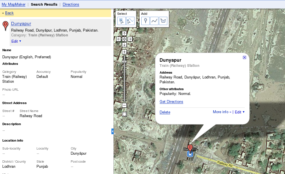
When these polygons are marked correctly, any feature marked on Map Maker automatically gets populated with these address attributes. For example, consider the example shown in the screen shot attached.
This is a railway station marked in Pakistan. The polygon(s) under which this feature was marked populated automatically in their respective fields i.e. under the 'Location Info' the 'State', 'District/County', 'City' fields were populated with the names of the polygons as the feature was marked in a location which was encompassed by them.
The mapping, State -> Governorate seems to be fine. Going down to Districts, Cities, Locality and Sub Locality mapping is where i see that we might have an issue.
So, it'd be great if you could propose a model for mapping Kuwait address hierarchy with respect to Map Maker administrative features. You may also want to visit a thread where we had a similar conversation with mappers from Costa Rica:
Regards,
Map Maker Guide.

Jabran
Jun 16, 2010, 6:49:23 AM6/16/10
to map-countr...@googlegroups.com
MMG, by the way, why don't we make postal code search available as
well? So far it doesn't result anything.. At least for Pakistan.
well? So far it doesn't result anything.. At least for Pakistan.
Regards,
Jabran
Hunza Landside Relief Support
www.local.com.pk/hunza
-----------------------
Sent from iPhone
> --
> You received this message because you are subscribed to the Google
> Groups "Country-specific topics" group.
> To post to this group, send email to map-countr...@googlegroups.com
> .
> To unsubscribe from this group, send email to map-country-spec...@googlegroups.com
> .
> For more options, visit this group at http://groups.google.com/group/map-country-specific?hl=en
> .
> <Image.png>

dushya...@google.com
Jul 5, 2010, 6:40:02 AM7/5/10
to map-countr...@googlegroups.com
Nice Idea, Jabran :-) Searching by postal/zip code would indeed be helpful. I'd request you to post this on Issue Tracker so that others may vote for this and raise the priority of this issue.
Regards,
Dushyant
Regards,
Dushyant
Jabran
Jul 5, 2010, 6:51:31 PM7/5/10
to map-countr...@googlegroups.com
OK. Its added and interested people can vote here. http://code.google.com/p/google-mapmaker/issues/detail?id=882
Cheers
Regards,
Jabran
——————————————————————————————————————————————
New feedback form to send us suggestions/corrections regarding Hunza landslide relief support
www.local.com.pk/hunza
Regards,
Jabran
——————————————————————————————————————————————
New feedback form to send us suggestions/corrections regarding Hunza landslide relief support
www.local.com.pk/hunza
--
Reply all
Reply to author
Forward
0 new messages