lascopy strange artifact output on classifiation
112 views
Skip to first unread message

Support at rapidlasso
Dec 10, 2021, 3:01:18 PM12/10/21
to LAStools - efficient tools for LiDAR processing
There was a request to check for an error on lascopy.
Due this happen may to other users and to have it documented
here a small post about the issue.
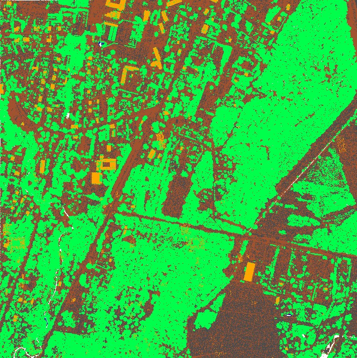
The challenge was to join 2 point clouds:
The first file got (almost) all.
The second file got the classification of some points to classify them as buildings.
The command was
lascopy.exe -i only_buildings.laz -i everything.laz -classification -o result.las
The result is like this:
.
Due this happen may to other users and to have it documented
here a small post about the issue.
The challenge was to join 2 point clouds:
The first file got (almost) all.
The second file got the classification of some points to classify them as buildings.
The command was
lascopy.exe -i only_buildings.laz -i everything.laz -classification -o result.las
The result is like this:
.
As you see there are some wrong classifications:
So the result was not as expected and had those "ghost" buildings within somewhere.
Analysis of the data show, that the source GPS timestamp in the source is not unique.
This is a problem - due lascopy use ONLY the timestamp to match the second input
with the first input points.
Suggestion of the user was to extend the match function to give more match options.
E.g. match only if also [ XYZ | scanner_channel | number_of_return ] match.
This would be possible, but it will
- slow down the show.
- consume a lot of memory.
- take quite a bit of my time.
Therefore I was looking for another solution.
My first suggestion would have been:
Try to keep the data clean.
If you think you need to have multiple identical timestamps in your data
try to keep them identifiable.
Then you have the option to LASsplit them.
Do the classification only on the suitable set of data.
Merge the data again.
In our case the data are mixed up somehow and I did not see a point to separate them.
Anyway, the LAStools are hopefully powerful enough to solve the problem.
This is what I did:
a) Merge the data, put the most wanted data in front:
lasmerge64.exe -i only_buildings.laz -i everything.laz -o work.laz
b) Remove the duplicates:
lasduplicate64.exe -i work.laz -o result.laz
The results seem reasonable to me.
Please let me know if there is something wrong in my thinking.
If there is a huge demand of extend lascopy just let me know.
~Jochen

Jorge Delgado García
Dec 11, 2021, 6:30:21 PM12/11/21
to last...@googlegroups.com
Obviously, if lascopy only considers the GPStime it will have problems badly if you need to work with multi-sensor (or multi-channel) systems since for the same time we will have several records (3Dpoints). The solution you propose to split each of the data sets seems to be adequate, and then perform the merge. The improvement (which I do not consider to be a priority since the process can be done without major problem) should take into account the GPStime and the SensorID (or SensorChannel), this could be more or less fast if you have data sorted by GPStime, selecting the corresponding sensor or channel.
The truth is that it is going to be more and more common to find multi-sensor/multi-channel data.
Jorge Delgado
--
Download LAStools at
https://rapidlasso.de
Manage your settings at
https://groups.google.com/g/lastools/membership
---
You received this message because you are subscribed to the Google Groups "LAStools - efficient tools for LiDAR processing" group.
To unsubscribe from this group and stop receiving emails from it, send an email to lastools+u...@googlegroups.com.
To view this discussion on the web visit https://groups.google.com/d/msgid/lastools/9f82a45b-079b-48d5-9ff0-d114edcad58en%40googlegroups.com.
--


Aneta Szostak
Nov 15, 2022, 7:31:33 AM11/15/22
to LAStools - efficient tools for LiDAR processing
Dear Jochen and Jorge,
I'm excited exploring again all wonders of LASTools! I found this thread while searching for funcionality of copy classification from archive to newly acquired data. I would imagine to have it solved by XYZ proximity of points within predefined precision.
From documentation I see, that copy can be done based on GPS time or points order.
Would it be possible to extend tool functionality?
Thanks and regards,
Aneta
From documentation I see, that copy can be done based on GPS time or points order.
Would it be possible to extend tool functionality?
Thanks and regards,
Aneta

Jochen Rapidlasso
Nov 15, 2022, 7:36:23 AM11/15/22
to LAStools - efficient tools for LiDAR processing
Hi Aneta,
yes, we could implement this. But: Can't you do this using lasduplicate? You have a "-nearby" attribute there, which just should do the job. Just merge in right order and then remove the duplicates nearby. If this does not work: Please provide a small example and I will have a closer look,
Thanks,
Jochen @rapidlasso
Reply all
Reply to author
Forward
0 new messages