Problem with Version 1.4 lidar in zlas format
127 views
Skip to first unread message

Matthew Robbins
Nov 22, 2017, 11:01:40 PM11/22/17
to last...@googlegroups.com
I downloaded some Virginia (USA) lidar from this website:
It was in .zlas format. I use lasliberator to save it as .las. It wouldn't save in laz format even after I upgraded to the latest version of lastools.
It's really dense with points, so the files are big.
Here is a report from lasinfo:
The report says it's in a Virginia state plane, but I've already liberated, reprojected into UTM 17, and merged the files. The UTM eastings and northings look good.
Here's the smallest tile (las, 13MB):
I'm hoping to do two things:
1. Save it in laz format, and
2. Save it in version 1.2, if that's possible
Thanks!
Matthew
Cincinnati

Martin Isenburg
Nov 23, 2017, 1:09:21 AM11/23/17
to LAStools - efficient command line tools for LIDAR processing
Hello,
it seems that Virginia is not for LiDAR lovers. Apparently they chose store open and tax-payer funded data in a closed and proprietary format. It seems the joke is no longer on West Virginia ... (-;
Can you live with LASliberating your LiDAR to uncompressed LAS 1.4 and then use las2las to downgrade to compressed LAS 1.2?
Regards,
Martin
--
Download LAStools at
http://lastools.org
http://rapidlasso.com
Be social with LAStools at
http://facebook.com/LAStools
http://twitter.com/LAStools
http://linkedin.com/groups/LAStools-4408378
Manage your settings at
http://groups.google.com/group/lastools/subscribe
Matthew Robbins
Nov 23, 2017, 5:59:04 PM11/23/17
to LAStools - efficient tools for LiDAR processing
Martin,
I was able to lasliberate it, reproject into UTM with las2las, and then tile a portion using las2las with -keepxy (not -keepXY!).
I wasn't originally able to save it as laz or get it into version 1.2, but then downloaded all new lastools files, and repeated, except I merged and clipped the area of interest. The I tried this command:
las2las -i *.las -o PC_ver1pt2.laz -set_version 1.2
Which was still too big (300+ MB laz, 2+ GB las), so I tiled it to 500m, and... it worked in the software I use.
Matthew
Cincinnati
Martin Isenburg
Dec 11, 2017, 8:17:06 PM12/11/17
to LAStools - efficient command line tools for LIDAR processing
Hello Matthew,
have you contacted the folks running the LiDAR portal for Virginia to ask them why they distribute open data in a closed format? Most federal guidelines (such as the recently released tender guide for all future Canadian LiDAR acquisitions) explicitly state that closed and proprietary delivery formats are to be avoided.
The Virginia Geographic Information Network (VGIN) is now listed in our "HALL OF SHAME". The VGIN (whose purpose, powers and duties are to facilitate the cost-effective development and use of spatial data, GIS, and related technologies throughout the Virginia Commonwealth, to foster the creative utilization of geographic information and oversee the development of a catalog of GIS data available in the Commonwealth) was nominated to the "HALL OF SHAME" for providing state-wide LiDAR collected as part of 3DEP as "open data" but in a closed and proprietary vendor format with the file extension *.zlas ... (-;
Regards,
Martin
Matthew Robbins
Dec 11, 2017, 8:36:40 PM12/11/17
to last...@googlegroups.com
Martin,
No, I haven’t. Are you aware of a US federal guide that states that? I’m hoping to reference a US document when I write.
Matthew

Stoker, Jason
Dec 12, 2017, 3:52:47 PM12/12/17
to <lastools@googlegroups.com>
Hi Matthew, for the Federal government we have this Executive Order we follow: https://obamawhitehouse.archives.gov/the-press-office/2013/05/09/executive-order-making-open-and-machine-readable-new-default-government- Note this does not necessarily apply to states and counties, as they may have made their own independent decisions for how they can manage and provide data. Any data collected by/with the 3D Elevation Program should be provided in open formats though.
Right now LAS satisfies those requirements for our point cloud data, and OGC has made LAS 1.4 a community standard. We're hoping LAZ will someday satisfy completely as well.
I'm curious though- why not get these data from the National Map? They are already in LAS format. https://viewer.nationalmap.gov/basic/ We have around 35,000 LAS files from Virginia available for download for free (screenshot of extent below). If you were interested in 1 meter & seamless 10 meter DEMs, we provide those as well. If there is something wrong or unappealing with our services, definitely let me know so I can relay it to our production and delivery teams- we're always looking for feedback on how to improve, even under relatively static budget situations.
For those on this forum who may not be aware, as part of 3DEP we have 1.28+ MILLION LAS files available for download from around 1,095 projects via The National Map as of 12/12/17, with a total size of over 104.2 TB (zip compressed). We currently zip metadata in with the LAS files, so there is some additional info in the zip than just a LAS file.
We are also in the process of compressing all of our files to LAZ as a download option- as of today we have about 621,045 LAZ files available at a total size of 14.39 TB- but they have not made it to the VA data yet. Think they are processing in alphabetical order :-)

Jason M. Stoker, Ph.D
US Geological Survey
National Geospatial Program
Office: 970-226-9227
Cell: 605-496-3513
My USGS Profile
US Geological Survey
National Geospatial Program
Office: 970-226-9227
Cell: 605-496-3513
My USGS Profile
Matthew Robbins
Dec 12, 2017, 10:12:57 PM12/12/17
to last...@googlegroups.com
Jason,
Thanks for the quick reply. I'm assuming you saw the letter I sent this afternoon to the Virginia Base Mapping Project (VBMP), where I copied the USGS 3DEP website. I was mostly complaining to them about using zlas.
I haven't used The National Map (TNM) for two reasons.
First, I wasn't aware the Virginia lidar was there. I've been following Virginia lidar since about 2011, when I drove to the GIS office in Blacksburg to inquire about getting their entire dataset. I didn't walk out with it---they put it on their FTP site, and I downloaded it the next day.
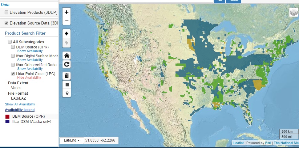
And second, I tend to use EarthExplorer (which seems related to TNM), and it seems to lag other sources significantly. Even now, it doesn't cover even half the country (presumably because 3DEP has a long way to go). See attached image, if it makes it through the reflector.
I will say this: I'm really glad you and USGS are doing this. It's awesome.
A few complaints. The Open Topography lidar download is *the best*. You draw a rectangle and download the data soon after. I'd love love love a shp file upload (or a simply polygon or line+buffer tool) capability so I can download just the data I need. (Also, a trick for the OpenTopography site: If you hover over "DATA", and then select "Lidar Point Cloud", it just gives a list of the datasets. The secret is: Click "DATA"!!! That goes straight to the coverage map and the download tool. OpenTopography---you should probably fix that.)
As it happens, I was trying to find some 3DEP data for Los Angeles that hasn't been published yet, and that was my first time using TNM's new (to me) webpage. I think I found an old DEM for a large part of LA, but it was a 2.6GB download. And I really want the lidar point cloud, not a DEM.
Is there anywhere to check when the Los Angeles 3DEP data will be available?
I see TNM doesn't have most of the Kentucky lidar (which might predate 3DEP, but I though FEMA had some money in that). That's been available at Kentucky's FTP site for some time.
I'm downloading 21 tiles from Virginia right now. There doesn't appear to be a "download all" button. I know on EarthExplorer, I haven't been able to do the bulk download in years. It's broken for me. I have to download each tile separately. The TNM download seems to have a longer list of "hits", which makes it easier. I typically go through and turn on each footprint. If I need it, I leave it on, if not, I turn it back off. Then I go through and download each separately. In EarthExplorer, once I'm done downloading a tile, I turn off the footprint. TNM has a nicer interface with everything in one list.
Again, Jason, thanks.
Matthew
Cincinnati

Kirk Waters - NOAA Federal
Dec 13, 2017, 7:50:37 AM12/13/17
to LAStools - efficient command line tools for LIDAR processing
Matthew,
You can also get most of the Virginia data on the NOAA Digital Coast (https://coast.noaa.gov/dataviewer). You'll see some similarities to functionality with OpenTopo, though not a shapefile upload. We focus primarily on the coast, so the more inland data isn't there. LAS and LAZ (preferred) are available, just make sure to pick the output type of points during checkout. I think we're primarily missing the 2015 data.
Kirk Waters, PhD | NOAA Office for Coastal Management
Applied Sciences Program | 2234 South Hobson Ave
843-740-1227 | Charleston, SC 29405
843-740-1227 | Charleston, SC 29405
Matthew Robbins
Dec 15, 2017, 5:13:07 PM12/15/17
to last...@googlegroups.com
Kirk,
Thanks! Also, to clarify, OpenTopo doesn't have a shapefile upload to the best of my knowledge. I wish it, and other lidar download websites, would have that capability, though.
I'm pretty sure I've used the NOAA site to download lidar for two areas near San Luis Obispo and another at Big Basin State Park, in California.
I took a screenshot of the NOAA lidar coverage (there's also some coverage in Alaska and maybe Hawaii). See attached.
Matthew
Cincinnati
Reply all
Reply to author
Forward
0 new messages