Import USGS quad KMZ
331 views
Skip to first unread message

Ben Burnett
Jun 11, 2017, 11:11:17 PM6/11/17
to GPS Essentials
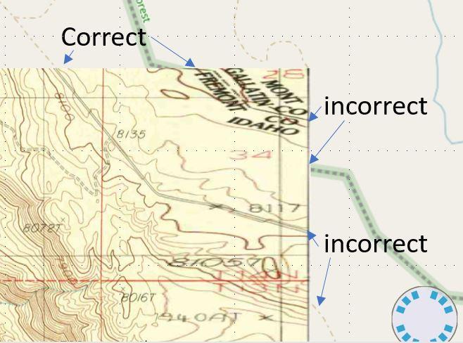
I am trying to import USGS 7.5 minute quads in .kmz format, but the files end up skewed. (in screenshot, features line up correctly along north edge, but not on east edge).
Features also seem to line up on west side but not south side.
The kmz files are from:
Specifically I'm using the Latham Spring Quad (and surround quads) in Idaho, near the ID/WY/MT boundary.
When multiple adjacent quads are displayed, they overlap (which they should not).
I know that this isn't a problem with the files because they project neatly in ArcGIS.
I have wondered if this is a problem with the datum I'm using, but I've tried changing that (NAD 27, NAD 83 CONUS, or WGS 84) and got the same result.
Any ideas?
Alternatively, does anyone have another way of getting many USGS quads imported efficiently?
--
GPS Essentials Version: 4.4.22
Android Version:7.1.1Device Model:Pixel XL
Device ID: (If you uploaded bug reports this helps to associate them with your question or report. If you have security concerns, send to sup...@mictale.com)

Michael Schollmeyer
Jun 14, 2017, 2:49:37 AM6/14/17
to gpsess...@googlegroups.com
It looks a little stretched, as if the northern coordinates are ok but the southern coordinates are shifted north. Did you try to open the file in Google Earth?
Regards, Michael
mictale.com/ms
--
> On Jun 11, 2017, at 8:21 PM, Ben Burnett <burne...@gmail.com> wrote:
>
> Here is the screenshot
>
> --
> You received this message because you are subscribed to the Google Groups "GPS Essentials" group.
> To unsubscribe from this group and stop receiving emails from it, send an email to gpsessential...@googlegroups.com.
> To post to this group, send email to gpsess...@googlegroups.com.
> Visit this group at https://groups.google.com/group/gpsessentials.
> For more options, visit https://groups.google.com/d/optout.
> <gpsEssentials.JPG>
Ben Burnett
Jun 15, 2017, 6:16:10 PM6/15/17
to GPS Essentials
Yep, looks fine in G Earth. The distortion isn't distributed equally throughout the image, so in retrospect, it doesn't look like a projection issue.
Michael Schollmeyer
Jun 17, 2017, 1:31:54 PM6/17/17
to gpsess...@googlegroups.com
Can you share the file? You can either post it here or send me an email.
Regards, Michael
mictale.com/ms
--
Regards, Michael
mictale.com/ms
--

mike slev
Apr 11, 2022, 4:03:19 PM4/11/22
to GPS Essentials
Hello,

Thanks!
Michael
mike slev
May 6, 2022, 7:46:02 PM5/6/22
to gpsess...@googlegroups.com, Michael Schollmeyer
Is this app still supported? I really like using it, but I haven't had luck resolving this distortion issue.
Thank you,
Michael
On Wed, Apr 20, 2022 at 8:39 AM mike slev <mike...@gmail.com> wrote:
I'm following up on this question. This continues to be an issue for me. I used GPS essentials for many years without encountering this problem. Now I have a new phone and I'm seeing this type of distortion on most of my custom maps. I haven't been able to figure out why.Thanks for your help,Michael
To view this discussion on the web visit https://groups.google.com/d/msgid/gpsessentials/a890df27-3895-482c-baa8-8482983e0aedn%40googlegroups.com.
Reply all
Reply to author
Forward
0 new messages