Drawing Roundabouts - Google instructions are incorrect.

vandelay
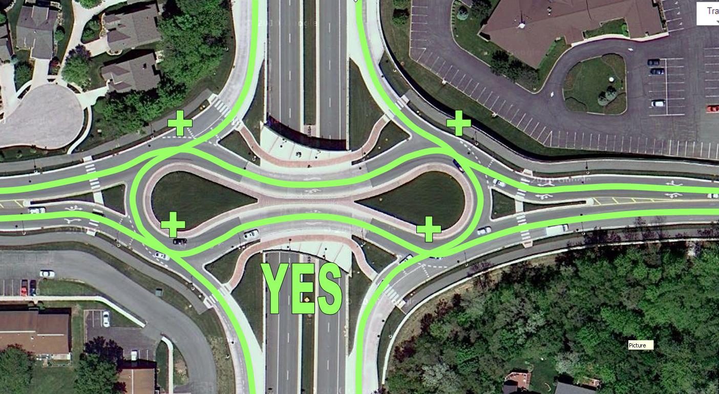
Correct drawing:


delta fox
djboge
delta fox
vandelay
vandelay
djboge
vandelay
vandelay
djboge

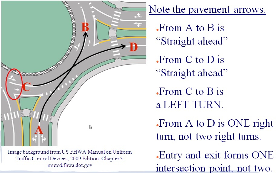
In this example, if you were traveling north (northeast) on Main, and wanted to go west (northwest) on Smith, I'm not sure which of these directions would be generated:
a. Head northeast on Main St. At the traffic circle, take the second (or would it say third?) exit onto Smith Ave.
b. Head northeast on Main St. Turn left on Smith Ave.
At any rate, I think we're really splitting terminology hairs here. In general, people know how to navigate roundabouts and pay attention to the signs in the area. It's not as if we're trying to program a robot to drive correctly based on Maps directions.
I'm still not sure what the SPECIFIC problem with drawing roundabouts in the "incorrect" way is, other than the fact that its incorrect IN THEORY.
vandelay
vandelay
vandelay
djboge
Geoffrey Perez
--
You received this message because you are subscribed to the "General Map Maker" Google group.
- To post a public reply in this same thread:
Reply to this e-mail and your note will soon be posted.
- To post a note to the group on a *different* General Map Maker topic:
Visit http://goo.gl/DeX9Z and click on "New topic"
or
E-mail google-...@googlegroups.com
- To unsubscribe from this list:
Send email to
google-mapmak...@googlegroups.com
- To see additional useful options:
Visit http://goo.gl/GDnr and click on "Membership."
Thanks for using Google Map Maker! :-)
Geoffrey Perez
--
Geoffrey Perez
djboge
Flash
vandelay
vandelay
Geoffrey Perez
--
vandelay

Geoffrey Perez
--
vandelay
vandelay
vandelay

vandelay


delta fox
djboge
vandelay
vandelay
vandelay
vandelay
djboge
delta fox
Geoffrey Perez
At least you now admit that Google instructions are valid in some cases ;-)The main difference between roundabouts in Germany and New Zealand is that one is clockwise, the other counterclockwise. I hope this is marked correctly on Google Maps...
--
vandelay
vandelay
delta fox
vandelay
vandelay
delta fox
vandelay
djboge
delta fox
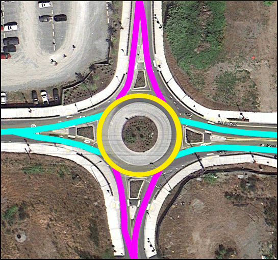
You must have higher editing priveleges than I do. Any time that I have tried to draw a new segment to correct a drawing (as you have done here), it triggers a review process and it never gets approved. It sits there, untouched and unapproved for weeks, and then someone from Google redraws the whole thing anyway.
vandelay
They draw nice circles, I'll give them that. They can draw a much more perfect circular shape than I can. But they get the intersections all wrong, create misleading information, and it fails to line up with the satellite image.
vandelay
vandelay
Willy Hrachovina
KaliJay
delta fox
vandelay
vandelay
vandelay
Nels
Flash
vandelay
Nels
KaliJay
Flash
The problem is they are different from intersections in that they don't have lights or stop signs; instead you must yeild to the people already in the circle. You can get in the circle and turn continuous circles and everyone entering must yield to you; I've done this to get a GPS trace :) And they are, at least in my area, marked as roundabouts. You need the roundabout marking so that someone isn't confused by directions; they see the roundabout signs, they see they roundabout, thus Directions should say "At the roundabout...". The really big difference between them and European traffic circles is that they generally have approaches that make a sharp turn to slow you down as you enter, they usually are not perfect circles, and that if you take the first right then you barely brush the edge of the circle.
I'm wondering if perhaps we do want to have eight intersections, and then place two of them extremely close together. It would be up to Google, but here's my thoughts:
If we just do four and you are taking the first right, you might get confused by "Turn right at the intersection". It might be technically right, but you can see a traffic circle and it is not mentioned.
If there are eight, with every two really close together (almost touching), then it would look like it is designed in Maps, but Directions could then say "At the roundabout, take an immediate right". That little section of roundabout between the two intersections would be there to trigger the directions to say it so it makes sense to drivers.
As Nels asked, I'm writing this up for my RER Guide to be passed on further; what are the expert opinions on what I'm proposing?
vandelay
vandelay
Thanks for the redo on that. I can use my overlay to adjust the alignment to a more precise leve. But unless there's a shift in GMM policy, it'll probably be redrawn as a traffic circle again by someone else.
KaliJay
KaliJay
Flash
vandelay
vandelay
delta fox
in directions updating)
| 1. Head southeast on Rue Paul Bellamy | ||
52 m | ||
| 2. At the roundabout, take the 1st exit | ||
10 m | ||
| 3. At the roundabout, take the 2nd exit onto Rue Paul Bellamy | ||
51 m |
Rue Paul Bellamy |
Nels
vandelay
Saikrishna Arcot
Flash
vandelay
vandelay
Flash
vandelay
vandelay
vandelay
It was good while it lasted - The Bailey/Radio roundabout has now been redrawn as an incorrect eight-pointer by shruthi.
vandelay

Flash
vandelay
Thanks for the clarification, but I'm still not sure that D-Map's position makes sense. "Roundabout/Traffic Circle" is a segment attribute but it does not pertain to entry yield control. There are roundabouts that are signalized (mostly in the UK, Ireland, and Australia) where entering traffic has the right of way when the light's green, and there are traffic circles in New Jersey where the entering traffic sometimes has the right-of-way (http://g.co/maps/egx5c), and there are rotaries where entering traffic can "merge" side-by-side with circulating traffic where neither one really yields. All of these use the same "Roundabout/Traffic Circle" segment attribute and they are all mapped the same in Google Maps, despite the fact that they are all structured (and operate) completely differently. So I don't see why using the Roundabout/Traffic Circle segment attribute would instruct a driver to yield. If it does, then it's wrong in many of these other applications.
assa...@gmail.com
You received this message because you are subscribed to the “General Map Maker” Google Group.
- To post a public response in this same thread, please reply to this e-mail.
- To find a list of Frequently Asked Questions, visit- http://goo.gl/yuVdY
- To post a new topic, visit- http://goo.gl/DeX9Z & select 'Post a question'
- To unsubscribe from this list, manage your subscriptions here: http://goo.gl/oGfnJ
Thanks for using Google Map Maker! =)
vandelay
assa...@gmail.com
vandelay
