Parking Lot Road Policy

sewell...@gmail.com
For example, here is a shopping center near where I live, where new roads were recently added:
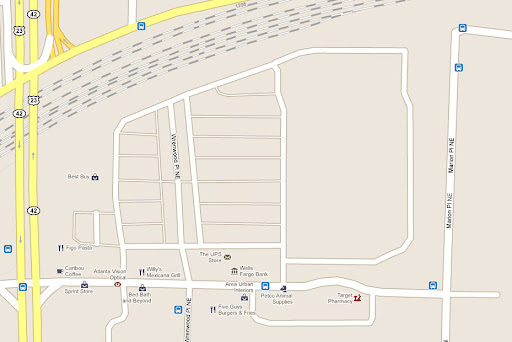

Woodbine, the north/south street, should be a terminal road. It starts at an actual street and terminates at a parking lot, so it is terminal. But all of the parking bays are not roads. They will not help anyone find their way anywhere, because they don't go anywhere. They are actually the content of an urban block, not the connection between blocks. And, as I said before, they unnecessarily clutter the map. Parking would be better represented by a boundary.
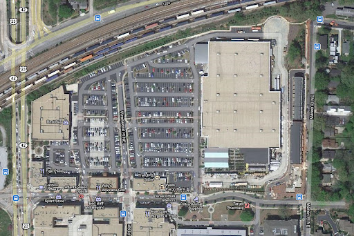
Example #2 is an area I am working on. Recently a convention center near me built a new parking lot, replacing the blocks and streets that were there before.

I have been trying to remove Western Ave, Davis St, and Jones Ave, because these roads are gone. They no longer have a name, and they no longer serve as roads. The previous roadbed has been removed, and it has been replaced by a parking lot. It is merely happenstance that parking aisles are located in the same location, because they are not the same, and they do not even connect in the same way - Jones is now divided by a sidewalk. But Google moderators prefer to smugly deny my edits without referring to any specific rules on how things should be done.
So, I propose that parking lots should be represented by polygons, except for terminal roads that lead from an actual street into the parking lot without giving direct access to spaces. If there is contradictory policy somewhere, please let me know. Let us not forget that any user can see the world in full detail by merely clicking on the satellite button. Our map is a simplification and should not be cluttered with insignificant roads.
Patrick S

It doesn't make sense to show these aisles as roads, and it only clutters the map. Wrenwood, which runs from an actual city street and terminates in a parking lot should be a terminal road, but the remainder of the parking lot aisles should be shown as a polygon.
Here's an example I've been working on:
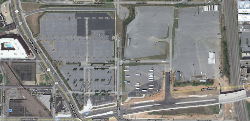
I've been trying to remove Western, Davis, and Jones, because these city streets have been replaced by a parking lot. They were formerly urban blocks, but they have been removed and they no longer have names. It is merely coincidental that aisles run in the same location (although Jones is now split by a sidewalk). But moderators ask me not to remove these streets.
Is there a policy? I propose that streets leading into a parking lot without any actual parking access should be terminal streets, but all other parking lot streets should be removed and shown as boundaries.
zxrayz

rjhintz
deltafox
In the absence of any general policy, some mappers seem to enjoy adding as much details as they can, internal parkings aisles (why not every individual car place ?) or even lanes in toll booth areas - I think there is better to do if they really want to spend their time... More serious, it will make other mappers spend even more time to clean the area when the parking is deleted, or each time there is a new imagery in the area, since there is no quicker way than selecting and moving each intersection one by one ! At least as long as GMM do not provide any way of moving/deleting a whole area
Best is the enemy of Good ;-)
rjhintz
Rich
leromag
deltafox a écrit :
> deleted since they no longer exist as city streets, and every reviewer
> should understand it once you explain it to him - even Google reviewers ;-)
>
> In the absence of any general policy, some mappers seem to enjoy adding as
Brian N
It would be really pointless to have a cycle of:
- Person A thinks the details are important and adds them
- Person B thinks the details are unnecessary and removes them to clean up the map
- Person A gets annoyed that Person B removed them, and adds them again...
and so on...
Basically I am ALL FOR standards as long as they are searchable and easy to find the info you are looking for. i.e I should be able to search "Parking Lot' and see an example of how to do it and how not to do.
Aaron Private Email
under roads you find segments. In segments has enclosed traffic /
parking lot. These roads are made specifically for those said roads in
between parking spots. Take a look at the help page.
http://www.google.com/support/mapmaker/bin/static.py?page=guide.cs&guide=1094314&topic=1094373&answer=1098048