National Forest creates a sea of green
122 views
Skip to first unread message

fhdogs
Apr 17, 2012, 5:46:17 PM4/17/12
to google-...@googlegroups.com
I'm looking for some assistance on how to deal with the Green Mountain National Forest (http://goo.gl/AGstT) in my soon to be town.
I never noticed this before, but the southern half of the forests boundary is way off. If you look at any map of the national forest (even on other maps sites) the Google Maps western boundary is a few miles further west than it should be. The actual border is close to RT-7 which runs through the middle of the current area.
The reason I've actually noticed this is because I just started editing in the Town of Manchester (http://goo.gl/TYy05) and couldn't figure out why none of the boundaries for shopping centers and schools were visible. Apparently a forest layer has a higher hierarchy than normal vegetation (which I thought was rendering the green).
So here's my problem... If I try to edit the forest shape only the northern section becomes editable. I was able at one point to select the southern section, but I received a pop-up telling me the 500 point limit was reached. How can I correct this boundary so that the town is not a sea of green? My only guess is to report this, but in my experience, that is not the fastest option, especially because this change is going to require quite a bit of time to accurately adjust.
I'd really like the area to have a green base color, but since Manchester is a heavily traveled tourist destination with many outlet stores and hotels. I'd rather have a visually understandable map, that correctly shows buildings, and boundaries since the shopping area is mostly a cluster of small oddly shaped properties.
Thanks
-Mike
Rahim
Apr 26, 2012, 6:39:08 AM4/26/12
to google-...@googlegroups.com
Hello Mike,
Ah, the canopy of green over Manchester! Thanks for catching.
Yes, you guessed it right. Since, it’s a huge polygon at stake and editing it may not feasible from your end. Therefore, the best way to get this fixed is use Report a problem option on Google maps
~Rahim
Ah, the canopy of green over Manchester! Thanks for catching.
Yes, you guessed it right. Since, it’s a huge polygon at stake and editing it may not feasible from your end. Therefore, the best way to get this fixed is use Report a problem option on Google maps
~Rahim
fhdogs
Apr 26, 2012, 9:00:39 AM4/26/12
to google-...@googlegroups.com
Thanks Rahim, I've already reported it, Since I've been mapping the entire "downtown" area I'm looking forward to being able to see the boundaries that I've mapped, and adding new ones that I'm holding off on until they are visible.
fhdogs
May 11, 2012, 12:41:48 PM5/11/12
to google-...@googlegroups.com
Just an update on this... I just noticed that the USDA KML files have this same error so maps must've imported this bad data from them.
Wish me luck on getting this fixed from the government end.
-Mike
assa...@gmail.com
May 11, 2012, 12:56:25 PM5/11/12
to General Map Maker on behalf of fhdogs
Mike, I'm not sure if the error you're facing is that there are multiple boundaries for National Forests. From memory there are the property boundaries, the administrative boundaries and I think one or two others. Is the actual boundary wrong or is it a "service area" boundary? I remember looking these boundaries for the White Mountains when I placed them in OSM.
Sent via BlackBerry from T-Mobile
From: General Map Maker on behalf of fhdogs <google-...@googlegroups.com>
Sender: General Map Maker on behalf of fhdogs <google-...@googlegroups.com>
Date: Fri, 11 May 2012 09:41:48 -0700 (PDT)
ReplyTo: General Map Maker on behalf of fhdogs <google-...@googlegroups.com>
Subject: Re: National Forest creates a sea of green
--
You received this message because you are subscribed to the “General Map Maker” Google Group.
- To post a public response in this same thread, please reply to this e-mail.
- To find a list of Frequently Asked Questions, visit- http://goo.gl/yuVdY
- To post a new topic, visit- http://goo.gl/DeX9Z & select 'Post a question'
- To unsubscribe from this list, manage your subscriptions here: http://goo.gl/oGfnJ
Thanks for using Google Map Maker! =)
fhdogs
May 11, 2012, 1:06:07 PM5/11/12
to google-...@googlegroups.com
This is the actual boundary of the GMNF. I have several maps of all the smaller areas within the forest, but the overall boundary is way off. I've got some calls into Utah to work on this, and I should be headed over near the ranger station today.
On Friday, May 11, 2012 12:56:25 PM UTC-4, Andrew Sawyer wrote:

For rough understanding.... the entire red area is currently labeled as GMNF when it is not part of it.
On Friday, May 11, 2012 12:56:25 PM UTC-4, Andrew Sawyer wrote:
Mike, I'm not sure if the error you're facing is that there are multiple boundaries for National Forests. From memory there are the property boundaries, the administrative boundaries and I think one or two others. Is the actual boundary wrong or is it a "service area" boundary? I remember looking these boundaries for the White Mountains when I placed them in OSM.Sent via BlackBerry from T-Mobile
From: General Map Maker on behalf of fhdogs <google-mapmaker@googlegroups.com>Sender: General Map Maker on behalf of fhdogs <google-mapmaker@googlegroups.com>
Date: Fri, 11 May 2012 09:41:48 -0700 (PDT)
ReplyTo: General Map Maker on behalf of fhdogs <google-mapmaker@googlegroups.com>
fhdogs
May 11, 2012, 1:19:10 PM5/11/12
to google-...@googlegroups.com
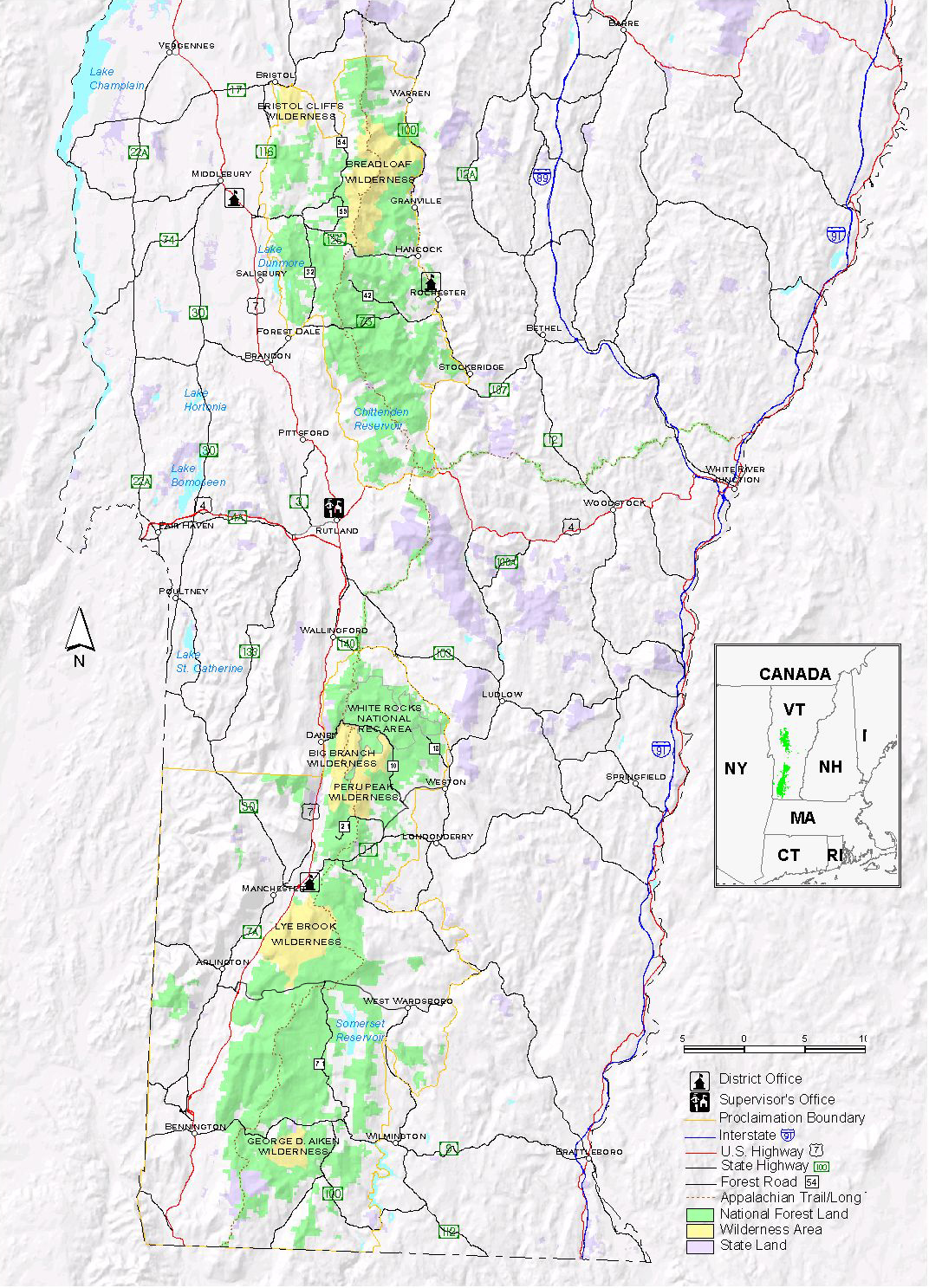
Forgot this one... Here is an actual USDA map that is correct.
Dendros
May 11, 2012, 3:01:44 PM5/11/12
to google-...@googlegroups.com
When importing maps an important thing to know (and it would help TREMNDOUSLY if Google made it clear - because I haven't found it yet) Is that datum is being used. What is the starting point for zero for them? What standard is being used? NAD27, NAD83, WGS84? Something else? This can make a huge difference when getting information from places like USDA, BLM and the like, because the point where everything was measured from has changed many times, and is not even the same in other countries. If the standards do not match the data will all be different.
fhdogs
Jun 7, 2012, 11:38:49 PM6/7/12
to google-...@googlegroups.com
@Rahim Is there any way to get this looked into? I've reported it as many ways as possible. It would also be very helpful to get this area re-rendered so my edits show properly.
On Thursday, April 26, 2012 6:39:08 AM UTC-4, Rahim wrote:
Thanks
On Thursday, April 26, 2012 6:39:08 AM UTC-4, Rahim wrote:
Rahim
Jun 15, 2012, 6:49:37 AM6/15/12
to google-...@googlegroups.com
@Mike - Apologies if this is causing inconvenience to you and holding you back from fixing things. I think you should try posting this on Maps help forum to get a more appropriate reply on this.
~Rahim
Reply all
Reply to author
Forward
0 new messages